Algar elevation
Algar (Andalusia, Provincia de Cádiz), Spain elevation is 208 meters and Algar elevation in feet is 682 ft above sea level [src 1]. Algar is a seat of a third-order administrative division (feature code) with elevation that is 395 meters (1296 ft) smaller than average city elevation in Spain.
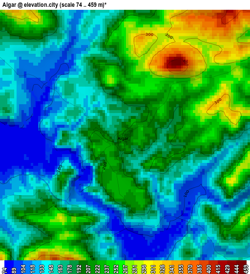
Below is the Elevation map of Algar, which displays elevation range with different colors. Scale of the first map is from 74 to 459 m (243 to 1506 ft) with average elevation of 188.6 meters (=619 ft) [note 1]
These maps also provides idea of topography and contour of this city, they are displayed at different zoom levels. More info about maps, scale and edge coordinates you can find below images.
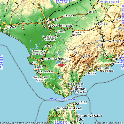
| \ | Map #1 | Topo.Map |
| Scale [m] | 74..459 m | × |
| Scale [ft] | 243..1506 ft | × |
| Average | 188.6 m = 619 ft | × |
| Width | 7.84 km = 4.9 mi | 250.9 km = 155.9 mi |
| Height | 7.84 km = 4.9 mi | 250.9 km = 155.9 mi |
| ↑Max Latitude | 36.692726° | 37.7773° |
| Latitude at center | 36.65748° | 36.65748° |
| ↓Min Latitude | 36.622218° | 35.52113° |
| ← Min Longitude | -5.699525° | -7.06183° |
| Longitude center | -5.65558° | -5.65558° |
| →Max Longitude | -5.611635° | -4.24933° |
Nearby cities:
Cities around Algar sort by population:
• Arcos de la Frontera elevation 144 m
17.3 km,  306°
306°
• Ubrique 325 m
18.8 km,  83°
83°
• Villamartín 149 m
22.5 km,  2°
2°
• Bornos 154 m
19.4 km,  335°
335°
• Prado del Rey 441 m
17 km,  31°
31°
• Alcalá de los Gazules 209 m
22.6 km,  195°
195°
• Paterna de Rivera 129 m
24 km,  231°
231°
• Espera 155 m
27.6 km,  330°
330°
• El Bosque 289 m
17.5 km,  50°
50°
• Benaocaz 780 m
21.4 km, 76°
• Villaluenga del Rosario 870 m
24.4 km, 79°
• San José del Valle 141 m
14 km,  245°
245°
Multilingual:
 En español:
Algar elevación 208 m.
 En France:
Algar élévation 208 m.


Sources and notes:
- [note 1] Map square and city borders are not equal. Map elevation data is calculated only from area inside that square.
- [src 1] Elevation data from geonames database provided with same terms of usage.
- [src 2] The elevation map of Algar is generated using elevation data from NASA's 3 arcsec (90m) resolution SRTM data.
- [src 3] Base (background) map © OpenStreetMap contributors tiles are generated by Geofabrik and OpenTopoMap.
Copyright & License:
This Algar Elevation Map is licensed under CC BY-SA. You may reuse any part from this page, if you give a proper credit by linking to this URL:
 More info on terms of use page.