Villamartín elevation
Villamartín (Andalusia, Provincia de Cádiz), Spain elevation is 149 meters and Villamartín elevation in feet is 489 ft above sea level [src 1]. Villamartín is a seat of a third-order administrative division (feature code) with elevation that is 454 meters (1490 ft) smaller than average city elevation in Spain.
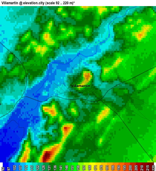
Below is the Elevation map of Villamartín, which displays elevation range with different colors. Scale of the first map is from 92 to 220 m (302 to 722 ft) with average elevation of 133.7 meters (=439 ft) [note 1]
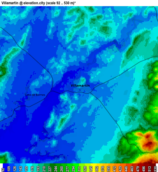
These maps also provides idea of topography and contour of this city, they are displayed at different zoom levels. More info about maps, scale and edge coordinates you can find below images.
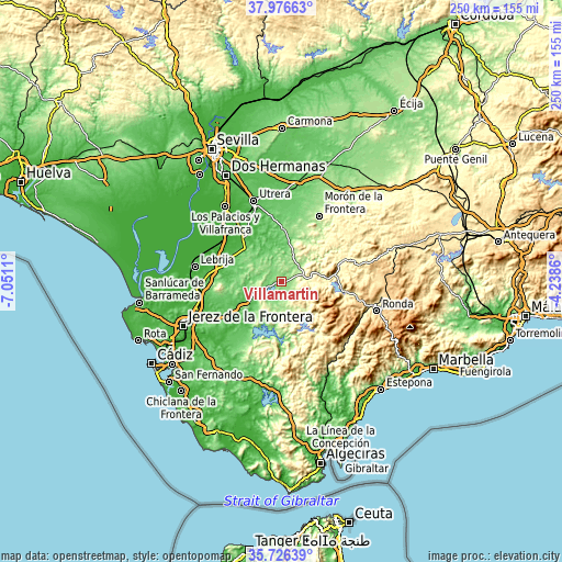
| \ | Map #1 | Map #2 | Topo.Map |
| Scale [m] | 92..220 m | 92..530 m | × |
| Scale [ft] | 302..722 ft | 302..1739 ft | × |
| Average | 133.7 m = 439 ft | 155 m = 509 ft | × |
| Width | 7.82 km = 4.9 mi | 15.64 km = 9.7 mi | 250.2 km = 155.5 mi |
| Height | 7.82 km = 4.9 mi | 15.64 km = 9.7 mi | 250.2 km = 155.5 mi |
| ↑Max Latitude | 36.894943° | 36.930079° | 37.97663° |
| Latitude at center | 36.85979° | 36.85979° | 36.85979° |
| ↓Min Latitude | 36.824621° | 36.789436° | 35.72639° |
| ← Min Longitude | -5.688795° | -5.732741° | -7.0511° |
| Longitude center | -5.64485° | -5.64485° | -5.64485° |
| →Max Longitude | -5.600905° | -5.556959° | -4.2386° |
Nearby cities:
Cities around Villamartín sort by population:
• Arcos de la Frontera elevation 144 m
19.1 km,  230°
230°
• Bornos 154 m
10.1 km,  241°
241°
• Montellano 262 m
16.4 km,  23°
23°
• Puerto Serrano 166 m
11.4 km,  52°
52°
• Prado del Rey 441 m
11.3 km,  135°
135°
• Algodonales 369 m
21.4 km,  83°
83°
• El Coronil 134 m
24.5 km,  2°
2°
• Espera 155 m
14.4 km,  276°
276°
• El Bosque 289 m
16.8 km,  132°
132°
• Algar 208 m
22.5 km,  182°
182°
• Zahara 491 m
22.7 km,  95°
95°
• Coripe 328 m
22.1 km,  55°
55°
Multilingual:
 En español:
Villamartín elevación 149 m.
 En France:
Villamartín élévation 149 m.
 Auf Deutsch:
Villamartín höhe über dem Meeresspiegel ist 149 m.

Sources and notes:
- [note 1] Map square and city borders are not equal. Map elevation data is calculated only from area inside that square.
- [src 1] Elevation data from geonames database provided with same terms of usage.
- [src 2] The elevation map of Villamartín is generated using elevation data from NASA's 3 arcsec (90m) resolution SRTM data.
- [src 3] Base (background) map © OpenStreetMap contributors tiles are generated by Geofabrik and OpenTopoMap.
Copyright & License:
This Villamartín Elevation Map is licensed under CC BY-SA. You may reuse any part from this page, if you give a proper credit by linking to this URL:
 More info on terms of use page.