Algarinejo elevation
Algarinejo (Andalusia, Provincia de Granada), Spain elevation is 606 meters and Algarinejo elevation in feet is 1988 ft above sea level [src 1]. Algarinejo is a seat of a third-order administrative division (feature code) with elevation that is 3 meters (10 ft) bigger than average city elevation in Spain.
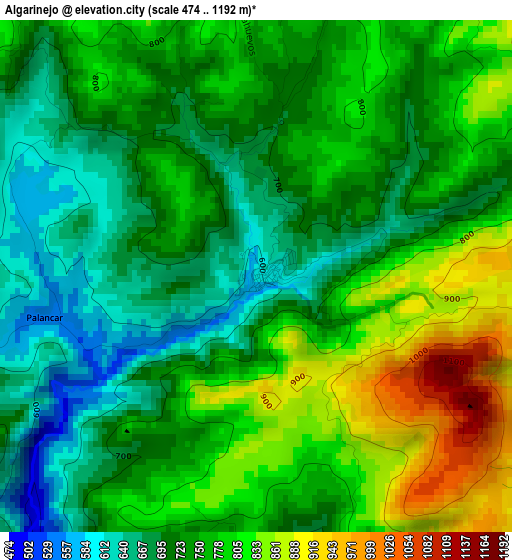
Below is the Elevation map of Algarinejo, which displays elevation range with different colors. Scale of the first map is from 474 to 1192 m (1555 to 3911 ft) with average elevation of 749.9 meters (=2460 ft) [note 1]
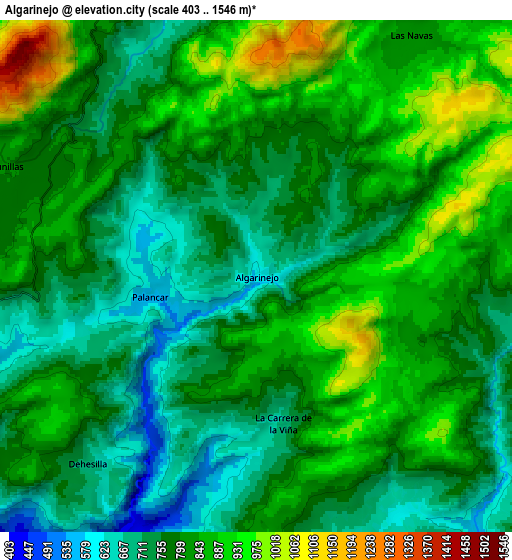
These maps also provides idea of topography and contour of this city, they are displayed at different zoom levels. More info about maps, scale and edge coordinates you can find below images.
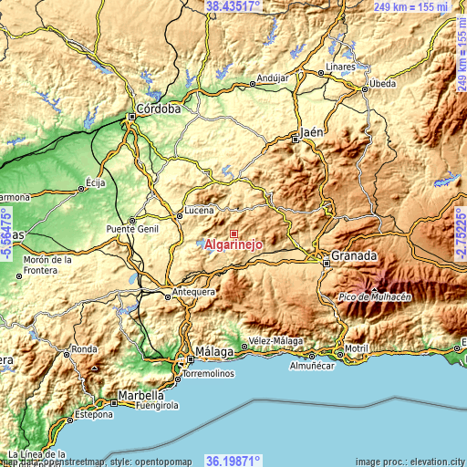
| \ | Map #1 | Map #2 | Topo.Map |
| Scale [m] | 474..1192 m | 403..1546 m | × |
| Scale [ft] | 1555..3911 ft | 1322..5072 ft | × |
| Average | 749.9 m = 2460 ft | 798.1 m = 2618 ft | × |
| Width | 7.77 km = 4.8 mi | 15.54 km = 9.7 mi | 248.7 km = 154.5 mi |
| Height | 7.77 km = 4.8 mi | 15.54 km = 9.7 mi | 248.7 km = 154.5 mi |
| ↑Max Latitude | 37.360197° | 37.395119° | 38.43517° |
| Latitude at center | 37.32526° | 37.32526° | 37.32526° |
| ↓Min Latitude | 37.290306° | 37.255336° | 36.19871° |
| ← Min Longitude | -4.202445° | -4.246391° | -5.56475° |
| Longitude center | -4.1585° | -4.1585° | -4.1585° |
| →Max Longitude | -4.114555° | -4.070609° | -2.75225° |
Nearby cities:
Cities around Algarinejo sort by population:
• Priego de Córdoba elevation 661 m
13 km,  345°
345°
• Loja 453 m
17.4 km,  177°
177°
• Rute 658 m
18.5 km,  270°
270°
• Huétor-Tájar 488 m
17.2 km,  145°
145°
• Montefrío 796 m
13.2 km,  91°
91°
• Iznájar 525 m
15.2 km,  240°
240°
• Carcabuey 617 m
16.7 km,  322°
322°
• Salar 557 m
21.1 km,  157°
157°
• Almedinilla 638 m
14 km,  25°
25°
• Zagra 677 m
7.8 km,  186°
186°
• Fuente-Tójar 587 m
20.7 km,  2°
2°
• Villanueva de Mesía 498 m
17.7 km,  133°
133°
Multilingual:
 En español:
Algarinejo elevación 606 m.
 En France:
Algarinejo élévation 606 m.
 Auf Deutsch:
Algarinejo höhe über dem Meeresspiegel ist 606 m.

Sources and notes:
- [note 1] Map square and city borders are not equal. Map elevation data is calculated only from area inside that square.
- [src 1] Elevation data from geonames database provided with same terms of usage.
- [src 2] The elevation map of Algarinejo is generated using elevation data from NASA's 3 arcsec (90m) resolution SRTM data.
- [src 3] Base (background) map © OpenStreetMap contributors tiles are generated by Geofabrik and OpenTopoMap.
Copyright & License:
This Algarinejo Elevation Map is licensed under CC BY-SA. You may reuse any part from this page, if you give a proper credit by linking to this URL:
 More info on terms of use page.