Argamasilla de Alba elevation
Argamasilla de Alba (Castille-La Mancha, Provincia de Ciudad Real), Spain elevation is 674 meters and Argamasilla de Alba elevation in feet is 2211 ft above sea level [src 1]. Argamasilla de Alba is a populated place (feature code) with elevation that is 71 meters (233 ft) bigger than average city elevation in Spain.
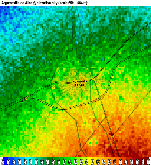
Below is the Elevation map of Argamasilla de Alba, which displays elevation range with different colors. Scale of the first map is from 659 to 684 m (2162 to 2244 ft) with average elevation of 670.3 meters (=2199 ft) [note 1]
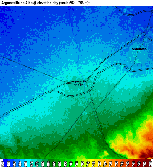
These maps also provides idea of topography and contour of this city, they are displayed at different zoom levels. More info about maps, scale and edge coordinates you can find below images.
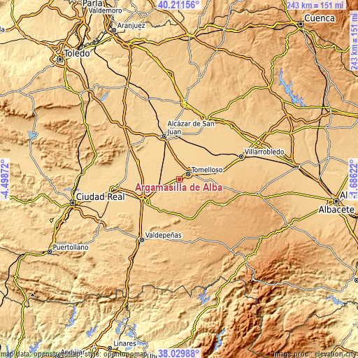
| \ | Map #1 | Map #2 | Topo.Map |
| Scale [m] | 659..684 m | 652..756 m | × |
| Scale [ft] | 2162..2244 ft | 2139..2480 ft | × |
| Average | 670.3 m = 2199 ft | 672.4 m = 2206 ft | × |
| Width | 7.58 km = 4.7 mi | 15.16 km = 9.4 mi | 242.6 km = 150.7 mi |
| Height | 7.58 km = 4.7 mi | 15.16 km = 9.4 mi | 242.6 km = 150.7 mi |
| ↑Max Latitude | 39.163251° | 39.197316° | 40.21156° |
| Latitude at center | 39.12917° | 39.12917° | 39.12917° |
| ↓Min Latitude | 39.095072° | 39.060958° | 38.02988° |
| ← Min Longitude | -3.136415° | -3.180361° | -4.49872° |
| Longitude center | -3.09247° | -3.09247° | -3.09247° |
| →Max Longitude | -3.048525° | -3.004579° | -1.68622° |
Nearby cities:
Cities around Argamasilla de Alba sort by population:
• Tomelloso elevation 669 m
6.9 km,  62°
62°
• Alcázar de San Juan 649 m
30.7 km,  341°
341°
• Manzanares 666 m
28 km,  238°
238°
• La Solana 765 m
24.1 km,  211°
211°
• Campo de Criptana 711 m
30.8 km,  354°
354°
• Socuéllamos 682 m
31.2 km, 56°
• Pedro Muñoz 666 m
32.9 km,  22°
22°
• Membrilla 671 m
27.8 km,  231°
231°
• Villarta de San Juan 631 m
31 km,  292°
292°
• Carrizosa 825 m
33.1 km,  164°
164°
• Alhambra 861 m
25.8 km,  172°
172°
• Ruidera 787 m
24.7 km,  132°
132°
Multilingual:
 En español:
Argamasilla de Alba elevación 674 m.
 En France:
Argamasilla de Alba élévation 674 m.
 Auf Deutsch:
Argamasilla de Alba höhe über dem Meeresspiegel ist 674 m.
 На русском:
Argamasilla de Alba высота над уровнем моря 674 м
Sources and notes:
- [note 1] Map square and city borders are not equal. Map elevation data is calculated only from area inside that square.
- [src 1] Elevation data from geonames database provided with same terms of usage.
- [src 2] The elevation map of Argamasilla de Alba is generated using elevation data from NASA's 3 arcsec (90m) resolution SRTM data.
- [src 3] Base (background) map © OpenStreetMap contributors tiles are generated by Geofabrik and OpenTopoMap.
Copyright & License:
This Argamasilla de Alba Elevation Map is licensed under CC BY-SA. You may reuse any part from this page, if you give a proper credit by linking to this URL:
 More info on terms of use page.