Ruidera elevation
Ruidera (Castille-La Mancha, Provincia de Ciudad Real), Spain elevation is 787 meters and Ruidera elevation in feet is 2582 ft above sea level [src 1]. Ruidera is a seat of a third-order administrative division (feature code) with elevation that is 184 meters (604 ft) bigger than average city elevation in Spain.
Below is the Elevation map of Ruidera, which displays elevation range with different colors. Scale of the first map is from 740 to 930 m (2428 to 3051 ft) with average elevation of 849.2 meters (=2786 ft) [note 1]
These maps also provides idea of topography and contour of this city, they are displayed at different zoom levels. More info about maps, scale and edge coordinates you can find below images.
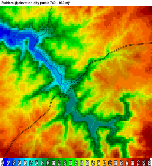
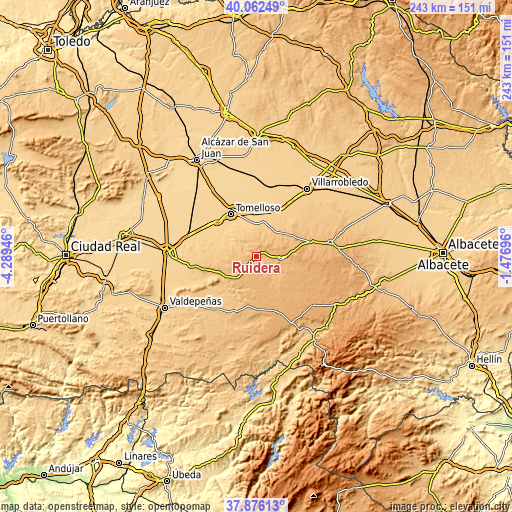
| \ | Map #1 | Topo.Map |
| Scale [m] | 740..930 m | × |
| Scale [ft] | 2428..3051 ft | × |
| Average | 849.2 m = 2786 ft | × |
| Width | 7.6 km = 4.7 mi | 243.1 km = 151.1 mi |
| Height | 7.6 km = 4.7 mi | 243.1 km = 151.1 mi |
| ↑Max Latitude | 39.011904° | 40.06249° |
| Latitude at center | 38.97775° | 38.97775° |
| ↓Min Latitude | 38.943579° | 37.87613° |
| ← Min Longitude | -2.927155° | -4.28946° |
| Longitude center | -2.88321° | -2.88321° |
| →Max Longitude | -2.839265° | -1.47696° |
Nearby cities:
Cities around Ruidera sort by population:
• Tomelloso elevation 669 m
23.3 km,  329°
329°
• La Solana 765 m
30.9 km,  263°
263°
• Argamasilla de Alba 674 m
24.7 km,  312°
312°
• Infantes 885 m
29 km,  202°
202°
• El Bonillo 1069 m
29.8 km,  95°
95°
• Ossa de Montiel 914 m
12 km, 97°
• Villahermosa 959 m
25.3 km,  177°
177°
• Montiel 894 m
31.1 km, 177°
• Carrizosa 825 m
17.8 km,  212°
212°
• Alhambra 861 m
17.1 km,  239°
239°
• Alcubillas 810 m
33.1 km,  221°
221°
• Fuenllana 910 m
25.5 km,  194°
194°
Multilingual:
 En español:
Ruidera elevación 787 m.
 En France:
Ruidera élévation 787 m.


Sources and notes:
- [note 1] Map square and city borders are not equal. Map elevation data is calculated only from area inside that square.
- [src 1] Elevation data from geonames database provided with same terms of usage.
- [src 2] The elevation map of Ruidera is generated using elevation data from NASA's 3 arcsec (90m) resolution SRTM data.
- [src 3] Base (background) map © OpenStreetMap contributors tiles are generated by Geofabrik and OpenTopoMap.
Copyright & License:
This Ruidera Elevation Map is licensed under CC BY-SA. You may reuse any part from this page, if you give a proper credit by linking to this URL:
 More info on terms of use page.