Aroche elevation
Aroche (Andalusia, Provincia de Huelva), Spain elevation is 388 meters and Aroche elevation in feet is 1273 ft above sea level [src 1]. Aroche is a seat of a third-order administrative division (feature code) with elevation that is 215 meters (705 ft) smaller than average city elevation in Spain.
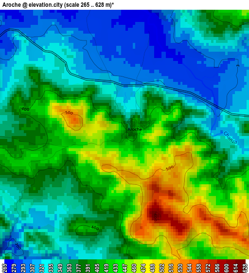
Below is the Elevation map of Aroche, which displays elevation range with different colors. Scale of the first map is from 265 to 628 m (869 to 2060 ft) with average elevation of 380.9 meters (=1250 ft) [note 1]
These maps also provides idea of topography and contour of this city, they are displayed at different zoom levels. More info about maps, scale and edge coordinates you can find below images.
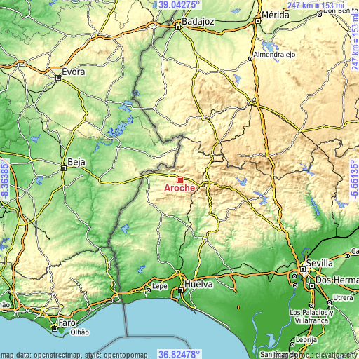
| \ | Map #1 | Topo.Map |
| Scale [m] | 265..628 m | × |
| Scale [ft] | 869..2060 ft | × |
| Average | 380.9 m = 1250 ft | × |
| Width | 7.71 km = 4.8 mi | 246.6 km = 153.2 mi |
| Height | 7.71 km = 4.8 mi | 246.6 km = 153.2 mi |
| ↑Max Latitude | 37.976779° | 39.04275° |
| Latitude at center | 37.94213° | 37.94213° |
| ↓Min Latitude | 37.907465° | 36.82478° |
| ← Min Longitude | -7.001545° | -8.36385° |
| Longitude center | -6.9576° | -6.9576° |
| →Max Longitude | -6.913655° | -5.55135° |
Nearby cities:
Cities around Aroche sort by population:
• El Cerro de Andévalo elevation 308 m
23.1 km,  175°
175°
• Rosal de la Frontera 223 m
23.1 km,  277°
277°
• Cabezas Rubias 222 m
26.5 km,  205°
205°
• Alájar 580 m
26.7 km,  106°
106°
• Fuenteheridos 716 m
26.3 km,  98°
98°
• Santa Bárbara de Casa 311 m
25.9 km,  231°
231°
• Valdelarco 624 m
24.2 km,  88°
88°
• Encinasola 428 m
22.8 km,  20°
20°
• Santa Ana la Real 641 m
22.3 km, 113°
• Galaroza 577 m
22 km, 93°
• Jabugo 658 m
20.2 km, 98°
• Cortegana 673 m
12.5 km, 105°
Multilingual:
 En español:
Aroche elevación 388 m.
 En France:
Aroche élévation 388 m.


Sources and notes:
- [note 1] Map square and city borders are not equal. Map elevation data is calculated only from area inside that square.
- [src 1] Elevation data from geonames database provided with same terms of usage.
- [src 2] The elevation map of Aroche is generated using elevation data from NASA's 3 arcsec (90m) resolution SRTM data.
- [src 3] Base (background) map © OpenStreetMap contributors tiles are generated by Geofabrik and OpenTopoMap.
Copyright & License:
This Aroche Elevation Map is licensed under CC BY-SA. You may reuse any part from this page, if you give a proper credit by linking to this URL:
 More info on terms of use page.