Atarfe elevation
Atarfe (Andalusia, Provincia de Granada), Spain elevation is 613 meters and Atarfe elevation in feet is 2011 ft above sea level [src 1]. Atarfe is a seat of a third-order administrative division (feature code) with elevation that is 10 meters (33 ft) bigger than average city elevation in Spain.
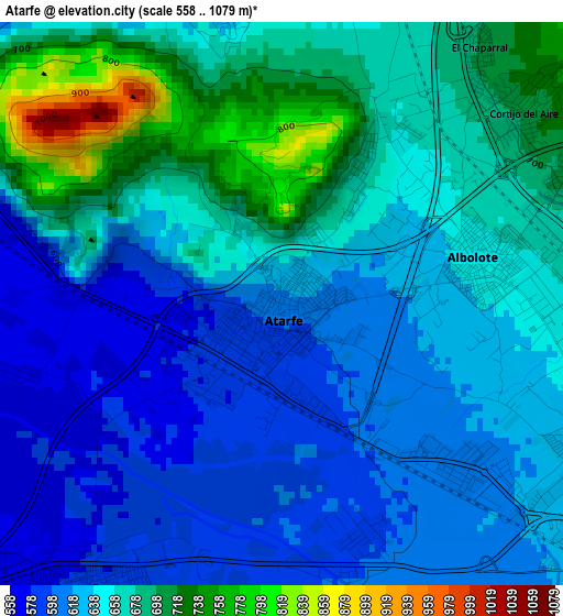
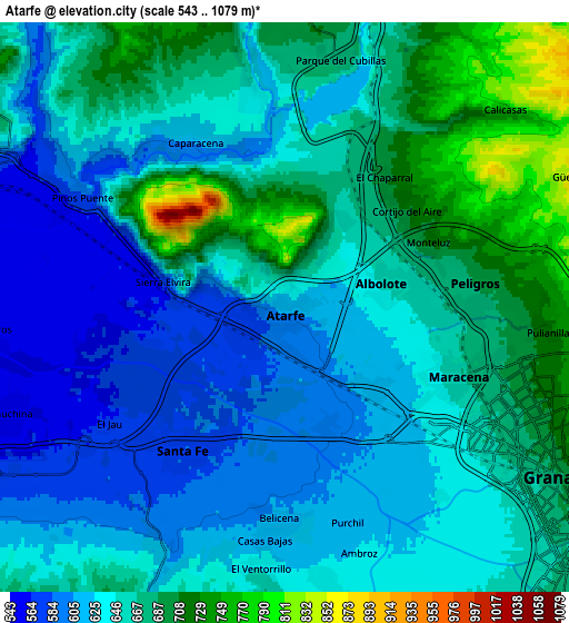
Below is the Elevation map of Atarfe, which displays elevation range with different colors. Scale of the first map is from 558 to 1079 m (1831 to 3540 ft) with average elevation of 648.2 meters (=2127 ft) [note 1]
These maps also provides idea of topography and contour of this city, they are displayed at different zoom levels. More info about maps, scale and edge coordinates you can find below images.
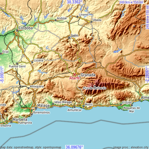
| \ | Map #1 | Map #2 | Topo.Map |
| Scale [m] | 558..1079 m | 543..1079 m | × |
| Scale [ft] | 1831..3540 ft | 1781..3540 ft | × |
| Average | 648.2 m = 2127 ft | 650.5 m = 2134 ft | × |
| Width | 7.78 km = 4.8 mi | 15.56 km = 9.7 mi | 249 km = 154.7 mi |
| Height | 7.78 km = 4.8 mi | 15.56 km = 9.7 mi | 249 km = 154.7 mi |
| ↑Max Latitude | 37.259774° | 37.294742° | 38.3362° |
| Latitude at center | 37.22479° | 37.22479° | 37.22479° |
| ↓Min Latitude | 37.18979° | 37.154773° | 36.09676° |
| ← Min Longitude | -3.730805° | -3.774751° | -5.09311° |
| Longitude center | -3.68686° | -3.68686° | -3.68686° |
| →Max Longitude | -3.642915° | -3.598969° | -2.28061° |
Nearby cities:
Cities around Atarfe sort by population:
• Granada elevation 689 m
8.2 km,  119°
119°
• Maracena 662 m
5 km,  112°
112°
• Albolote 654 m
2.9 km,  76°
76°
• Santafé 582 m
4.9 km,  215°
215°
• Pinos Puente 573 m
6.3 km,  297°
297°
• Peligros 693 m
5.2 km, 80°
• Cúllar-Vega 643 m
8 km,  169°
169°
• Pulianas 727 m
7 km,  91°
91°
• Chauchina 553 m
8 km,  249°
249°
• Fuente Vaqueros 546 m
8.5 km,  266°
266°
• Calicasas 759 m
8.3 km,  51°
51°
• Jun 767 m
8.2 km, 93°
Multilingual:
 En español:
Atarfe elevación 613 m.
 En France:
Atarfe élévation 613 m.


Sources and notes:
- [note 1] Map square and city borders are not equal. Map elevation data is calculated only from area inside that square.
- [src 1] Elevation data from geonames database provided with same terms of usage.
- [src 2] The elevation map of Atarfe is generated using elevation data from NASA's 3 arcsec (90m) resolution SRTM data.
- [src 3] Base (background) map © OpenStreetMap contributors tiles are generated by Geofabrik and OpenTopoMap.
Copyright & License:
This Atarfe Elevation Map is licensed under CC BY-SA. You may reuse any part from this page, if you give a proper credit by linking to this URL:
 More info on terms of use page.