Aznalcóllar elevation
Aznalcóllar (Andalusia, Provincia de Sevilla), Spain elevation is 126 meters and Aznalcóllar elevation in feet is 413 ft above sea level [src 1]. Aznalcóllar is a seat of a third-order administrative division (feature code) with elevation that is 477 meters (1565 ft) smaller than average city elevation in Spain.
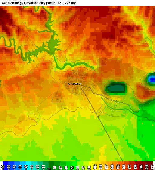
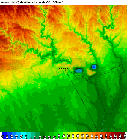
Below is the Elevation map of Aznalcóllar, which displays elevation range with different colors. Scale of the first map is from -98 to 227 m (-322 to 745 ft) with average elevation of 115.5 meters (=379 ft) [note 1]
These maps also provides idea of topography and contour of this city, they are displayed at different zoom levels. More info about maps, scale and edge coordinates you can find below images.

| \ | Map #1 | Map #2 | Topo.Map |
| Scale [m] | -98..227 m | -98..330 m | × |
| Scale [ft] | -322..745 ft | -322..1083 ft | × |
| Average | 115.5 m = 379 ft | 125 m = 410 ft | × |
| Width | 7.75 km = 4.8 mi | 15.5 km = 9.6 mi | 248 km = 154.1 mi |
| Height | 7.75 km = 4.8 mi | 15.5 km = 9.6 mi | 248 km = 154.1 mi |
| ↑Max Latitude | 37.553987° | 37.588818° | 38.62614° |
| Latitude at center | 37.51914° | 37.51914° | 37.51914° |
| ↓Min Latitude | 37.484277° | 37.449397° | 36.39547° |
| ← Min Longitude | -6.313825° | -6.357771° | -7.67613° |
| Longitude center | -6.26988° | -6.26988° | -6.26988° |
| →Max Longitude | -6.225935° | -6.181989° | -4.86363° |
Nearby cities:
Cities around Aznalcóllar sort by population:
• Sanlúcar la Mayor elevation 141 m
15.8 km,  158°
158°
• Guillena 25 m
19 km,  82°
82°
• Olivares 175 m
15.1 km,  138°
138°
• Gerena 87 m
10.2 km, 83°
• Umbrete 122 m
19.4 km,  149°
149°
• Villanueva del Ariscal 153 m
17.8 km, 140°
• Salteras 156 m
17.8 km,  127°
127°
• Paterna del Campo 175 m
16.1 km,  226°
226°
• Carrión de los Céspedes 99 m
17.4 km,  197°
197°
• Albaida del Aljarafe 173 m
14 km, 139°
• Escacena del Campo 163 m
16.2 km,  220°
220°
• Castilleja del Campo 111 m
15.8 km, 201°
Multilingual:
 En español:
Aznalcóllar elevación 126 m.
 En France:
Aznalcóllar élévation 126 m.
 Auf Deutsch:
Aznalcóllar höhe über dem Meeresspiegel ist 126 m.

Sources and notes:
- [note 1] Map square and city borders are not equal. Map elevation data is calculated only from area inside that square.
- [src 1] Elevation data from geonames database provided with same terms of usage.
- [src 2] The elevation map of Aznalcóllar is generated using elevation data from NASA's 3 arcsec (90m) resolution SRTM data.
- [src 3] Base (background) map © OpenStreetMap contributors tiles are generated by Geofabrik and OpenTopoMap.
Copyright & License:
This Aznalcóllar Elevation Map is licensed under CC BY-SA. You may reuse any part from this page, if you give a proper credit by linking to this URL:
 More info on terms of use page.