Berrocalejo elevation
Berrocalejo (Extremadura, Provincia de Cáceres), Spain elevation is 376 meters and Berrocalejo elevation in feet is 1234 ft above sea level [src 1]. Berrocalejo is a seat of a third-order administrative division (feature code) with elevation that is 227 meters (745 ft) smaller than average city elevation in Spain.
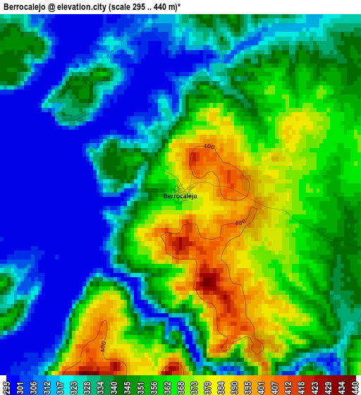
Below is the Elevation map of Berrocalejo, which displays elevation range with different colors. Scale of the first map is from 295 to 440 m (968 to 1444 ft) with average elevation of 344.1 meters (=1129 ft) [note 1]
These maps also provides idea of topography and contour of this city, they are displayed at different zoom levels. More info about maps, scale and edge coordinates you can find below images.
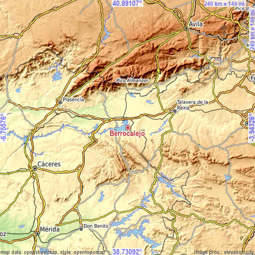
| \ | Map #1 | Topo.Map |
| Scale [m] | 295..440 m | × |
| Scale [ft] | 968..1444 ft | × |
| Average | 344.1 m = 1129 ft | × |
| Width | 7.51 km = 4.7 mi | 240.2 km = 149.3 mi |
| Height | 7.51 km = 4.7 mi | 240.2 km = 149.3 mi |
| ↑Max Latitude | 39.853225° | 40.89107° |
| Latitude at center | 39.81948° | 39.81948° |
| ↓Min Latitude | 39.785719° | 38.73092° |
| ← Min Longitude | -5.393455° | -6.75576° |
| Longitude center | -5.34951° | -5.34951° |
| →Max Longitude | -5.305565° | -3.94326° |
Nearby cities:
Cities around Berrocalejo sort by population:
• Lagartera elevation 396 m
15.9 km,  52°
52°
• Peraleda de la Mata 343 m
10.2 km,  291°
291°
• El Puente del Arzobispo 340 m
15.3 km,  97°
97°
• Torrico 441 m
10.6 km,  84°
84°
• Valdeverdeja 475 m
9.3 km,  106°
106°
• Bohonal de Ibor 355 m
12.2 km,  251°
251°
• Herreruela de Oropesa 380 m
12 km, 49°
• Valdelacasa de Tajo 459 m
11.9 km,  151°
151°
• Peraleda de San Román 472 m
9.3 km,  200°
200°
• Caleruela 373 m
10 km, 52°
• Valdehúncar 372 m
14.9 km,  277°
277°
• Garvín 502 m
11.1 km,  178°
178°
Multilingual:
 En español:
Berro del Calejo elevación 376 m.
 En France:
Berrocalejo élévation 376 m.
 Auf Deutsch:
Berrocalejo höhe über dem Meeresspiegel ist 376 m.

Sources and notes:
- [note 1] Map square and city borders are not equal. Map elevation data is calculated only from area inside that square.
- [src 1] Elevation data from geonames database provided with same terms of usage.
- [src 2] The elevation map of Berrocalejo is generated using elevation data from NASA's 3 arcsec (90m) resolution SRTM data.
- [src 3] Base (background) map © OpenStreetMap contributors tiles are generated by Geofabrik and OpenTopoMap.
Copyright & License:
This Berrocalejo Elevation Map is licensed under CC BY-SA. You may reuse any part from this page, if you give a proper credit by linking to this URL:
 More info on terms of use page.