Garvín elevation
Garvín (Extremadura, Provincia de Cáceres), Spain elevation is 502 meters and Garvín elevation in feet is 1647 ft above sea level [src 1]. Garvín is a seat of a third-order administrative division (feature code) with elevation that is 101 meters (331 ft) smaller than average city elevation in Spain.
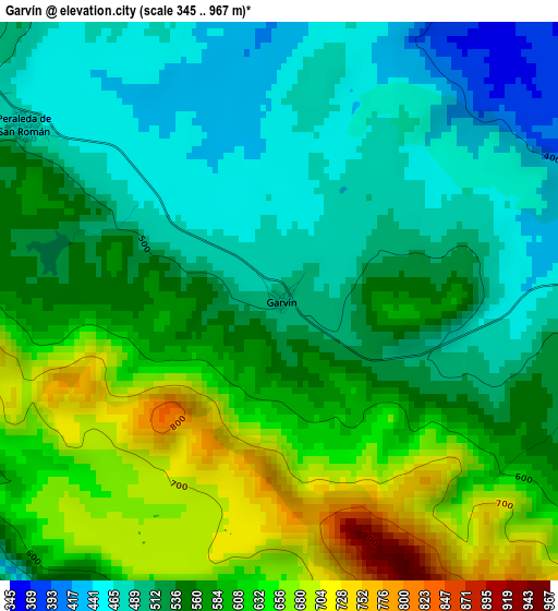
Below is the Elevation map of Garvín, which displays elevation range with different colors. Scale of the first map is from 345 to 967 m (1132 to 3173 ft) with average elevation of 557.6 meters (=1829 ft) [note 1]
These maps also provides idea of topography and contour of this city, they are displayed at different zoom levels. More info about maps, scale and edge coordinates you can find below images.
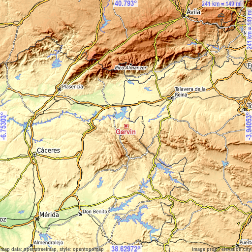
| \ | Map #1 | Topo.Map |
| Scale [m] | 345..967 m | × |
| Scale [ft] | 1132..3173 ft | × |
| Average | 557.6 m = 1829 ft | × |
| Width | 7.52 km = 4.7 mi | 240.5 km = 149.4 mi |
| Height | 7.52 km = 4.7 mi | 240.5 km = 149.4 mi |
| ↑Max Latitude | 39.753633° | 40.793° |
| Latitude at center | 39.71984° | 39.71984° |
| ↓Min Latitude | 39.68603° | 38.62972° |
| ← Min Longitude | -5.390725° | -6.75303° |
| Longitude center | -5.34678° | -5.34678° |
| →Max Longitude | -5.302835° | -3.94053° |
Nearby cities:
Cities around Garvín sort by population:
• El Puente del Arzobispo elevation 340 m
17.5 km,  58°
58°
• Castañar de Ibor 650 m
11.8 km,  210°
210°
• Torrico 441 m
16 km,  40°
40°
• Villar del Pedroso 495 m
13 km,  96°
96°
• Valdeverdeja 475 m
12.1 km,  45°
45°
• Bohonal de Ibor 355 m
13.8 km,  301°
301°
• Valdelacasa de Tajo 459 m
5.5 km,  82°
82°
• Navalvillar de Ibor 677 m
16.2 km,  200°
200°
• Fresnedoso de Ibor 516 m
14.4 km,  254°
254°
• Peraleda de San Román 472 m
4.2 km, 304°
• Berrocalejo 376 m
11.1 km,  358°
358°
• Carrascalejo 633 m
14.7 km,  130°
130°
Multilingual:
 En español:
Garvín elevación 502 m.
 En France:
Garvín élévation 502 m.


Sources and notes:
- [note 1] Map square and city borders are not equal. Map elevation data is calculated only from area inside that square.
- [src 1] Elevation data from geonames database provided with same terms of usage.
- [src 2] The elevation map of Garvín is generated using elevation data from NASA's 3 arcsec (90m) resolution SRTM data.
- [src 3] Base (background) map © OpenStreetMap contributors tiles are generated by Geofabrik and OpenTopoMap.
Copyright & License:
This Garvín Elevation Map is licensed under CC BY-SA. You may reuse any part from this page, if you give a proper credit by linking to this URL:
 More info on terms of use page.