Bujalance elevation
Bujalance (Andalusia, Province of Córdoba), Spain elevation is 338 meters and Bujalance elevation in feet is 1109 ft above sea level [src 1]. Bujalance is a seat of a third-order administrative division (feature code) with elevation that is 265 meters (869 ft) smaller than average city elevation in Spain.
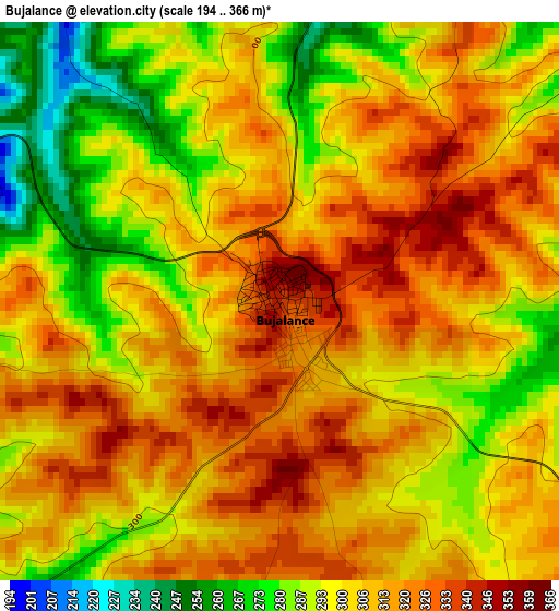
Below is the Elevation map of Bujalance, which displays elevation range with different colors. Scale of the first map is from 194 to 366 m (636 to 1201 ft) with average elevation of 305.3 meters (=1002 ft) [note 1]
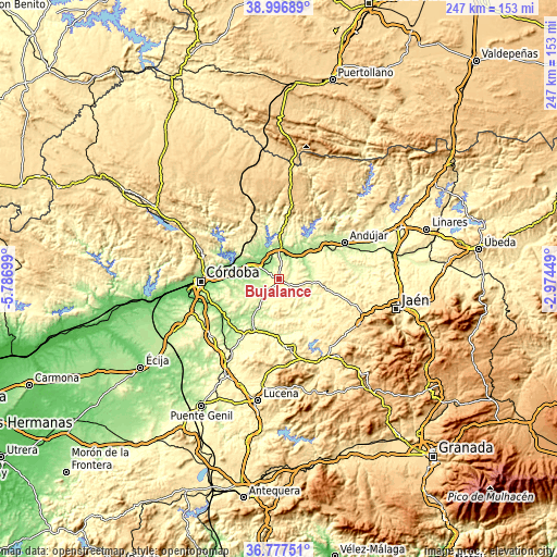
These maps also provides idea of topography and contour of this city, they are displayed at different zoom levels. More info about maps, scale and edge coordinates you can find below images.

| \ | Map #1 | Map #2 | Topo.Map |
| Scale [m] | 194..366 m | 126..412 m | × |
| Scale [ft] | 636..1201 ft | 413..1352 ft | × |
| Average | 305.3 m = 1002 ft | 276.2 m = 906 ft | × |
| Width | 7.71 km = 4.8 mi | 15.42 km = 9.6 mi | 246.8 km = 153.4 mi |
| Height | 7.71 km = 4.8 mi | 15.42 km = 9.6 mi | 246.8 km = 153.4 mi |
| ↑Max Latitude | 37.93023° | 37.964885° | 38.99689° |
| Latitude at center | 37.89556° | 37.89556° | 37.89556° |
| ↓Min Latitude | 37.860873° | 37.82617° | 36.77751° |
| ← Min Longitude | -4.424685° | -4.468631° | -5.78699° |
| Longitude center | -4.38074° | -4.38074° | -4.38074° |
| →Max Longitude | -4.336795° | -4.292849° | -2.97449° |
Nearby cities:
Cities around Bujalance sort by population:
• Montoro elevation 195 m
14.3 km,  359°
359°
• Villa del Río 168 m
12.4 km,  39°
39°
• Porcuna 472 m
17.4 km,  99°
99°
• El Carpio 163 m
11.4 km,  296°
296°
• Adamuz 237 m
19.2 km,  319°
319°
• Lopera 266 m
15.6 km,  69°
69°
• Villafranca de Córdoba 143 m
16.3 km, 297°
• Cañete de las Torres 322 m
6.3 km,  119°
119°
• Pedro Abad 159 m
10.3 km, 320°
• Valenzuela 327 m
19.4 km,  133°
133°
• Santiago de Calatrava 397 m
24.2 km, 130°
• Higuera de Calatrava 356 m
22.4 km, 118°
Multilingual:
 En español:
Bujalance elevación 338 m.
 En France:
Bujalance élévation 338 m.
 Auf Deutsch:
Bujalance höhe über dem Meeresspiegel ist 338 m.

Sources and notes:
- [note 1] Map square and city borders are not equal. Map elevation data is calculated only from area inside that square.
- [src 1] Elevation data from geonames database provided with same terms of usage.
- [src 2] The elevation map of Bujalance is generated using elevation data from NASA's 3 arcsec (90m) resolution SRTM data.
- [src 3] Base (background) map © OpenStreetMap contributors tiles are generated by Geofabrik and OpenTopoMap.
Copyright & License:
This Bujalance Elevation Map is licensed under CC BY-SA. You may reuse any part from this page, if you give a proper credit by linking to this URL:
 More info on terms of use page.