Cabezarados elevation
Cabezarados (Castille-La Mancha, Provincia de Ciudad Real), Spain elevation is 685 meters and Cabezarados elevation in feet is 2247 ft above sea level [src 1]. Cabezarados is a seat of a third-order administrative division (feature code) with elevation that is 82 meters (269 ft) bigger than average city elevation in Spain.
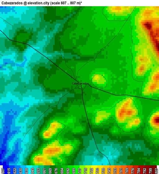
Below is the Elevation map of Cabezarados, which displays elevation range with different colors. Scale of the first map is from 607 to 807 m (1991 to 2648 ft) with average elevation of 679.7 meters (=2230 ft) [note 1]
These maps also provides idea of topography and contour of this city, they are displayed at different zoom levels. More info about maps, scale and edge coordinates you can find below images.
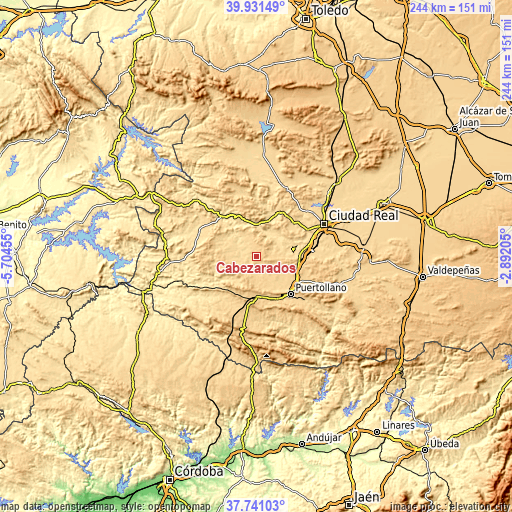
| \ | Map #1 | Topo.Map |
| Scale [m] | 607..807 m | × |
| Scale [ft] | 1991..2648 ft | × |
| Average | 679.7 m = 2230 ft | × |
| Width | 7.61 km = 4.7 mi | 243.6 km = 151.4 mi |
| Height | 7.61 km = 4.7 mi | 243.6 km = 151.4 mi |
| ↑Max Latitude | 38.878909° | 39.93149° |
| Latitude at center | 38.84469° | 38.84469° |
| ↓Min Latitude | 38.810455° | 37.74103° |
| ← Min Longitude | -4.342245° | -5.70455° |
| Longitude center | -4.2983° | -4.2983° |
| →Max Longitude | -4.254355° | -2.89205° |
Nearby cities:
Cities around Cabezarados sort by population:
• Puertollano elevation 701 m
24.1 km,  136°
136°
• Almodóvar del Campo 675 m
18.3 km,  145°
145°
• Argamasilla de Calatrava 668 m
23.1 km,  123°
123°
• Piedrabuena 594 m
23.7 km,  26°
26°
• Abenójar 615 m
6.4 km,  307°
307°
• Alcolea de Calatrava 653 m
22.3 km,  44°
44°
• Corral de Calatrava 596 m
18.8 km,  85°
85°
• Brazatortas 729 m
20.7 km,  178°
178°
• Saceruela 591 m
29 km,  292°
292°
• Villamayor de Calatrava 661 m
15.3 km,  114°
114°
• Villar del Pozo 639 m
29 km, 88°
• Cañada de Calatrava 650 m
24 km, 87°
Multilingual:
 En español:
Cabezarados elevación 685 m.
 En France:
Cabezarados élévation 685 m.
 Auf Deutsch:
Cabezarados höhe über dem Meeresspiegel ist 685 m.

Sources and notes:
- [note 1] Map square and city borders are not equal. Map elevation data is calculated only from area inside that square.
- [src 1] Elevation data from geonames database provided with same terms of usage.
- [src 2] The elevation map of Cabezarados is generated using elevation data from NASA's 3 arcsec (90m) resolution SRTM data.
- [src 3] Base (background) map © OpenStreetMap contributors tiles are generated by Geofabrik and OpenTopoMap.
Copyright & License:
This Cabezarados Elevation Map is licensed under CC BY-SA. You may reuse any part from this page, if you give a proper credit by linking to this URL:
 More info on terms of use page.