Campillo de Deleitosa elevation
Campillo de Deleitosa (Extremadura, Provincia de Cáceres), Spain elevation is 501 meters and Campillo de Deleitosa elevation in feet is 1644 ft above sea level [src 1]. Campillo de Deleitosa is a seat of a third-order administrative division (feature code) with elevation that is 102 meters (335 ft) smaller than average city elevation in Spain.
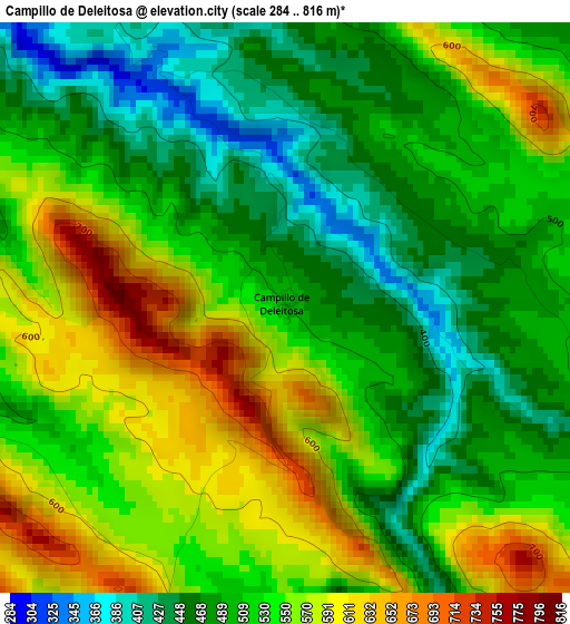
Below is the Elevation map of Campillo de Deleitosa, which displays elevation range with different colors. Scale of the first map is from 284 to 816 m (932 to 2677 ft) with average elevation of 525.1 meters (=1723 ft) [note 1]
These maps also provides idea of topography and contour of this city, they are displayed at different zoom levels. More info about maps, scale and edge coordinates you can find below images.
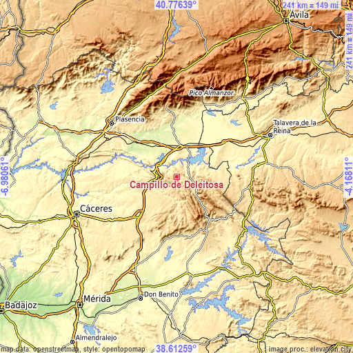
| \ | Map #1 | Topo.Map |
| Scale [m] | 284..816 m | × |
| Scale [ft] | 932..2677 ft | × |
| Average | 525.1 m = 1723 ft | × |
| Width | 7.52 km = 4.7 mi | 240.6 km = 149.5 mi |
| Height | 7.52 km = 4.7 mi | 240.6 km = 149.5 mi |
| ↑Max Latitude | 39.736772° | 40.77639° |
| Latitude at center | 39.70297° | 39.70297° |
| ↓Min Latitude | 39.669152° | 38.61259° |
| ← Min Longitude | -5.618305° | -6.98061° |
| Longitude center | -5.57436° | -5.57436° |
| →Max Longitude | -5.530415° | -4.16811° |
Nearby cities:
Cities around Campillo de Deleitosa sort by population:
• Almaraz elevation 273 m
15.2 km,  324°
324°
• Castañar de Ibor 650 m
15.8 km,  121°
121°
• Deleitosa 567 m
9 km,  222°
222°
• Bohonal de Ibor 355 m
11.9 km,  40°
40°
• Robledollano 713 m
11.8 km,  151°
151°
• Fresnedoso de Ibor 516 m
6 km,  110°
110°
• Valdehúncar 372 m
15.5 km,  16°
16°
• Mesas de Ibor 486 m
6.4 km, 22°
• Valdecañas de Tajo 371 m
7.3 km,  328°
328°
• Casas de Miravete 449 m
14.7 km,  280°
280°
• Romangordo 422 m
11.7 km,  291°
291°
• Higuera 477 m
8.3 km, 287°
Multilingual:
 En español:
Campillo de Deleitosa elevación 501 m.
 En France:
Campillo de Deleitosa élévation 501 m.
 Auf Deutsch:
Campillo de Deleitosa höhe über dem Meeresspiegel ist 501 m.
 На русском:
Campillo de Deleitosa высота над уровнем моря 501 м
Sources and notes:
- [note 1] Map square and city borders are not equal. Map elevation data is calculated only from area inside that square.
- [src 1] Elevation data from geonames database provided with same terms of usage.
- [src 2] The elevation map of Campillo de Deleitosa is generated using elevation data from NASA's 3 arcsec (90m) resolution SRTM data.
- [src 3] Base (background) map © OpenStreetMap contributors tiles are generated by Geofabrik and OpenTopoMap.
Copyright & License:
This Campillo de Deleitosa Elevation Map is licensed under CC BY-SA. You may reuse any part from this page, if you give a proper credit by linking to this URL:
 More info on terms of use page.