Cañada del Hoyo elevation
Cañada del Hoyo (Castille-La Mancha, Provincia de Cuenca), Spain elevation is 1001 meters and Cañada del Hoyo elevation in feet is 3284 ft above sea level [src 1]. Cañada del Hoyo is a seat of a third-order administrative division (feature code) with elevation that is 398 meters (1306 ft) bigger than average city elevation in Spain.
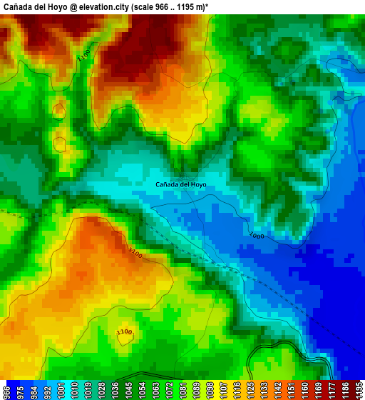
Below is the Elevation map of Cañada del Hoyo, which displays elevation range with different colors. Scale of the first map is from 966 to 1195 m (3169 to 3921 ft) with average elevation of 1059.4 meters (=3476 ft) [note 1]
These maps also provides idea of topography and contour of this city, they are displayed at different zoom levels. More info about maps, scale and edge coordinates you can find below images.
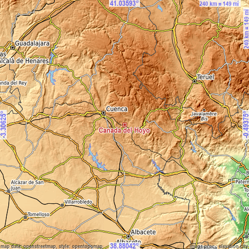
| \ | Map #1 | Topo.Map |
| Scale [m] | 966..1195 m | × |
| Scale [ft] | 3169..3921 ft | × |
| Average | 1059.4 m = 3476 ft | × |
| Width | 7.49 km = 4.7 mi | 239.7 km = 148.9 mi |
| Height | 7.49 km = 4.7 mi | 239.7 km = 148.9 mi |
| ↑Max Latitude | 40.000342° | 41.03593° |
| Latitude at center | 39.96667° | 39.96667° |
| ↓Min Latitude | 39.932981° | 38.88042° |
| ← Min Longitude | -1.943945° | -3.30625° |
| Longitude center | -1.9° | -1.9° |
| →Max Longitude | -1.856055° | -0.49375° |
Nearby cities:
Cities around Cañada del Hoyo sort by population:
• Cuenca elevation 941 m
22.8 km,  299°
299°
• Carboneras de Guadazaón 1083 m
12.6 km,  137°
137°
• Cañete 1180 m
23.2 km,  66°
66°
• Fuentes 1053 m
9.9 km,  270°
270°
• Valdemoro-Sierra 1111 m
18.7 km,  37°
37°
• Monteagudo de las Salinas 948 m
18.5 km,  180°
180°
• Arguisuelas 1028 m
16.4 km,  154°
154°
• Reíllo 974 m
7.9 km,  159°
159°
• Pajarón 1055 m
10.1 km,  100°
100°
• Pajaroncillo 975 m
14.3 km, 97°
• Valdemorillo de la Sierra 1130 m
12.4 km,  53°
53°
• Campillos-Sierra 1279 m
22.6 km, 48°
Multilingual:
 En español:
Cañada del Hoyo elevación 1001 m.
 En France:
Cañada del Hoyo élévation 1001 m.
 Auf Deutsch:
Cañada del Hoyo höhe über dem Meeresspiegel ist 1001 m.

Sources and notes:
- [note 1] Map square and city borders are not equal. Map elevation data is calculated only from area inside that square.
- [src 1] Elevation data from geonames database provided with same terms of usage.
- [src 2] The elevation map of Cañada del Hoyo is generated using elevation data from NASA's 3 arcsec (90m) resolution SRTM data.
- [src 3] Base (background) map © OpenStreetMap contributors tiles are generated by Geofabrik and OpenTopoMap.
Copyright & License:
This Cañada del Hoyo Elevation Map is licensed under CC BY-SA. You may reuse any part from this page, if you give a proper credit by linking to this URL:
 More info on terms of use page.