Cañete elevation
Cañete (Castille-La Mancha, Provincia de Cuenca), Spain elevation is 1180 meters and Cañete elevation in feet is 3871 ft above sea level [src 1]. Cañete is a seat of a third-order administrative division (feature code) with elevation that is 577 meters (1893 ft) bigger than average city elevation in Spain.
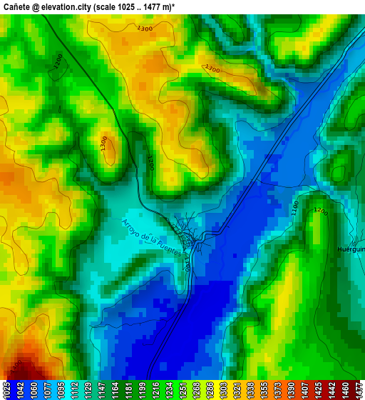
Below is the Elevation map of Cañete, which displays elevation range with different colors. Scale of the first map is from 1025 to 1477 m (3363 to 4846 ft) with average elevation of 1187.7 meters (=3897 ft) [note 1]
These maps also provides idea of topography and contour of this city, they are displayed at different zoom levels. More info about maps, scale and edge coordinates you can find below images.
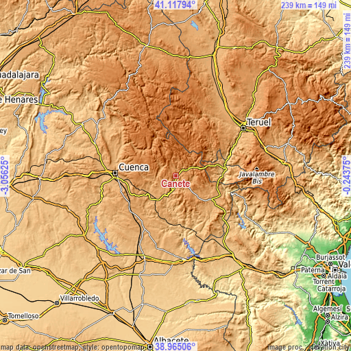
| \ | Map #1 | Topo.Map |
| Scale [m] | 1025..1477 m | × |
| Scale [ft] | 3363..4846 ft | × |
| Average | 1187.7 m = 3897 ft | × |
| Width | 7.48 km = 4.6 mi | 239.4 km = 148.8 mi |
| Height | 7.48 km = 4.6 mi | 239.4 km = 148.8 mi |
| ↑Max Latitude | 40.083631° | 41.11794° |
| Latitude at center | 40.05° | 40.05° |
| ↓Min Latitude | 40.016352° | 38.96506° |
| ← Min Longitude | -1.693945° | -3.05625° |
| Longitude center | -1.65° | -1.65° |
| →Max Longitude | -1.606055° | -0.24375° |
Nearby cities:
Cities around Cañete sort by population:
• Salvacañete elevation 1179 m
13.9 km,  66°
66°
• Huerta del Marquesado 1281 m
11.5 km,  345°
345°
• Tejadillos 1210 m
9.4 km,  8°
8°
• Valdemoro-Sierra 1111 m
11.4 km,  299°
299°
• Boniches 1048 m
7.9 km,  159°
159°
• Alcalá de la Vega 1103 m
11.5 km,  99°
99°
• Campillos-Paravientos 1091 m
11.3 km,  131°
131°
• Salinas del Manzano 1186 m
9.3 km, 66°
• Pajaroncillo 975 m
13.2 km,  212°
212°
• Huérguina 1254 m
4.6 km,  113°
113°
• Valdemorillo de la Sierra 1130 m
11.5 km,  260°
260°
• Campillos-Sierra 1279 m
7 km,  322°
322°
Multilingual:
 En español:
Cañete elevación 1180 m.
 En France:
Cañete élévation 1180 m.


Sources and notes:
- [note 1] Map square and city borders are not equal. Map elevation data is calculated only from area inside that square.
- [src 1] Elevation data from geonames database provided with same terms of usage.
- [src 2] The elevation map of Cañete is generated using elevation data from NASA's 3 arcsec (90m) resolution SRTM data.
- [src 3] Base (background) map © OpenStreetMap contributors tiles are generated by Geofabrik and OpenTopoMap.
Copyright & License:
This Cañete Elevation Map is licensed under CC BY-SA. You may reuse any part from this page, if you give a proper credit by linking to this URL:
 More info on terms of use page.