Esporles elevation
Esporles (Balearic Islands, Illes Balears), Spain elevation is 188 meters and Esporles elevation in feet is 617 ft above sea level [src 1]. Esporles is a seat of a third-order administrative division (feature code) with elevation that is 415 meters (1362 ft) smaller than average city elevation in Spain.
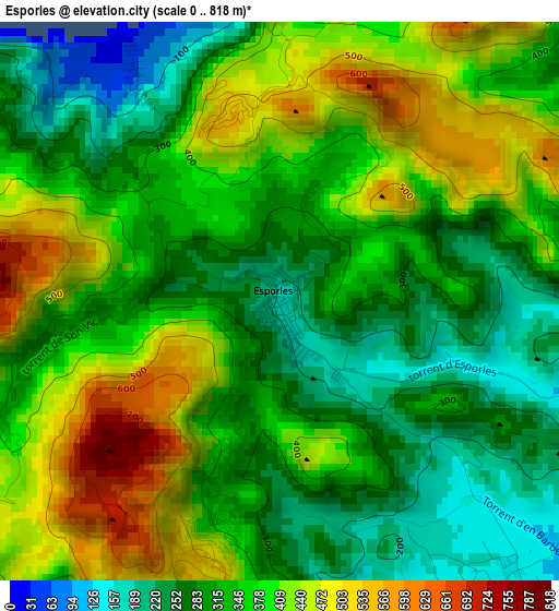
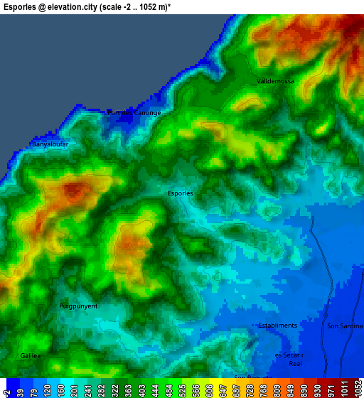
Below is the Elevation map of Esporles, which displays elevation range with different colors. Scale of the first map is from 0 to 818 m (0 to 2684 ft) with average elevation of 355.1 meters (=1165 ft) [note 1]
These maps also provides idea of topography and contour of this city, they are displayed at different zoom levels. More info about maps, scale and edge coordinates you can find below images.
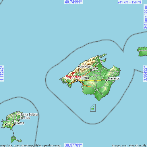
| \ | Map #1 | Map #2 | Topo.Map |
| Scale [m] | 0..818 m | -2..1052 m | × |
| Scale [ft] | 0..2684 ft | -7..3451 ft | × |
| Average | 355.1 m = 1165 ft | 332.6 m = 1091 ft | × |
| Width | 7.52 km = 4.7 mi | 15.04 km = 9.3 mi | 240.7 km = 149.6 mi |
| Height | 7.52 km = 4.7 mi | 15.04 km = 9.3 mi | 240.7 km = 149.6 mi |
| ↑Max Latitude | 39.701759° | 39.735561° | 40.74191° |
| Latitude at center | 39.66794° | 39.66794° | 39.66794° |
| ↓Min Latitude | 39.634105° | 39.600252° | 38.57701° |
| ← Min Longitude | 2.534725° | 2.490779° | 1.17242° |
| Longitude center | 2.57867° | 2.57867° | 2.57867° |
| →Max Longitude | 2.622615° | 2.666561° | 3.98492° |
Nearby cities:
Cities around Esporles sort by population:
• Palma elevation 34 m
12.6 km,  150°
150°
• Calvià 125 m
13 km,  208°
208°
• Marratxí 72 m
13.6 km,  112°
112°
• Sóller 45 m
16 km,  46°
46°
• Es Molinar 4 m
14.4 km, 145°
• Palmanova 7 m
16.3 km,  191°
191°
• Bunyola 217 m
10.8 km,  73°
73°
• Valldemossa 412 m
6 km,  38°
38°
• Puigpunyent 227 m
6.5 km,  222°
222°
• Deià 183 m
10.7 km,  33°
33°
• Banyalbufar 110 m
5.9 km,  291°
291°
• Estellencs 151 m
8.5 km,  259°
259°
Multilingual:
 En español:
Esporles elevación 188 m.
 En France:
Esporles élévation 188 m.
 Auf Deutsch:
Esporles höhe über dem Meeresspiegel ist 188 m.

Sources and notes:
- [note 1] Map square and city borders are not equal. Map elevation data is calculated only from area inside that square.
- [src 1] Elevation data from geonames database provided with same terms of usage.
- [src 2] The elevation map of Esporles is generated using elevation data from NASA's 3 arcsec (90m) resolution SRTM data.
- [src 3] Base (background) map © OpenStreetMap contributors tiles are generated by Geofabrik and OpenTopoMap.
Copyright & License:
This Esporles Elevation Map is licensed under CC BY-SA. You may reuse any part from this page, if you give a proper credit by linking to this URL:
 More info on terms of use page.