Marratxí elevation
Marratxí (Balearic Islands, Illes Balears), Spain elevation is 72 meters and Marratxí elevation in feet is 236 ft above sea level [src 1]. Marratxí is a seat of a third-order administrative division (feature code) with elevation that is 531 meters (1742 ft) smaller than average city elevation in Spain.
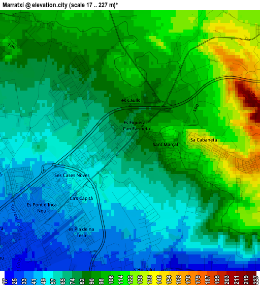
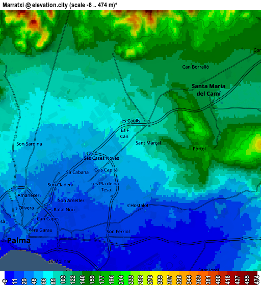
Below is the Elevation map of Marratxí, which displays elevation range with different colors. Scale of the first map is from 17 to 227 m (56 to 745 ft) with average elevation of 81.5 meters (=267 ft) [note 1]
These maps also provides idea of topography and contour of this city, they are displayed at different zoom levels. More info about maps, scale and edge coordinates you can find below images.
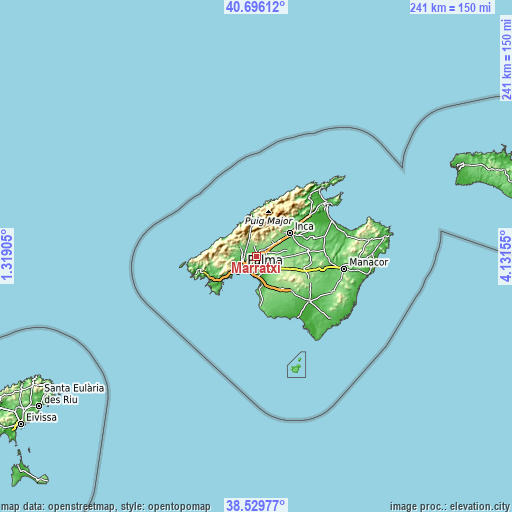
| \ | Map #1 | Map #2 | Topo.Map |
| Scale [m] | 17..227 m | -8..474 m | × |
| Scale [ft] | 56..745 ft | -26..1555 ft | × |
| Average | 81.5 m = 267 ft | 92.7 m = 304 ft | × |
| Width | 7.53 km = 4.7 mi | 15.06 km = 9.4 mi | 240.9 km = 149.7 mi |
| Height | 7.53 km = 4.7 mi | 15.06 km = 9.4 mi | 240.9 km = 149.7 mi |
| ↑Max Latitude | 39.655262° | 39.689087° | 40.69612° |
| Latitude at center | 39.62142° | 39.62142° | 39.62142° |
| ↓Min Latitude | 39.587562° | 39.553687° | 38.52977° |
| ← Min Longitude | 2.681355° | 2.637409° | 1.31905° |
| Longitude center | 2.7253° | 2.7253° | 2.7253° |
| →Max Longitude | 2.769245° | 2.813191° | 4.13155° |
Nearby cities:
Cities around Marratxí sort by population:
• Palma elevation 34 m
8.7 km,  228°
228°
• Coll d'en Rabassa 12 m
8.3 km,  198°
198°
• Es Molinar 4 m
7.9 km,  212°
212°
• Binissalem 133 m
12.5 km,  54°
54°
• Bunyola 217 m
8.6 km,  345°
345°
• Can Pastilla 8 m
9.5 km,  183°
183°
• Alaró 217 m
10.8 km,  31°
31°
• Esporles 188 m
13.6 km,  292°
292°
• Consell 152 m
9.1 km, 54°
• Valldemossa 412 m
13.3 km,  318°
318°
• Santa Eugènia 138 m
9.7 km,  88°
88°
• Santa Maria del Camí 131 m
5.3 km, 51°
Multilingual:
 En español:
Marratxí elevación 72 m.
 En France:
Marratxí élévation 72 m.


Sources and notes:
- [note 1] Map square and city borders are not equal. Map elevation data is calculated only from area inside that square.
- [src 1] Elevation data from geonames database provided with same terms of usage.
- [src 2] The elevation map of Marratxí is generated using elevation data from NASA's 3 arcsec (90m) resolution SRTM data.
- [src 3] Base (background) map © OpenStreetMap contributors tiles are generated by Geofabrik and OpenTopoMap.
Copyright & License:
This Marratxí Elevation Map is licensed under CC BY-SA. You may reuse any part from this page, if you give a proper credit by linking to this URL:
 More info on terms of use page.