Fuentes de Andalucía elevation
Fuentes de Andalucía (Andalusia, Provincia de Sevilla), Spain elevation is 181 meters and Fuentes de Andalucía elevation in feet is 594 ft above sea level [src 1]. Fuentes de Andalucía is a seat of a third-order administrative division (feature code) with elevation that is 422 meters (1385 ft) smaller than average city elevation in Spain.
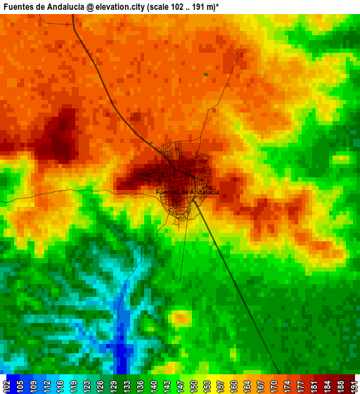
Below is the Elevation map of Fuentes de Andalucía, which displays elevation range with different colors. Scale of the first map is from 102 to 191 m (335 to 627 ft) with average elevation of 152.5 meters (=500 ft) [note 1]
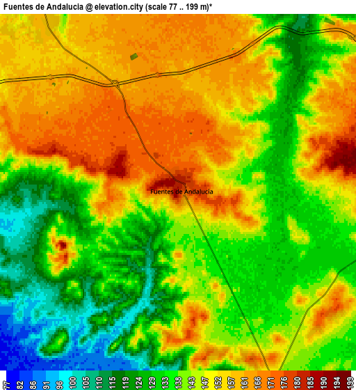
These maps also provides idea of topography and contour of this city, they are displayed at different zoom levels. More info about maps, scale and edge coordinates you can find below images.
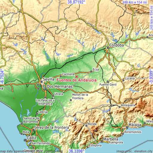
| \ | Map #1 | Map #2 | Topo.Map |
| Scale [m] | 102..191 m | 77..199 m | × |
| Scale [ft] | 335..627 ft | 253..653 ft | × |
| Average | 152.5 m = 500 ft | 144 m = 472 ft | × |
| Width | 7.76 km = 4.8 mi | 15.51 km = 9.6 mi | 248.2 km = 154.2 mi |
| Height | 7.76 km = 4.8 mi | 15.51 km = 9.6 mi | 248.2 km = 154.2 mi |
| ↑Max Latitude | 37.498963° | 37.533819° | 38.57192° |
| Latitude at center | 37.46409° | 37.46409° | 37.46409° |
| ↓Min Latitude | 37.429201° | 37.394296° | 36.3396° |
| ← Min Longitude | -5.390095° | -5.434041° | -6.7524° |
| Longitude center | -5.34615° | -5.34615° | -5.34615° |
| →Max Longitude | -5.302205° | -5.258259° | -3.9399° |
Nearby cities:
Cities around Fuentes de Andalucía sort by population:
• Écija elevation 105 m
24.8 km,  69°
69°
• Carmona 221 m
26.5 km,  271°
271°
• Palma del Río 60 m
26.9 km,  12°
12°
• Marchena 131 m
16.3 km,  202°
202°
• Lora del Río 41 m
26.9 km,  323°
323°
• La Puebla de Cazalla 177 m
27.1 km,  173°
173°
• Paradas 120 m
23.5 km,  214°
214°
• La Campana 140 m
13.6 km,  328°
328°
• La Luisiana 171 m
11 km,  51°
51°
• La Lantejuela 156 m
16.3 km,  138°
138°
• Peñaflor 68 m
27.2 km,  0°
0°
• Cañada Rosal 157 m
19.2 km,  38°
38°
Multilingual:
 En español:
Fuentes de Andalucía elevación 181 m.
 En France:
Fuentes de Andalucía élévation 181 m.
 Auf Deutsch:
Fuentes de Andalucía höhe über dem Meeresspiegel ist 181 m.
 На русском:
Fuentes de Andalucía высота над уровнем моря 181 м
Sources and notes:
- [note 1] Map square and city borders are not equal. Map elevation data is calculated only from area inside that square.
- [src 1] Elevation data from geonames database provided with same terms of usage.
- [src 2] The elevation map of Fuentes de Andalucía is generated using elevation data from NASA's 3 arcsec (90m) resolution SRTM data.
- [src 3] Base (background) map © OpenStreetMap contributors tiles are generated by Geofabrik and OpenTopoMap.
Copyright & License:
This Fuentes de Andalucía Elevation Map is licensed under CC BY-SA. You may reuse any part from this page, if you give a proper credit by linking to this URL:
 More info on terms of use page.