Galera elevation
Galera (Andalusia, Provincia de Granada), Spain elevation is 839 meters and Galera elevation in feet is 2753 ft above sea level [src 1]. Galera is a seat of a third-order administrative division (feature code) with elevation that is 236 meters (774 ft) bigger than average city elevation in Spain.
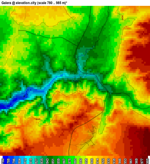
Below is the Elevation map of Galera, which displays elevation range with different colors. Scale of the first map is from 780 to 985 m (2559 to 3232 ft) with average elevation of 896.7 meters (=2942 ft) [note 1]
These maps also provides idea of topography and contour of this city, they are displayed at different zoom levels. More info about maps, scale and edge coordinates you can find below images.
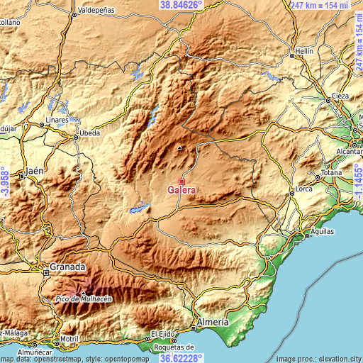
| \ | Map #1 | Topo.Map |
| Scale [m] | 780..985 m | × |
| Scale [ft] | 2559..3232 ft | × |
| Average | 896.7 m = 2942 ft | × |
| Width | 7.73 km = 4.8 mi | 247.3 km = 153.7 mi |
| Height | 7.73 km = 4.8 mi | 247.3 km = 153.7 mi |
| ↑Max Latitude | 37.777362° | 38.84626° |
| Latitude at center | 37.74262° | 37.74262° |
| ↓Min Latitude | 37.707861° | 36.62228° |
| ← Min Longitude | -2.595695° | -3.958° |
| Longitude center | -2.55175° | -2.55175° |
| →Max Longitude | -2.507805° | -1.1455° |
Nearby cities:
Cities around Galera sort by population:
• Baza elevation 842 m
34.1 km,  214°
214°
• Huéscar 958 m
7.7 km,  6°
6°
• Pozo Alcón 861 m
33.9 km,  262°
262°
• Zújar 780 m
33.9 km,  228°
228°
• Castril 896 m
20.9 km,  286°
286°
• Cortes de Baza 701 m
21.7 km,  243°
243°
• Benamaurel 697 m
20 km,  221°
221°
• Chirivel 1046 m
29.8 km,  123°
123°
• Castilléjar 769 m
8.3 km,  249°
249°
• María 1200 m
34.2 km,  96°
96°
• Orce 941 m
6.9 km,  110°
110°
• Puebla de Don Fadrique 1196 m
26.3 km,  22°
22°
Multilingual:
 En español:
Galera elevación 839 m.
 En France:
Galera élévation 839 m.


Sources and notes:
- [note 1] Map square and city borders are not equal. Map elevation data is calculated only from area inside that square.
- [src 1] Elevation data from geonames database provided with same terms of usage.
- [src 2] The elevation map of Galera is generated using elevation data from NASA's 3 arcsec (90m) resolution SRTM data.
- [src 3] Base (background) map © OpenStreetMap contributors tiles are generated by Geofabrik and OpenTopoMap.
Copyright & License:
This Galera Elevation Map is licensed under CC BY-SA. You may reuse any part from this page, if you give a proper credit by linking to this URL:
 More info on terms of use page.