Herrera de Alcántara elevation
Herrera de Alcántara (Extremadura, Provincia de Cáceres), Spain elevation is 258 meters and Herrera de Alcántara elevation in feet is 846 ft above sea level [src 1]. Herrera de Alcántara is a seat of a third-order administrative division (feature code) with elevation that is 345 meters (1132 ft) smaller than average city elevation in Spain.
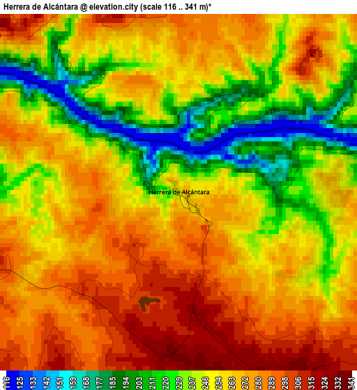
Below is the Elevation map of Herrera de Alcántara, which displays elevation range with different colors. Scale of the first map is from 116 to 341 m (381 to 1119 ft) with average elevation of 256.2 meters (=841 ft) [note 1]
These maps also provides idea of topography and contour of this city, they are displayed at different zoom levels. More info about maps, scale and edge coordinates you can find below images.
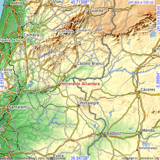
| \ | Map #1 | Topo.Map |
| Scale [m] | 116..341 m | × |
| Scale [ft] | 381..1119 ft | × |
| Average | 256.2 m = 841 ft | × |
| Width | 7.53 km = 4.7 mi | 240.8 km = 149.6 mi |
| Height | 7.53 km = 4.7 mi | 240.8 km = 149.6 mi |
| ↑Max Latitude | 39.672483° | 40.71308° |
| Latitude at center | 39.63865° | 39.63865° |
| ↓Min Latitude | 39.6048° | 38.54726° |
| ← Min Longitude | -7.450135° | -8.81244° |
| Longitude center | -7.40619° | -7.40619° |
| →Max Longitude | -7.362245° | -5.99994° |
Nearby cities:
Cities around Herrera de Alcántara sort by population:
• Valencia de Alcántara elevation 465 m
28.8 km,  151°
151°
• La Codosera 323 m
51.8 km,  157°
157°
• Alcántara 240 m
45.6 km,  78°
78°
• Zarza la Mayor 305 m
53.5 km,  60°
60°
• Salorino 323 m
38.4 km,  117°
117°
• Cedillo 269 m
8 km,  279°
279°
• Mata de Alcántara 336 m
51.1 km, 80°
• Carbajo 339 m
18.5 km,  102°
102°
• Piedras Albas 352 m
44.2 km,  68°
68°
• Villa del Rey 340 m
50.1 km,  87°
87°
• San Vicente de Alcántara 504 m
38.5 km,  143°
143°
• Santiago de Alcántara 347 m
14.3 km, 104°
Multilingual:
 En español:
Herrera de Alcántara elevación 258 m.
 En France:
Herrera de Alcántara élévation 258 m.
 Auf Deutsch:
Herrera de Alcántara höhe über dem Meeresspiegel ist 258 m.
 На русском:
Herrera de Alcántara высота над уровнем моря 258 м
Sources and notes:
- [note 1] Map square and city borders are not equal. Map elevation data is calculated only from area inside that square.
- [src 1] Elevation data from geonames database provided with same terms of usage.
- [src 2] The elevation map of Herrera de Alcántara is generated using elevation data from NASA's 3 arcsec (90m) resolution SRTM data.
- [src 3] Base (background) map © OpenStreetMap contributors tiles are generated by Geofabrik and OpenTopoMap.
Copyright & License:
This Herrera de Alcántara Elevation Map is licensed under CC BY-SA. You may reuse any part from this page, if you give a proper credit by linking to this URL:
 More info on terms of use page.