La Cumbre elevation
La Cumbre (Extremadura, Provincia de Cáceres), Spain elevation is 482 meters and La Cumbre elevation in feet is 1581 ft above sea level [src 1]. La Cumbre is a populated place (feature code) with elevation that is 121 meters (397 ft) smaller than average city elevation in Spain.
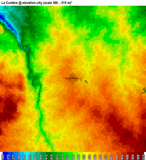
Below is the Elevation map of La Cumbre, which displays elevation range with different colors. Scale of the first map is from 366 to 515 m (1201 to 1690 ft) with average elevation of 459.3 meters (=1507 ft) [note 1]
These maps also provides idea of topography and contour of this city, they are displayed at different zoom levels. More info about maps, scale and edge coordinates you can find below images.
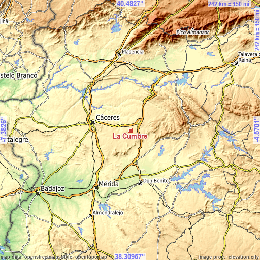
| \ | Map #1 | Topo.Map |
| Scale [m] | 366..515 m | × |
| Scale [ft] | 1201..1690 ft | × |
| Average | 459.3 m = 1507 ft | × |
| Width | 7.55 km = 4.7 mi | 241.6 km = 150.1 mi |
| Height | 7.55 km = 4.7 mi | 241.6 km = 150.1 mi |
| ↑Max Latitude | 39.438548° | 40.4827° |
| Latitude at center | 39.4046° | 39.4046° |
| ↓Min Latitude | 39.370636° | 38.30957° |
| ← Min Longitude | -6.020295° | -7.3826° |
| Longitude center | -5.97635° | -5.97635° |
| →Max Longitude | -5.932405° | -4.5701° |
Nearby cities:
Cities around La Cumbre sort by population:
• Trujillo elevation 520 m
10 km,  53°
53°
• Ibahernando 532 m
10.1 km,  150°
150°
• Plasenzuela 427 m
6.6 km,  247°
247°
• Robledillo de Trujillo 500 m
15 km,  181°
181°
• Puerto de Santa Cruz 458 m
14.1 km,  134°
134°
• Salvatierra de Santiago 439 m
12.2 km,  203°
203°
• Santa Ana 489 m
10.8 km,  186°
186°
• Santa Cruz de la Sierra 455 m
13.6 km,  124°
124°
• Santa Marta de Magasca 377 m
15.9 km,  318°
318°
• Botija 423 m
10.6 km,  231°
231°
• Benquerencia 448 m
14.1 km,  221°
221°
• Ruanes 480 m
9.1 km, 200°
Multilingual:
 En español:
La Cumbre elevación 482 m.
 En France:
La Cumbre élévation 482 m.
 Auf Deutsch:
La Cumbre höhe über dem Meeresspiegel ist 482 m.

Sources and notes:
- [note 1] Map square and city borders are not equal. Map elevation data is calculated only from area inside that square.
- [src 1] Elevation data from geonames database provided with same terms of usage.
- [src 2] The elevation map of La Cumbre is generated using elevation data from NASA's 3 arcsec (90m) resolution SRTM data.
- [src 3] Base (background) map © OpenStreetMap contributors tiles are generated by Geofabrik and OpenTopoMap.
Copyright & License:
This La Cumbre Elevation Map is licensed under CC BY-SA. You may reuse any part from this page, if you give a proper credit by linking to this URL:
 More info on terms of use page.