Los Villares elevation
Los Villares (Andalusia, Provincia de Jaén), Spain elevation is 617 meters and Los Villares elevation in feet is 2024 ft above sea level [src 1]. Los Villares is a populated place (feature code) with elevation that is 14 meters (46 ft) bigger than average city elevation in Spain.
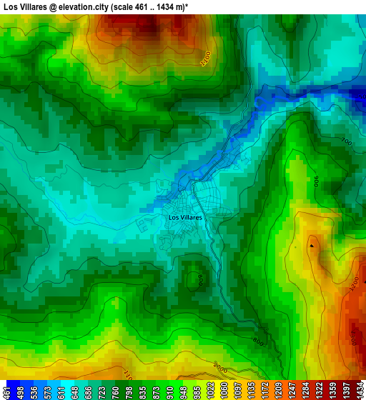
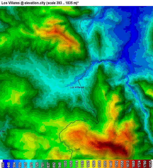
Below is the Elevation map of Los Villares, which displays elevation range with different colors. Scale of the first map is from 461 to 1434 m (1512 to 4705 ft) with average elevation of 831.3 meters (=2727 ft) [note 1]
These maps also provides idea of topography and contour of this city, they are displayed at different zoom levels. More info about maps, scale and edge coordinates you can find below images.
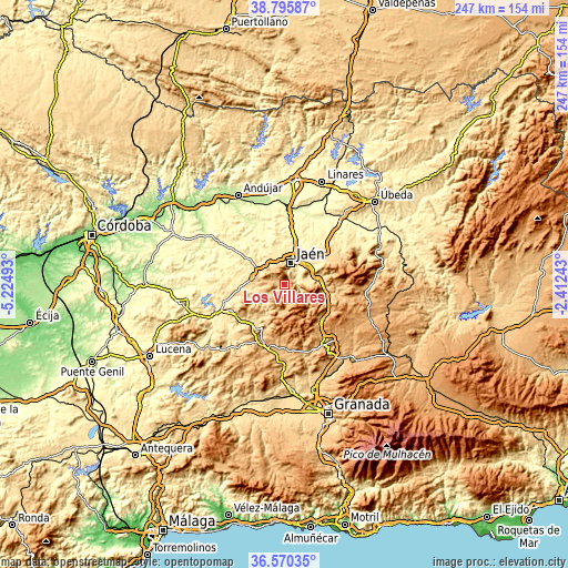
| \ | Map #1 | Map #2 | Topo.Map |
| Scale [m] | 461..1434 m | 393..1835 m | × |
| Scale [ft] | 1512..4705 ft | 1289..6020 ft | × |
| Average | 831.3 m = 2727 ft | 906 m = 2972 ft | × |
| Width | 7.73 km = 4.8 mi | 15.47 km = 9.6 mi | 247.5 km = 153.8 mi |
| Height | 7.73 km = 4.8 mi | 15.47 km = 9.6 mi | 247.5 km = 153.8 mi |
| ↑Max Latitude | 37.726226° | 37.760977° | 38.79587° |
| Latitude at center | 37.69146° | 37.69146° | 37.69146° |
| ↓Min Latitude | 37.656677° | 37.621878° | 36.57035° |
| ← Min Longitude | -3.862625° | -3.906571° | -5.22493° |
| Longitude center | -3.81868° | -3.81868° | -3.81868° |
| →Max Longitude | -3.774735° | -3.730789° | -2.41243° |
Nearby cities:
Cities around Los Villares sort by population:
• Jaén elevation 558 m
9 km,  16°
16°
• Martos 661 m
13.9 km,  283°
283°
• Torre del Campo 645 m
11.2 km,  321°
321°
• Torredonjimeno 596 m
14.9 km,  304°
304°
• Mancha Real 756 m
21 km,  59°
59°
• Castillo de Locubín 727 m
21.1 km,  210°
210°
• Valdepeñas de Jaén 963 m
11.4 km,  178°
178°
• Jamilena 746 m
10.4 km,  306°
306°
• Fuensanta de Martos 755 m
9.3 km,  238°
238°
• Pegalajar 821 m
15.8 km,  70°
70°
• La Guardia de Jaén 596 m
12.4 km, 62°
• Fuerte del Rey 428 m
21.2 km,  344°
344°
Multilingual:
 En español:
Los Villares elevación 617 m.
 En France:
Los Villares élévation 617 m.
 Auf Deutsch:
Los Villares höhe über dem Meeresspiegel ist 617 m.

Sources and notes:
- [note 1] Map square and city borders are not equal. Map elevation data is calculated only from area inside that square.
- [src 1] Elevation data from geonames database provided with same terms of usage.
- [src 2] The elevation map of Los Villares is generated using elevation data from NASA's 3 arcsec (90m) resolution SRTM data.
- [src 3] Base (background) map © OpenStreetMap contributors tiles are generated by Geofabrik and OpenTopoMap.
Copyright & License:
This Los Villares Elevation Map is licensed under CC BY-SA. You may reuse any part from this page, if you give a proper credit by linking to this URL:
 More info on terms of use page.