Málaga elevation
Málaga (Andalusia, Provincia de Málaga), Spain elevation is 22 meters and Málaga elevation in feet is 72 ft above sea level [src 1]. Málaga is a seat of a second-order administrative division (feature code) with elevation that is 581 meters (1906 ft) smaller than average city elevation in Spain.
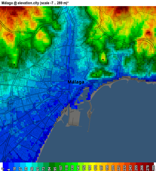
Below is the Elevation map of Málaga, which displays elevation range with different colors. Scale of the first map is from -7 to 289 m (-23 to 948 ft) with average elevation of 76.3 meters (=250 ft) [note 1]
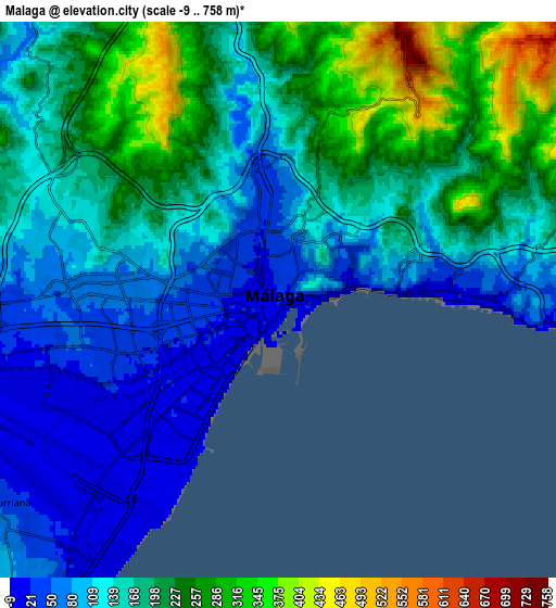
These maps also provides idea of topography and contour of this city, they are displayed at different zoom levels. More info about maps, scale and edge coordinates you can find below images.
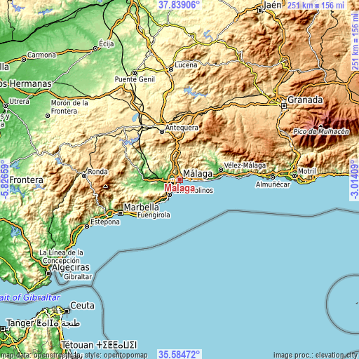
| \ | Map #1 | Map #2 | Topo.Map |
| Scale [m] | -7..289 m | -9..758 m | × |
| Scale [ft] | -23..948 ft | -30..2487 ft | × |
| Average | 76.3 m = 250 ft | 162.1 m = 532 ft | × |
| Width | 7.83 km = 4.9 mi | 15.67 km = 9.7 mi | 250.7 km = 155.8 mi |
| Height | 7.83 km = 4.9 mi | 15.67 km = 9.7 mi | 250.7 km = 155.8 mi |
| ↑Max Latitude | 36.755377° | 36.790578° | 37.83906° |
| Latitude at center | 36.72016° | 36.72016° | 36.72016° |
| ↓Min Latitude | 36.684927° | 36.649678° | 35.58472° |
| ← Min Longitude | -4.464285° | -4.508231° | -5.82659° |
| Longitude center | -4.42034° | -4.42034° | -4.42034° |
| →Max Longitude | -4.376395° | -4.332449° | -3.01409° |
Nearby cities:
Cities around Málaga sort by population:
• Torremolinos elevation 47 m
13.2 km,  212°
212°
• Benalmádena 240 m
19.4 km,  224°
224°
• Rincón de la Victoria 11 m
12.9 km,  91°
91°
• Alhaurín de la Torre 93 m
14 km,  243°
243°
• Cártama 89 m
19 km,  266°
266°
• Valdés 293 m
16.4 km,  75°
75°
• Estación de Cártama 40 m
17.6 km, 274°
• Almogía 381 m
15.9 km,  317°
317°
• Casabermeja 568 m
19.2 km,  357°
357°
• Almáchar 222 m
20.7 km,  61°
61°
• Moclinejo 463 m
15.8 km,  68°
68°
• Totalán 277 m
12.1 km, 65°
Multilingual:
 En español:
Málaga elevación 22 m.
 En France:
Málaga élévation 22 m.


Sources and notes:
- [note 1] Map square and city borders are not equal. Map elevation data is calculated only from area inside that square.
- [src 1] Elevation data from geonames database provided with same terms of usage.
- [src 2] The elevation map of Málaga is generated using elevation data from NASA's 3 arcsec (90m) resolution SRTM data.
- [src 3] Base (background) map © OpenStreetMap contributors tiles are generated by Geofabrik and OpenTopoMap.
Copyright & License:
This Málaga Elevation Map is licensed under CC BY-SA. You may reuse any part from this page, if you give a proper credit by linking to this URL:
 More info on terms of use page.