Mogente elevation
Mogente (Valencia, Província de València), Spain elevation is 333 meters and Mogente elevation in feet is 1093 ft above sea level [src 1]. Mogente is a populated place (feature code) with elevation that is 270 meters (886 ft) smaller than average city elevation in Spain.
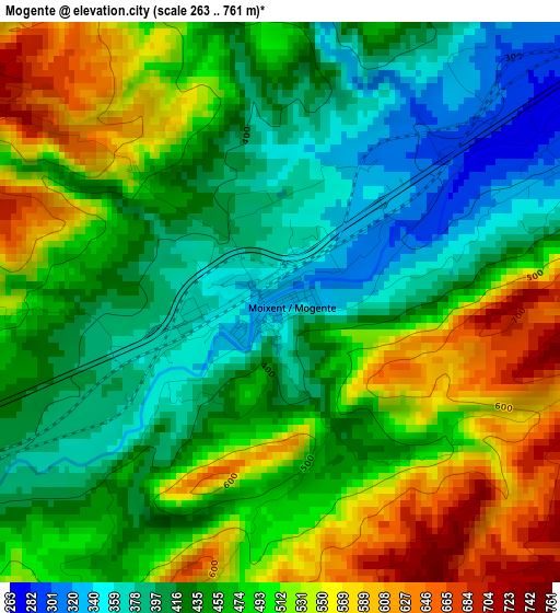
Below is the Elevation map of Mogente, which displays elevation range with different colors. Scale of the first map is from 263 to 761 m (863 to 2497 ft) with average elevation of 468.2 meters (=1536 ft) [note 1]
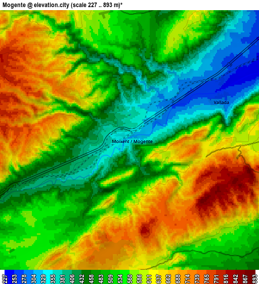
These maps also provides idea of topography and contour of this city, they are displayed at different zoom levels. More info about maps, scale and edge coordinates you can find below images.
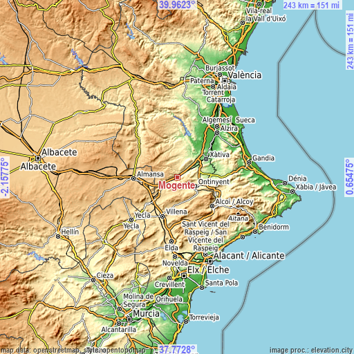
| \ | Map #1 | Map #2 | Topo.Map |
| Scale [m] | 263..761 m | 227..893 m | × |
| Scale [ft] | 863..2497 ft | 745..2930 ft | × |
| Average | 468.2 m = 1536 ft | 547.6 m = 1797 ft | × |
| Width | 7.61 km = 4.7 mi | 15.22 km = 9.5 mi | 243.4 km = 151.2 mi |
| Height | 7.61 km = 4.7 mi | 15.22 km = 9.5 mi | 243.4 km = 151.2 mi |
| ↑Max Latitude | 38.910183° | 38.94437° | 39.9623° |
| Latitude at center | 38.87598° | 38.87598° | 38.87598° |
| ↓Min Latitude | 38.84176° | 38.807524° | 37.7728° |
| ← Min Longitude | -0.795445° | -0.839391° | -2.15775° |
| Longitude center | -0.7515° | -0.7515° | -0.7515° |
| →Max Longitude | -0.707555° | -0.663609° | 0.65475° |
Nearby cities:
Cities around Mogente sort by population:
• Ontinyent elevation 369 m
14 km,  115°
115°
• Canals 166 m
17.4 km,  56°
56°
• L'Olleria 255 m
18 km,  75°
75°
• Enguera 315 m
12.8 km,  25°
25°
• L'Alcúdia de Crespìns 158 m
17.7 km, 55°
• Bocairent 668 m
16.9 km,  136°
136°
• Aielo de Malferit 269 m
14.6 km,  86°
86°
• Vallada 291 m
5.7 km,  67°
67°
• Anna 208 m
18.4 km, 29°
• La Font de la Figuera 588 m
14.2 km,  233°
233°
• Montesa 297 m
11.9 km,  46°
46°
• Fontanars dels Alforins 629 m
10.6 km,  196°
196°
Multilingual:
 En español:
Mogente elevación 333 m.
 En France:
Mogente élévation 333 m.


Sources and notes:
- [note 1] Map square and city borders are not equal. Map elevation data is calculated only from area inside that square.
- [src 1] Elevation data from geonames database provided with same terms of usage.
- [src 2] The elevation map of Mogente is generated using elevation data from NASA's 3 arcsec (90m) resolution SRTM data.
- [src 3] Base (background) map © OpenStreetMap contributors tiles are generated by Geofabrik and OpenTopoMap.
Copyright & License:
This Mogente Elevation Map is licensed under CC BY-SA. You may reuse any part from this page, if you give a proper credit by linking to this URL:
 More info on terms of use page.