Navalmoral de la Mata elevation
Navalmoral de la Mata (Extremadura, Provincia de Cáceres), Spain elevation is 295 meters and Navalmoral de la Mata elevation in feet is 968 ft above sea level [src 1]. Navalmoral de la Mata is a seat of a third-order administrative division (feature code) with elevation that is 308 meters (1010 ft) smaller than average city elevation in Spain.
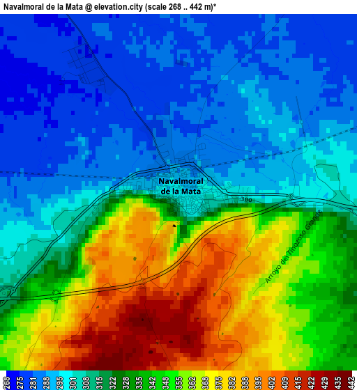
Below is the Elevation map of Navalmoral de la Mata, which displays elevation range with different colors. Scale of the first map is from 268 to 442 m (879 to 1450 ft) with average elevation of 324.3 meters (=1064 ft) [note 1]
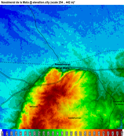
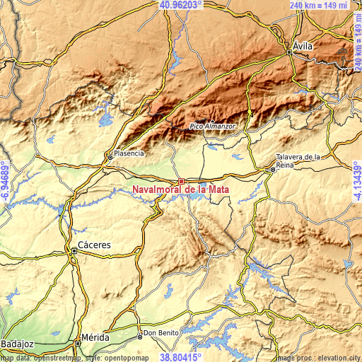
These maps also provides idea of topography and contour of this city, they are displayed at different zoom levels. More info about maps, scale and edge coordinates you can find below images.
| \ | Map #1 | Map #2 | Topo.Map |
| Scale [m] | 268..442 m | 254..442 m | × |
| Scale [ft] | 879..1450 ft | 833..1450 ft | × |
| Average | 324.3 m = 1064 ft | 309.9 m = 1017 ft | × |
| Width | 7.5 km = 4.7 mi | 15 km = 9.3 mi | 239.9 km = 149.1 mi |
| Height | 7.5 km = 4.7 mi | 15 km = 9.3 mi | 239.9 km = 149.1 mi |
| ↑Max Latitude | 39.925289° | 39.958982° | 40.96203° |
| Latitude at center | 39.89158° | 39.89158° | 39.89158° |
| ↓Min Latitude | 39.857854° | 39.824112° | 38.80415° |
| ← Min Longitude | -5.584585° | -5.628531° | -6.94689° |
| Longitude center | -5.54064° | -5.54064° | -5.54064° |
| →Max Longitude | -5.496695° | -5.452749° | -4.13439° |
Nearby cities:
Cities around Navalmoral de la Mata sort by population:
• Talayuela elevation 290 m
12.1 km,  330°
330°
• Peraleda de la Mata 343 m
8.1 km,  122°
122°
• Casatejada 273 m
12.1 km,  267°
267°
• Almaraz 273 m
14.5 km,  233°
233°
• Saucedilla 261 m
12.5 km,  249°
249°
• Bohonal de Ibor 355 m
12.8 km,  158°
158°
• Valdehúncar 372 m
6.3 km,  166°
166°
• Mesas de Ibor 486 m
15.1 km,  181°
181°
• Valdecañas de Tajo 371 m
16.2 km,  204°
204°
• Millanes 371 m
5.8 km,  216°
216°
• Berrocalejo 376 m
18.2 km, 116°
• Tiétar 275 m
16.1 km,  18°
18°
Multilingual:
 En español:
Navalmoral de la Mata elevación 295 m.
 En France:
Navalmoral de la Mata élévation 295 m.
 Auf Deutsch:
Navalmoral de la Mata höhe über dem Meeresspiegel ist 295 m.
 На русском:
Навальмораль-де-ла-Мата высота над уровнем моря 295 м
Sources and notes:
- [note 1] Map square and city borders are not equal. Map elevation data is calculated only from area inside that square.
- [src 1] Elevation data from geonames database provided with same terms of usage.
- [src 2] The elevation map of Navalmoral de la Mata is generated using elevation data from NASA's 3 arcsec (90m) resolution SRTM data.
- [src 3] Base (background) map © OpenStreetMap contributors tiles are generated by Geofabrik and OpenTopoMap.
Copyright & License:
This Navalmoral de la Mata Elevation Map is licensed under CC BY-SA. You may reuse any part from this page, if you give a proper credit by linking to this URL:
 More info on terms of use page.