Navalpino elevation
Navalpino (Castille-La Mancha, Provincia de Ciudad Real), Spain elevation is 625 meters and Navalpino elevation in feet is 2051 ft above sea level [src 1]. Navalpino is a seat of a third-order administrative division (feature code) with elevation that is 22 meters (72 ft) bigger than average city elevation in Spain.
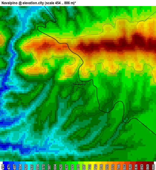
Below is the Elevation map of Navalpino, which displays elevation range with different colors. Scale of the first map is from 454 to 886 m (1490 to 2907 ft) with average elevation of 633.2 meters (=2077 ft) [note 1]
These maps also provides idea of topography and contour of this city, they are displayed at different zoom levels. More info about maps, scale and edge coordinates you can find below images.
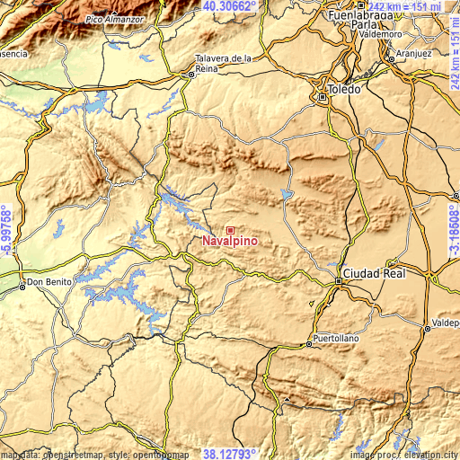
| \ | Map #1 | Topo.Map |
| Scale [m] | 454..886 m | × |
| Scale [ft] | 1490..2907 ft | × |
| Average | 633.2 m = 2077 ft | × |
| Width | 7.57 km = 4.7 mi | 242.2 km = 150.5 mi |
| Height | 7.57 km = 4.7 mi | 242.2 km = 150.5 mi |
| ↑Max Latitude | 39.259764° | 40.30662° |
| Latitude at center | 39.22573° | 39.22573° |
| ↓Min Latitude | 39.191679° | 38.12793° |
| ← Min Longitude | -4.635275° | -5.99758° |
| Longitude center | -4.59133° | -4.59133° |
| →Max Longitude | -4.547385° | -3.18508° |
Nearby cities:
Cities around Navalpino sort by population:
• Fuenlabrada de los Montes elevation 539 m
31.4 km,  250°
250°
• Rosalejo 495 m
36 km,  310°
310°
• Puebla de Don Rodrigo 501 m
15.8 km,  188°
188°
• El Robledo 589 m
26.7 km,  91°
91°
• Retuerta de Bullaque 744 m
30.5 km,  30°
30°
• Alcoba 634 m
10.5 km,  68°
68°
• Saceruela 591 m
31.4 km,  182°
182°
• Navas de Estena 665 m
30.5 km,  11°
11°
• Fontanarejo 637 m
6.4 km,  95°
95°
• Agudo 566 m
36.3 km,  221°
221°
• Anchuras 548 m
35.2 km,  323°
323°
• Villarta de los Montes 550 m
17.4 km,  265°
265°
Multilingual:
 En español:
Navalpino elevación 625 m.
 En France:
Navalpino élévation 625 m.
 Auf Deutsch:
Navalpino höhe über dem Meeresspiegel ist 625 m.

Sources and notes:
- [note 1] Map square and city borders are not equal. Map elevation data is calculated only from area inside that square.
- [src 1] Elevation data from geonames database provided with same terms of usage.
- [src 2] The elevation map of Navalpino is generated using elevation data from NASA's 3 arcsec (90m) resolution SRTM data.
- [src 3] Base (background) map © OpenStreetMap contributors tiles are generated by Geofabrik and OpenTopoMap.
Copyright & License:
This Navalpino Elevation Map is licensed under CC BY-SA. You may reuse any part from this page, if you give a proper credit by linking to this URL:
 More info on terms of use page.