Orihuela elevation
Orihuela (Valencia, Provincia de Alicante), Spain elevation is 32 meters and Orihuela elevation in feet is 105 ft above sea level [src 1]. Orihuela is a seat of a third-order administrative division (feature code) with elevation that is 571 meters (1873 ft) smaller than average city elevation in Spain.
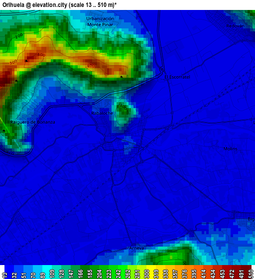
Below is the Elevation map of Orihuela, which displays elevation range with different colors. Scale of the first map is from 13 to 510 m (43 to 1673 ft) with average elevation of 64.5 meters (=212 ft) [note 1]
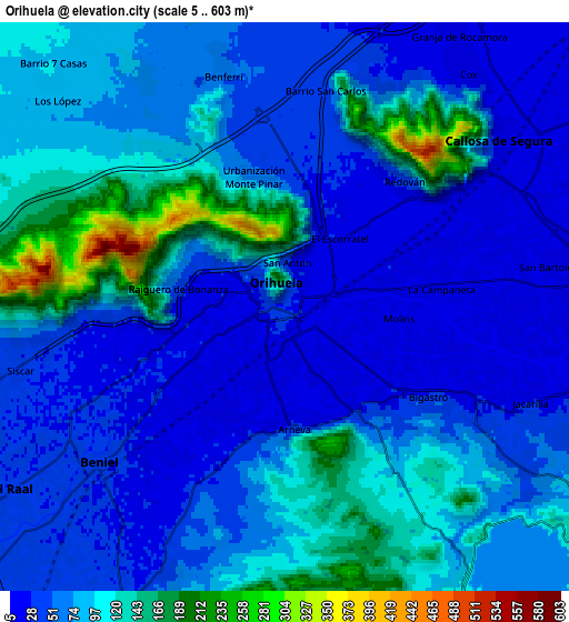
These maps also provides idea of topography and contour of this city, they are displayed at different zoom levels. More info about maps, scale and edge coordinates you can find below images.
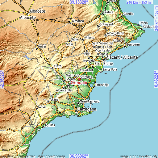
| \ | Map #1 | Map #2 | Topo.Map |
| Scale [m] | 13..510 m | 5..603 m | × |
| Scale [ft] | 43..1673 ft | 16..1978 ft | × |
| Average | 64.5 m = 212 ft | 74.7 m = 245 ft | × |
| Width | 7.69 km = 4.8 mi | 15.38 km = 9.6 mi | 246.1 km = 152.9 mi |
| Height | 7.69 km = 4.8 mi | 15.38 km = 9.6 mi | 246.1 km = 152.9 mi |
| ↑Max Latitude | 38.119411° | 38.153976° | 39.18328° |
| Latitude at center | 38.08483° | 38.08483° | 38.08483° |
| ↓Min Latitude | 38.050233° | 38.015619° | 36.96962° |
| ← Min Longitude | -0.987955° | -1.031901° | -2.35026° |
| Longitude center | -0.94401° | -0.94401° | -0.94401° |
| →Max Longitude | -0.900065° | -0.856119° | 0.46224° |
Nearby cities:
Cities around Orihuela sort by population:
• Callosa de Segura elevation 23 m
7.3 km,  52°
52°
• Santomera 38 m
9.5 km,  254°
254°
• Beniel 32 m
6.7 km,  230°
230°
• Redován 26 m
4.6 km,  40°
40°
• Cox 22 m
8 km, 38°
• Bigastro 32 m
4.7 km,  122°
122°
• Benejúzar 28 m
9.2 km,  95°
95°
• Rafal 16 m
8.6 km,  75°
75°
• Granja de Rocamora 20 m
8.7 km,  31°
31°
• Cobatillas 56 m
12.1 km, 254°
• Jacarilla 25 m
7.1 km,  110°
110°
• Benferri 55 m
6.5 km,  345°
345°
Multilingual:
 En español:
Orihuela elevación 32 m.
 En France:
Orihuela élévation 32 m.


Sources and notes:
- [note 1] Map square and city borders are not equal. Map elevation data is calculated only from area inside that square.
- [src 1] Elevation data from geonames database provided with same terms of usage.
- [src 2] The elevation map of Orihuela is generated using elevation data from NASA's 3 arcsec (90m) resolution SRTM data.
- [src 3] Base (background) map © OpenStreetMap contributors tiles are generated by Geofabrik and OpenTopoMap.
Copyright & License:
This Orihuela Elevation Map is licensed under CC BY-SA. You may reuse any part from this page, if you give a proper credit by linking to this URL:
 More info on terms of use page.