Santomera elevation
Santomera (Murcia), Spain elevation is 38 meters and Santomera elevation in feet is 125 ft above sea level [src 1]. Santomera is a seat of a third-order administrative division (feature code) with elevation that is 565 meters (1854 ft) smaller than average city elevation in Spain.
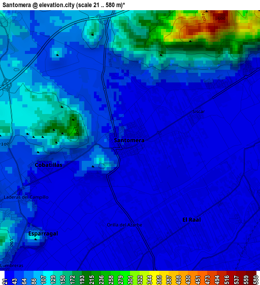
Below is the Elevation map of Santomera, which displays elevation range with different colors. Scale of the first map is from 21 to 580 m (69 to 1903 ft) with average elevation of 71.5 meters (=235 ft) [note 1]
These maps also provides idea of topography and contour of this city, they are displayed at different zoom levels. More info about maps, scale and edge coordinates you can find below images.
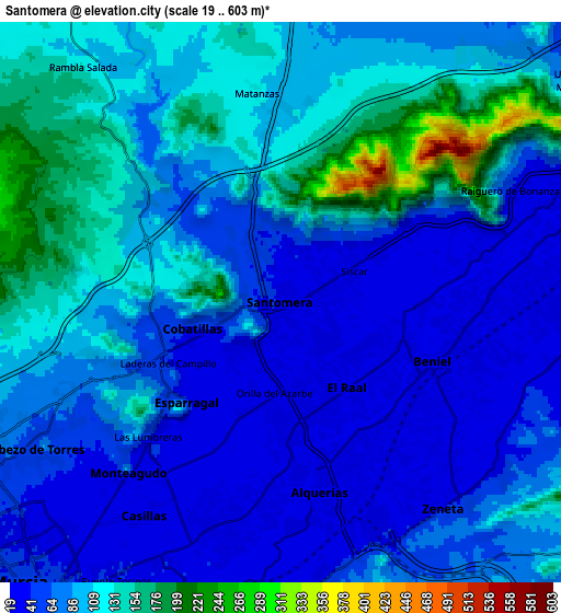
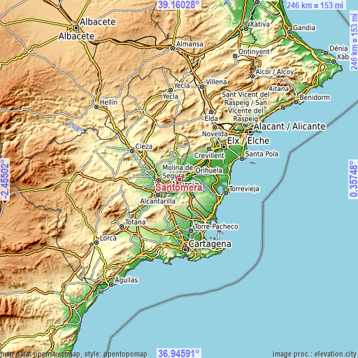
| \ | Map #1 | Map #2 | Topo.Map |
| Scale [m] | 21..580 m | 19..603 m | × |
| Scale [ft] | 69..1903 ft | 62..1978 ft | × |
| Average | 71.5 m = 235 ft | 87.9 m = 288 ft | × |
| Width | 7.69 km = 4.8 mi | 15.39 km = 9.6 mi | 246.2 km = 153 mi |
| Height | 7.69 km = 4.8 mi | 15.39 km = 9.6 mi | 246.2 km = 153 mi |
| ↑Max Latitude | 38.096062° | 38.130638° | 39.16028° |
| Latitude at center | 38.06147° | 38.06147° | 38.06147° |
| ↓Min Latitude | 38.026861° | 37.992237° | 36.94591° |
| ← Min Longitude | -1.092715° | -1.136661° | -2.45502° |
| Longitude center | -1.04877° | -1.04877° | -1.04877° |
| →Max Longitude | -1.004825° | -0.960879° | 0.35748° |
Nearby cities:
Cities around Santomera sort by population:
• Murcia elevation 53 m
10.9 km,  220°
220°
• Orihuela 32 m
9.5 km,  74°
74°
• Molina de Segura 108 m
13.9 km,  266°
266°
• Beniel 32 m
4.4 km,  112°
112°
• Fortuna 205 m
14.9 km,  333°
333°
• Redován 26 m
13.6 km,  63°
63°
• Esparragal 44 m
4.4 km, 224°
• Bigastro 32 m
13.2 km,  89°
89°
• Santa Cruz 30 m
4.5 km,  189°
189°
• Cobatillas 56 m
2.5 km,  254°
254°
• Jacarilla 25 m
15.8 km, 89°
• Benferri 55 m
11.7 km,  40°
40°
Multilingual:
 En español:
Santomera elevación 38 m.
 En France:
Santomera élévation 38 m.
 Auf Deutsch:
Santomera höhe über dem Meeresspiegel ist 38 m.

Sources and notes:
- [note 1] Map square and city borders are not equal. Map elevation data is calculated only from area inside that square.
- [src 1] Elevation data from geonames database provided with same terms of usage.
- [src 2] The elevation map of Santomera is generated using elevation data from NASA's 3 arcsec (90m) resolution SRTM data.
- [src 3] Base (background) map © OpenStreetMap contributors tiles are generated by Geofabrik and OpenTopoMap.
Copyright & License:
This Santomera Elevation Map is licensed under CC BY-SA. You may reuse any part from this page, if you give a proper credit by linking to this URL:
 More info on terms of use page.