Rafelguaraf elevation
Rafelguaraf (Valencia, Província de València), Spain elevation is 48 meters and Rafelguaraf elevation in feet is 157 ft above sea level [src 1]. Rafelguaraf is a seat of a third-order administrative division (feature code) with elevation that is 555 meters (1821 ft) smaller than average city elevation in Spain.
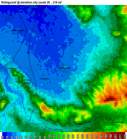
Below is the Elevation map of Rafelguaraf, which displays elevation range with different colors. Scale of the first map is from 26 to 218 m (85 to 715 ft) with average elevation of 70.3 meters (=231 ft) [note 1]
These maps also provides idea of topography and contour of this city, they are displayed at different zoom levels. More info about maps, scale and edge coordinates you can find below images.
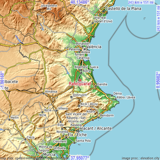
| \ | Map #1 | Topo.Map |
| Scale [m] | 26..218 m | × |
| Scale [ft] | 85..715 ft | × |
| Average | 70.3 m = 231 ft | × |
| Width | 7.59 km = 4.7 mi | 242.8 km = 150.9 mi |
| Height | 7.59 km = 4.7 mi | 242.8 km = 150.9 mi |
| ↑Max Latitude | 39.085379° | 40.13486° |
| Latitude at center | 39.05126° | 39.05126° |
| ↓Min Latitude | 39.017125° | 37.95077° |
| ← Min Longitude | -0.499375° | -1.86168° |
| Longitude center | -0.45543° | -0.45543° |
| →Max Longitude | -0.411485° | 0.95082° |
Nearby cities:
Cities around Rafelguaraf sort by population:
• Xàtiva elevation 108 m
8.7 km,  218°
218°
• Carcaixent 25 m
7.9 km,  4°
4°
• Villanueva de Castellón 41 m
5.7 km,  300°
300°
• La Pobla Llarga 33 m
3.7 km,  344°
344°
• Llosa de Ranes 129 m
7.9 km,  245°
245°
• Genovés 142 m
7 km,  190°
190°
• Manuel 63 m
3 km,  268°
268°
• Barxeta 145 m
5.1 km,  138°
138°
• Alcàntera de Xúquer 39 m
8.3 km,  281°
281°
• Senyera 43 m
4.2 km,  294°
294°
• Beneixida 39 m
8.3 km, 281°
• San Juan de Énova 40 m
3.5 km,  308°
308°
Multilingual:
 En español:
Rafelguaraf elevación 48 m.
 En France:
Rafelguaraf élévation 48 m.
 Auf Deutsch:
Rafelguaraf höhe über dem Meeresspiegel ist 48 m.

Sources and notes:
- [note 1] Map square and city borders are not equal. Map elevation data is calculated only from area inside that square.
- [src 1] Elevation data from geonames database provided with same terms of usage.
- [src 2] The elevation map of Rafelguaraf is generated using elevation data from NASA's 3 arcsec (90m) resolution SRTM data.
- [src 3] Base (background) map © OpenStreetMap contributors tiles are generated by Geofabrik and OpenTopoMap.
Copyright & License:
This Rafelguaraf Elevation Map is licensed under CC BY-SA. You may reuse any part from this page, if you give a proper credit by linking to this URL:
 More info on terms of use page.