Xàtiva elevation
Xàtiva (Valencia, Província de València), Spain elevation is 108 meters and Xàtiva elevation in feet is 354 ft above sea level [src 1]. Xàtiva is a seat of a third-order administrative division (feature code) with elevation that is 495 meters (1624 ft) smaller than average city elevation in Spain.
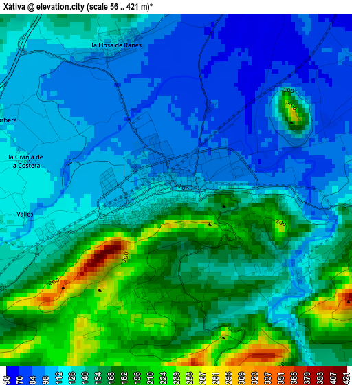
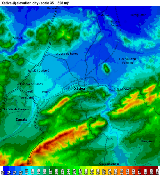
Below is the Elevation map of Xàtiva, which displays elevation range with different colors. Scale of the first map is from 56 to 421 m (184 to 1381 ft) with average elevation of 140 meters (=459 ft) [note 1]
These maps also provides idea of topography and contour of this city, they are displayed at different zoom levels. More info about maps, scale and edge coordinates you can find below images.
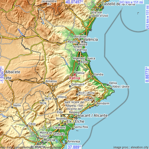
| \ | Map #1 | Map #2 | Topo.Map |
| Scale [m] | 56..421 m | 35..528 m | × |
| Scale [ft] | 184..1381 ft | 115..1732 ft | × |
| Average | 140 m = 459 ft | 159.5 m = 523 ft | × |
| Width | 7.6 km = 4.7 mi | 15.19 km = 9.4 mi | 243.1 km = 151.1 mi |
| Height | 7.6 km = 4.7 mi | 15.19 km = 9.4 mi | 243.1 km = 151.1 mi |
| ↑Max Latitude | 39.024568° | 39.0587° | 40.07497° |
| Latitude at center | 38.99042° | 38.99042° | 38.99042° |
| ↓Min Latitude | 38.956255° | 38.922074° | 37.889° |
| ← Min Longitude | -0.562465° | -0.606411° | -1.92477° |
| Longitude center | -0.51852° | -0.51852° | -0.51852° |
| →Max Longitude | -0.474575° | -0.430629° | 0.88773° |
Nearby cities:
Cities around Xàtiva sort by population:
• Canals elevation 166 m
6.5 km,  241°
241°
• L'Alcúdia de Crespìns 158 m
6.2 km, 244°
• Llosa de Ranes 129 m
3.9 km,  334°
334°
• Genovés 142 m
4.2 km,  91°
91°
• Manuel 63 m
7.1 km,  20°
20°
• Llanera de Ranes 164 m
4.9 km,  276°
276°
• Rotglá y Corbera 125 m
4.3 km,  291°
291°
• Sellent 88 m
7.6 km,  307°
307°
• Bellús 135 m
5.7 km,  151°
151°
• Cerdà 127 m
4.2 km,  259°
259°
• Torrella 128 m
4.3 km, 261°
• Vallés 121 m
3.4 km, 260°
Multilingual:
 En español:
Játiva elevación 108 m.
 En France:
Xàtiva élévation 108 m.


Sources and notes:
- [note 1] Map square and city borders are not equal. Map elevation data is calculated only from area inside that square.
- [src 1] Elevation data from geonames database provided with same terms of usage.
- [src 2] The elevation map of Xàtiva is generated using elevation data from NASA's 3 arcsec (90m) resolution SRTM data.
- [src 3] Base (background) map © OpenStreetMap contributors tiles are generated by Geofabrik and OpenTopoMap.
Copyright & License:
This Xàtiva Elevation Map is licensed under CC BY-SA. You may reuse any part from this page, if you give a proper credit by linking to this URL:
 More info on terms of use page.