Sagunto elevation
Sagunto (Valencia, Província de València), Spain elevation is 43 meters and Sagunto elevation in feet is 141 ft above sea level [src 1]. Sagunto is a populated place (feature code) with elevation that is 560 meters (1837 ft) smaller than average city elevation in Spain.
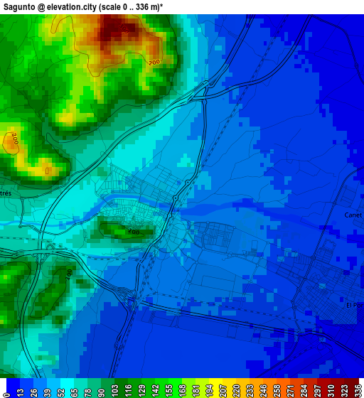
Below is the Elevation map of Sagunto, which displays elevation range with different colors. Scale of the first map is from 0 to 336 m (0 to 1102 ft) with average elevation of 57.7 meters (=189 ft) [note 1]
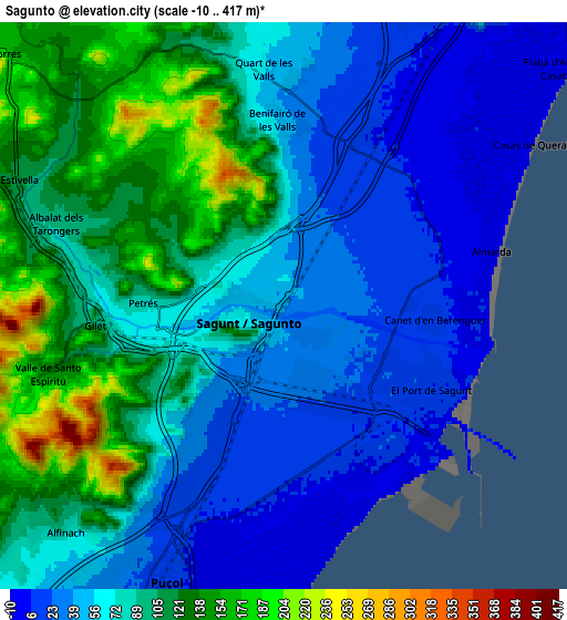
These maps also provides idea of topography and contour of this city, they are displayed at different zoom levels. More info about maps, scale and edge coordinates you can find below images.
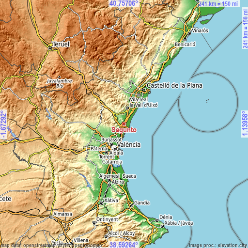
| \ | Map #1 | Map #2 | Topo.Map |
| Scale [m] | 0..336 m | -10..417 m | × |
| Scale [ft] | 0..1102 ft | -33..1368 ft | × |
| Average | 57.7 m = 189 ft | 76 m = 249 ft | × |
| Width | 7.52 km = 4.7 mi | 15.04 km = 9.3 mi | 240.7 km = 149.6 mi |
| Height | 7.52 km = 4.7 mi | 15.04 km = 9.3 mi | 240.7 km = 149.6 mi |
| ↑Max Latitude | 39.717141° | 39.750936° | 40.75706° |
| Latitude at center | 39.68333° | 39.68333° | 39.68333° |
| ↓Min Latitude | 39.649502° | 39.615658° | 38.59264° |
| ← Min Longitude | -0.310615° | -0.354561° | -1.67292° |
| Longitude center | -0.26667° | -0.26667° | -0.26667° |
| →Max Longitude | -0.222725° | -0.178779° | 1.13958° |
Nearby cities:
Cities around Sagunto sort by population:
• Grao de Murviedro elevation 3 m
5.2 km,  152°
152°
• Puçol 10 m
7.9 km,  201°
201°
• Canet d'En Berenguer 8 m
4.3 km,  90°
90°
• Faura 12 m
4 km,  21°
21°
• Gilet 82 m
4.3 km,  270°
270°
• Benifairó de les Valls 38 m
5.6 km,  0°
0°
• Quartell 46 m
6 km, 1°
• Estivella 119 m
8 km,  297°
297°
• Quart de les Valls 38 m
5.6 km, 0°
• Petrés 75 m
2.9 km, 270°
• Albalat dels Tarongers 93 m
6 km,  288°
288°
• Benavites 20 m
5.7 km,  14°
14°
Multilingual:
 En español:
Sagunto elevación 43 m.
 En France:
Sagonte élévation 43 m.


Sources and notes:
- [note 1] Map square and city borders are not equal. Map elevation data is calculated only from area inside that square.
- [src 1] Elevation data from geonames database provided with same terms of usage.
- [src 2] The elevation map of Sagunto is generated using elevation data from NASA's 3 arcsec (90m) resolution SRTM data.
- [src 3] Base (background) map © OpenStreetMap contributors tiles are generated by Geofabrik and OpenTopoMap.
Copyright & License:
This Sagunto Elevation Map is licensed under CC BY-SA. You may reuse any part from this page, if you give a proper credit by linking to this URL:
 More info on terms of use page.