Santa Brígida elevation
Santa Brígida (Canary Islands, Provincia de Las Palmas), Spain elevation is 499 meters and Santa Brígida elevation in feet is 1637 ft above sea level [src 1]. Santa Brígida is a seat of a third-order administrative division (feature code) with elevation that is 104 meters (341 ft) smaller than average city elevation in Spain.
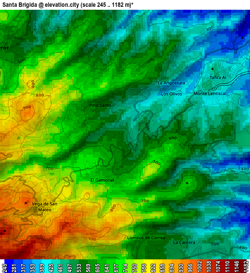
Below is the Elevation map of Santa Brígida, which displays elevation range with different colors. Scale of the first map is from 245 to 1182 m (804 to 3878 ft) with average elevation of 603.2 meters (=1979 ft) [note 1]
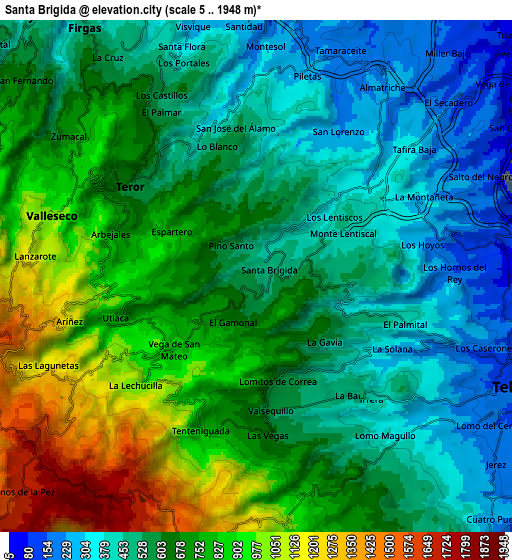
These maps also provides idea of topography and contour of this city, they are displayed at different zoom levels. More info about maps, scale and edge coordinates you can find below images.
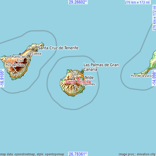
| \ | Map #1 | Map #2 | Topo.Map |
| Scale [m] | 245..1182 m | 5..1948 m | × |
| Scale [ft] | 804..3878 ft | 16..6391 ft | × |
| Average | 603.2 m = 1979 ft | 643.9 m = 2113 ft | × |
| Width | 8.63 km = 5.4 mi | 17.25 km = 10.7 mi | 276 km = 171.5 mi |
| Height | 8.63 km = 5.4 mi | 17.25 km = 10.7 mi | 276 km = 171.5 mi |
| ↑Max Latitude | 28.070753° | 28.109522° | 29.26602° |
| Latitude at center | 28.03197° | 28.03197° | 28.03197° |
| ↓Min Latitude | 27.993173° | 27.954362° | 26.78361° |
| ← Min Longitude | -15.548195° | -15.592141° | -16.9105° |
| Longitude center | -15.50425° | -15.50425° | -15.50425° |
| →Max Longitude | -15.460305° | -15.416359° | -14.098° |
Nearby cities:
Cities around Santa Brígida sort by population:
• Las Palmas de Gran Canaria elevation 23 m
11.7 km,  49°
49°
• Telde 160 m
9.4 km,  117°
117°
• Santa Lucía 699 m
13.8 km,  194°
194°
• San Bartolomé de Tirajana 902 m
13.7 km,  209°
209°
• Arucas 280 m
9.9 km,  349°
349°
• Teror 634 m
5.4 km,  305°
305°
• Valsequillo de Gran Canaria 601 m
5.2 km,  172°
172°
• Vega de San Mateo 848 m
3.8 km,  228°
228°
• Moya 282 m
11.7 km,  318°
318°
• Firgas 510 m
10.1 km,  325°
325°
• Valleseco 1067 m
7.2 km,  280°
280°
• Tejeda 1046 m
11.7 km,  249°
249°
Multilingual:
 En español:
Santa Brígida elevación 499 m.
 En France:
Santa Brígida élévation 499 m.
 Auf Deutsch:
Santa Brígida höhe über dem Meeresspiegel ist 499 m.

Sources and notes:
- [note 1] Map square and city borders are not equal. Map elevation data is calculated only from area inside that square.
- [src 1] Elevation data from geonames database provided with same terms of usage.
- [src 2] The elevation map of Santa Brígida is generated using elevation data from NASA's 3 arcsec (90m) resolution SRTM data.
- [src 3] Base (background) map © OpenStreetMap contributors tiles are generated by Geofabrik and OpenTopoMap.
Copyright & License:
This Santa Brígida Elevation Map is licensed under CC BY-SA. You may reuse any part from this page, if you give a proper credit by linking to this URL:
 More info on terms of use page.