Santa Pola elevation
Santa Pola (Valencia, Provincia de Alicante), Spain elevation is 7 meters and Santa Pola elevation in feet is 23 ft above sea level [src 1]. Santa Pola is a seat of a third-order administrative division (feature code) with elevation that is 596 meters (1955 ft) smaller than average city elevation in Spain.
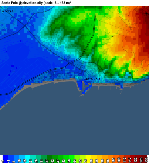
Below is the Elevation map of Santa Pola, which displays elevation range with different colors. Scale of the first map is from -6 to 133 m (-20 to 436 ft) with average elevation of 37.2 meters (=122 ft) [note 1]
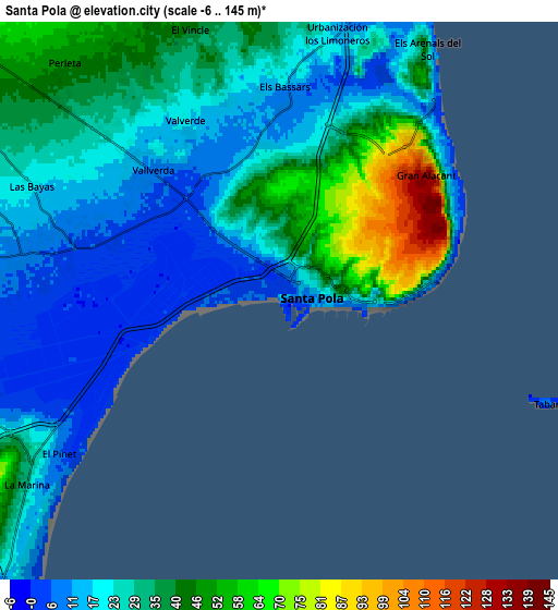
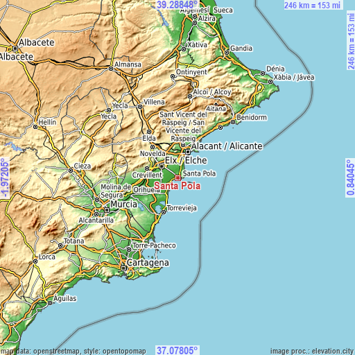
These maps also provides idea of topography and contour of this city, they are displayed at different zoom levels. More info about maps, scale and edge coordinates you can find below images.
| \ | Map #1 | Map #2 | Topo.Map |
| Scale [m] | -6..133 m | -6..145 m | × |
| Scale [ft] | -20..436 ft | -20..476 ft | × |
| Average | 37.2 m = 122 ft | 27.6 m = 91 ft | × |
| Width | 7.68 km = 4.8 mi | 15.36 km = 9.5 mi | 245.8 km = 152.7 mi |
| Height | 7.68 km = 4.8 mi | 15.36 km = 9.5 mi | 245.8 km = 152.7 mi |
| ↑Max Latitude | 38.22618° | 38.260695° | 39.28848° |
| Latitude at center | 38.19165° | 38.19165° | 38.19165° |
| ↓Min Latitude | 38.157103° | 38.12254° | 37.07805° |
| ← Min Longitude | -0.609745° | -0.653691° | -1.97205° |
| Longitude center | -0.5658° | -0.5658° | -0.5658° |
| →Max Longitude | -0.521855° | -0.477909° | 0.84045° |
Nearby cities:
Cities around Santa Pola sort by population:
• Alicante elevation 18 m
18.6 km,  23°
23°
• Elche 81 m
14.2 km,  303°
303°
• Crevillente 146 m
22.3 km,  286°
286°
• Rojales 12 m
18.1 km,  230°
230°
• Almoradí 17 m
21.8 km,  245°
245°
• Guardamar del Segura 35 m
13.7 km,  214°
214°
• Dolores 9 m
18.8 km, 252°
• Catral 11 m
20.9 km,  260°
260°
• Benijofar 43 m
19.6 km, 229°
• Formentera de Segura 11 m
19.7 km, 233°
• Daya Nueva 10 m
19.1 km,  242°
242°
• Daya Vieja 7 m
17.9 km, 237°
Multilingual:
 En español:
Santa Pola elevación 7 m.
 En France:
Santa Pola élévation 7 m.
 Auf Deutsch:
Santa Pola höhe über dem Meeresspiegel ist 7 m.

Sources and notes:
- [note 1] Map square and city borders are not equal. Map elevation data is calculated only from area inside that square.
- [src 1] Elevation data from geonames database provided with same terms of usage.
- [src 2] The elevation map of Santa Pola is generated using elevation data from NASA's 3 arcsec (90m) resolution SRTM data.
- [src 3] Base (background) map © OpenStreetMap contributors tiles are generated by Geofabrik and OpenTopoMap.
Copyright & License:
This Santa Pola Elevation Map is licensed under CC BY-SA. You may reuse any part from this page, if you give a proper credit by linking to this URL:
 More info on terms of use page.