Crevillente elevation
Crevillente (Valencia, Provincia de Alicante), Spain elevation is 146 meters and Crevillente elevation in feet is 479 ft above sea level [src 1]. Crevillente is a populated place (feature code) with elevation that is 457 meters (1499 ft) smaller than average city elevation in Spain.
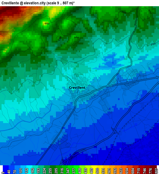
Below is the Elevation map of Crevillente, which displays elevation range with different colors. Scale of the first map is from 9 to 807 m (30 to 2648 ft) with average elevation of 166.7 meters (=547 ft) [note 1]
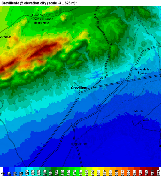
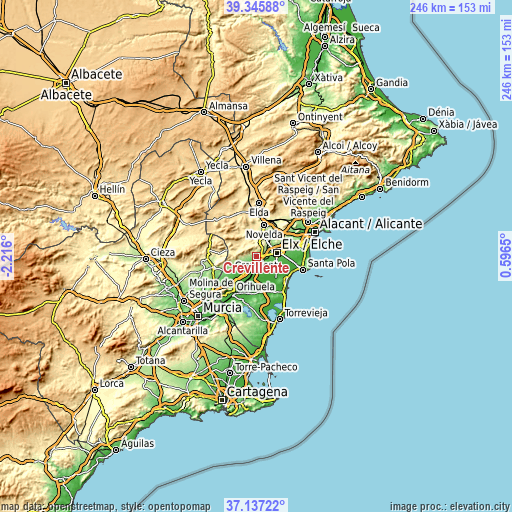
These maps also provides idea of topography and contour of this city, they are displayed at different zoom levels. More info about maps, scale and edge coordinates you can find below images.
| \ | Map #1 | Map #2 | Topo.Map |
| Scale [m] | 9..807 m | -3..823 m | × |
| Scale [ft] | 30..2648 ft | -10..2700 ft | × |
| Average | 166.7 m = 547 ft | 184.3 m = 605 ft | × |
| Width | 7.67 km = 4.8 mi | 15.35 km = 9.5 mi | 245.6 km = 152.6 mi |
| Height | 7.67 km = 4.8 mi | 15.35 km = 9.5 mi | 245.6 km = 152.6 mi |
| ↑Max Latitude | 38.284443° | 38.318929° | 39.34588° |
| Latitude at center | 38.24994° | 38.24994° | 38.24994° |
| ↓Min Latitude | 38.215421° | 38.180885° | 37.13722° |
| ← Min Longitude | -0.853695° | -0.897641° | -2.216° |
| Longitude center | -0.80975° | -0.80975° | -0.80975° |
| →Max Longitude | -0.765805° | -0.721859° | 0.5965° |
Nearby cities:
Cities around Crevillente sort by population:
• Elche elevation 81 m
9.6 km,  81°
81°
• Aspe 245 m
11.2 km,  19°
19°
• Callosa de Segura 23 m
15.1 km,  203°
203°
• Albatera 21 m
9.5 km,  213°
213°
• Dolores 9 m
12.7 km,  164°
164°
• Cox 22 m
13.8 km, 209°
• Catral 11 m
10 km,  176°
176°
• La Romana 429 m
15.2 km,  329°
329°
• Granja de Rocamora 20 m
13.1 km, 213°
• Hondón de las Nieves 376 m
7.5 km, 329°
• Hondón de los Frailes 423 m
10.8 km,  284°
284°
• San Isidro 9 m
9 km, 196°
Multilingual:
 En español:
Crevillente elevación 146 m.
 En France:
Crevillent élévation 146 m.
 Auf Deutsch:
Crevillente höhe über dem Meeresspiegel ist 146 m.

Sources and notes:
- [note 1] Map square and city borders are not equal. Map elevation data is calculated only from area inside that square.
- [src 1] Elevation data from geonames database provided with same terms of usage.
- [src 2] The elevation map of Crevillente is generated using elevation data from NASA's 3 arcsec (90m) resolution SRTM data.
- [src 3] Base (background) map © OpenStreetMap contributors tiles are generated by Geofabrik and OpenTopoMap.
Copyright & License:
This Crevillente Elevation Map is licensed under CC BY-SA. You may reuse any part from this page, if you give a proper credit by linking to this URL:
 More info on terms of use page.