Serra elevation
Serra (Valencia, Província de València), Spain elevation is 341 meters and Serra elevation in feet is 1119 ft above sea level [src 1]. Serra is a seat of a third-order administrative division (feature code) with elevation that is 262 meters (860 ft) smaller than average city elevation in Spain.
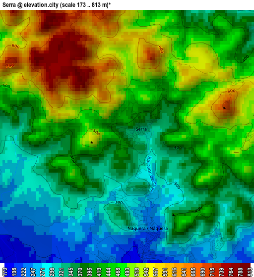
Below is the Elevation map of Serra, which displays elevation range with different colors. Scale of the first map is from 173 to 813 m (568 to 2667 ft) with average elevation of 422.8 meters (=1387 ft) [note 1]
These maps also provides idea of topography and contour of this city, they are displayed at different zoom levels. More info about maps, scale and edge coordinates you can find below images.
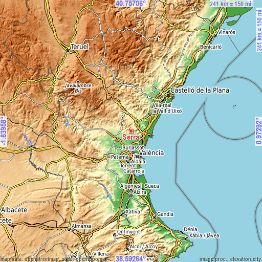
| \ | Map #1 | Topo.Map |
| Scale [m] | 173..813 m | × |
| Scale [ft] | 568..2667 ft | × |
| Average | 422.8 m = 1387 ft | × |
| Width | 7.52 km = 4.7 mi | 240.7 km = 149.6 mi |
| Height | 7.52 km = 4.7 mi | 240.7 km = 149.6 mi |
| ↑Max Latitude | 39.717141° | 40.75706° |
| Latitude at center | 39.68333° | 39.68333° |
| ↓Min Latitude | 39.649502° | 38.59264° |
| ← Min Longitude | -0.477275° | -1.83958° |
| Longitude center | -0.43333° | -0.43333° |
| →Max Longitude | -0.389385° | 0.97292° |
Nearby cities:
Cities around Serra sort by population:
• Bétera elevation 110 m
10.5 km,  193°
193°
• Náquera 220 m
4 km,  158°
158°
• Gilet 82 m
10 km,  90°
90°
• Marines 443 m
10.6 km,  307°
307°
• Estivella 119 m
8 km,  62°
62°
• Olocau 267 m
8.8 km,  282°
282°
• Algimia de Alfara 180 m
9.4 km,  37°
37°
• Petrés 75 m
11.4 km, 90°
• Albalat dels Tarongers 93 m
8.8 km,  77°
77°
• Sot de Ferrer 236 m
13.3 km,  12°
12°
• Alfara de Algimia 182 m
11.7 km, 37°
• Segart 256 m
5.7 km, 90°
Multilingual:
 En español:
Serra elevación 341 m.
 En France:
Serra élévation 341 m.


Sources and notes:
- [note 1] Map square and city borders are not equal. Map elevation data is calculated only from area inside that square.
- [src 1] Elevation data from geonames database provided with same terms of usage.
- [src 2] The elevation map of Serra is generated using elevation data from NASA's 3 arcsec (90m) resolution SRTM data.
- [src 3] Base (background) map © OpenStreetMap contributors tiles are generated by Geofabrik and OpenTopoMap.
Copyright & License:
This Serra Elevation Map is licensed under CC BY-SA. You may reuse any part from this page, if you give a proper credit by linking to this URL:
 More info on terms of use page.