Sot de Ferrer elevation
Sot de Ferrer (Valencia, Província de Castelló), Spain elevation is 236 meters and Sot de Ferrer elevation in feet is 774 ft above sea level [src 1]. Sot de Ferrer is a seat of a third-order administrative division (feature code) with elevation that is 367 meters (1204 ft) smaller than average city elevation in Spain.
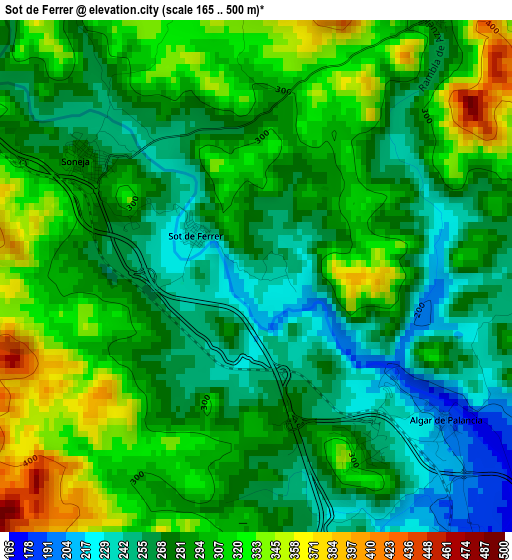
Below is the Elevation map of Sot de Ferrer, which displays elevation range with different colors. Scale of the first map is from 165 to 500 m (541 to 1640 ft) with average elevation of 288.4 meters (=946 ft) [note 1]
These maps also provides idea of topography and contour of this city, they are displayed at different zoom levels. More info about maps, scale and edge coordinates you can find below images.
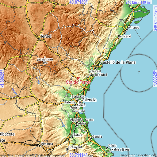
| \ | Map #1 | Topo.Map |
| Scale [m] | 165..500 m | × |
| Scale [ft] | 541..1640 ft | × |
| Average | 288.4 m = 946 ft | × |
| Width | 7.51 km = 4.7 mi | 240.3 km = 149.3 mi |
| Height | 7.51 km = 4.7 mi | 240.2 km = 149.3 mi |
| ↑Max Latitude | 39.833754° | 40.87189° |
| Latitude at center | 39.8° | 39.8° |
| ↓Min Latitude | 39.766229° | 38.71114° |
| ← Min Longitude | -0.443945° | -1.80625° |
| Longitude center | -0.4° | -0.4° |
| →Max Longitude | -0.356055° | 1.00625° |
Nearby cities:
Cities around Sot de Ferrer sort by population:
• Segorbe elevation 340 m
9 km,  307°
307°
• Altura 396 m
11.4 km,  299°
299°
• Soneja 251 m
2.3 km,  322°
322°
• Estivella 119 m
10.2 km,  155°
155°
• Castellnovo 386 m
8.6 km,  330°
330°
• Algimia de Alfara 180 m
6.2 km,  152°
152°
• Geldo 295 m
6.8 km, 303°
• Alfara de Algimia 182 m
5.7 km,  130°
130°
• Azuébar 295 m
4.7 km,  37°
37°
• Chóvar 417 m
9 km,  52°
52°
• Almedíjar 748 m
7.4 km,  0°
0°
• Vall de Almonacid 467 m
11.9 km,  339°
339°
Multilingual:
 En español:
Sot de Ferrer elevación 236 m.
 En France:
Sot de Ferrer élévation 236 m.
 Auf Deutsch:
Sot de Ferrer höhe über dem Meeresspiegel ist 236 m.

Sources and notes:
- [note 1] Map square and city borders are not equal. Map elevation data is calculated only from area inside that square.
- [src 1] Elevation data from geonames database provided with same terms of usage.
- [src 2] The elevation map of Sot de Ferrer is generated using elevation data from NASA's 3 arcsec (90m) resolution SRTM data.
- [src 3] Base (background) map © OpenStreetMap contributors tiles are generated by Geofabrik and OpenTopoMap.
Copyright & License:
This Sot de Ferrer Elevation Map is licensed under CC BY-SA. You may reuse any part from this page, if you give a proper credit by linking to this URL:
 More info on terms of use page.