Uclés elevation
Uclés (Castille-La Mancha, Provincia de Cuenca), Spain elevation is 846 meters and Uclés elevation in feet is 2776 ft above sea level [src 1]. Uclés is a seat of a third-order administrative division (feature code) with elevation that is 243 meters (797 ft) bigger than average city elevation in Spain.
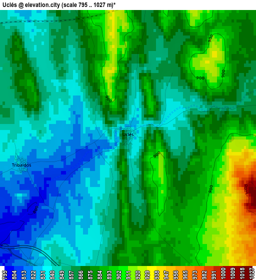
Below is the Elevation map of Uclés, which displays elevation range with different colors. Scale of the first map is from 795 to 1027 m (2608 to 3369 ft) with average elevation of 865.9 meters (=2841 ft) [note 1]
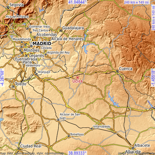
These maps also provides idea of topography and contour of this city, they are displayed at different zoom levels. More info about maps, scale and edge coordinates you can find below images.
| \ | Map #1 | Topo.Map |
| Scale [m] | 795..1027 m | × |
| Scale [ft] | 2608..3369 ft | × |
| Average | 865.9 m = 2841 ft | × |
| Width | 7.49 km = 4.7 mi | 239.6 km = 148.9 mi |
| Height | 7.49 km = 4.7 mi | 239.6 km = 148.9 mi |
| ↑Max Latitude | 40.013046° | 41.04844° |
| Latitude at center | 39.97938° | 39.97938° |
| ↓Min Latitude | 39.945697° | 38.89333° |
| ← Min Longitude | -2.905375° | -4.26768° |
| Longitude center | -2.86143° | -2.86143° |
| →Max Longitude | -2.817485° | -1.45518° |
Nearby cities:
Cities around Uclés sort by population:
• Tarancón elevation 817 m
12.8 km,  284°
284°
• Fuente de Pedro Naharro 774 m
14 km,  244°
244°
• Barajas de Melo 716 m
16.7 km,  343°
343°
• Saelices 929 m
8.1 km,  143°
143°
• Torrubia del Campo 805 m
12.5 km,  223°
223°
• Villarrubio 829 m
4.7 km, 216°
• Alcázar del Rey 874 m
10.3 km,  26°
26°
• Vellisca 943 m
17.2 km,  13°
13°
• Tribaldos 830 m
3.2 km,  256°
256°
• Rozalén del Monte 877 m
5 km,  75°
75°
• Paredes 835 m
9.6 km,  3°
3°
• Huelves 822 m
7.3 km, 344°
Multilingual:
 En español:
Uclés elevación 846 m.
 En France:
Uclès élévation 846 m.


Sources and notes:
- [note 1] Map square and city borders are not equal. Map elevation data is calculated only from area inside that square.
- [src 1] Elevation data from geonames database provided with same terms of usage.
- [src 2] The elevation map of Uclés is generated using elevation data from NASA's 3 arcsec (90m) resolution SRTM data.
- [src 3] Base (background) map © OpenStreetMap contributors tiles are generated by Geofabrik and OpenTopoMap.
Copyright & License:
This Uclés Elevation Map is licensed under CC BY-SA. You may reuse any part from this page, if you give a proper credit by linking to this URL:
 More info on terms of use page.