Macas elevation
Macas (Morona-Santiago, Cantón Morona), Ecuador elevation is 914 meters and Macas elevation in feet is 2999 ft above sea level [src 1]. Macas is a seat of a first-order administrative division (feature code) with elevation that is 31 meters (102 ft) smaller than average city elevation in Ecuador.
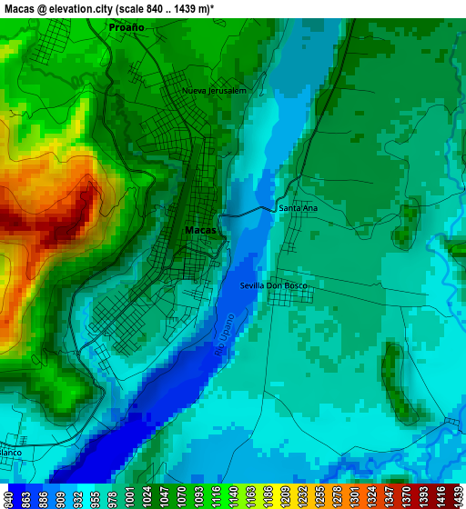
Below is the Elevation map of Macas, which displays elevation range with different colors. Scale of the first map is from 840 to 1439 m (2756 to 4721 ft) with average elevation of 1012.6 meters (=3322 ft) [note 1]
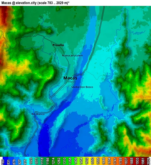
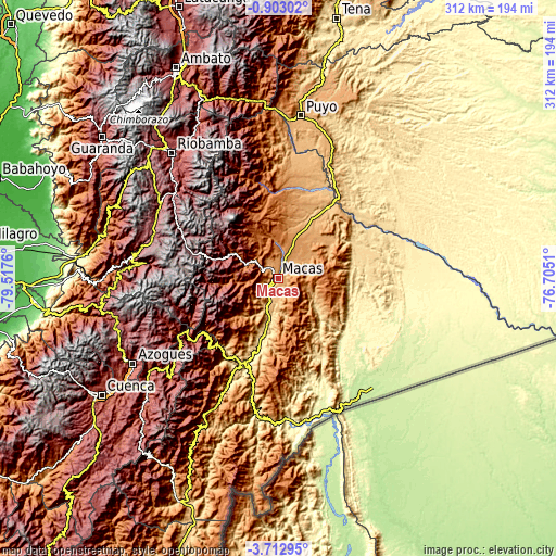
These maps also provides idea of topography and contour of this city, they are displayed at different zoom levels. More info about maps, scale and edge coordinates you can find below images.
| \ | Map #1 | Map #2 | Topo.Map |
| Scale [m] | 840..1439 m | 783..2029 m | × |
| Scale [ft] | 2756..4721 ft | 2569..6657 ft | × |
| Average | 1012.6 m = 3322 ft | 1114.9 m = 3658 ft | × |
| Width | 9.76 km = 6.1 mi | 19.53 km = 12.1 mi | 312.4 km = 194.1 mi |
| Height | 9.76 km = 6.1 mi | 19.53 km = 12.1 mi | 312.5 km = 194.2 mi |
| ↑Max Latitude | -2.26477° | -2.220858° | -0.90302° |
| Latitude at center | -2.30868° | -2.30868° | -2.30868° |
| ↓Min Latitude | -2.352589° | -2.396497° | -3.71295° |
| ← Min Longitude | -78.155295° | -78.199241° | -79.5176° |
| Longitude center | -78.11135° | -78.11135° | -78.11135° |
| →Max Longitude | -78.067405° | -78.023459° | -76.7051° |
Nearby cities:
Cities around Macas sort by population:
• Riobamba elevation 2758 m
92.6 km,  319°
319°
• Azogues 2508 m
94.9 km,  239°
239°
• Puyo 925 m
92.5 km,  7°
7°
• Gualaceo 2233 m
98.5 km,  228°
228°
• Alausí 2345 m
82.6 km,  278°
278°
• Guano 2666 m
97 km, 323°
• Cañar 3131 m
96.2 km,  253°
253°
• Sucúa 831 m
18 km,  201°
201°
• Palora 880 m
69.5 km, 13°
• Llacao 2524 m
105.8 km, 234°
• La Unión 2437 m
95.9 km, 231°
• Taisha 339 m
72.4 km,  92°
92°
Multilingual:
 En español:
Macas elevación 914 m.
 En France:
Macas élévation 914 m.


Sources and notes:
- [note 1] Map square and city borders are not equal. Map elevation data is calculated only from area inside that square.
- [src 1] Elevation data from geonames database provided with same terms of usage.
- [src 2] The elevation map of Macas is generated using elevation data from NASA's 3 arcsec (90m) resolution SRTM data.
- [src 3] Base (background) map © OpenStreetMap contributors tiles are generated by Geofabrik and OpenTopoMap.
Copyright & License:
This Macas Elevation Map is licensed under CC BY-SA. You may reuse any part from this page, if you give a proper credit by linking to this URL:
 More info on terms of use page.