La Unión elevation
La Unión (Azuay, Cantón Paute), Ecuador elevation is 2437 meters and La Unión elevation in feet is 7995 ft above sea level [src 1]. La Unión is a populated place (feature code) with elevation that is 1492 meters (4895 ft) bigger than average city elevation in Ecuador.
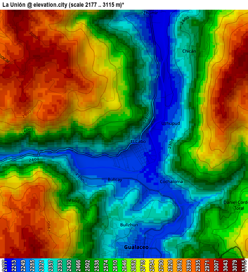
Below is the Elevation map of La Unión, which displays elevation range with different colors. Scale of the first map is from 2177 to 3115 m (7142 to 10220 ft) with average elevation of 2596.4 meters (=8518 ft) [note 1]
These maps also provides idea of topography and contour of this city, they are displayed at different zoom levels. More info about maps, scale and edge coordinates you can find below images.
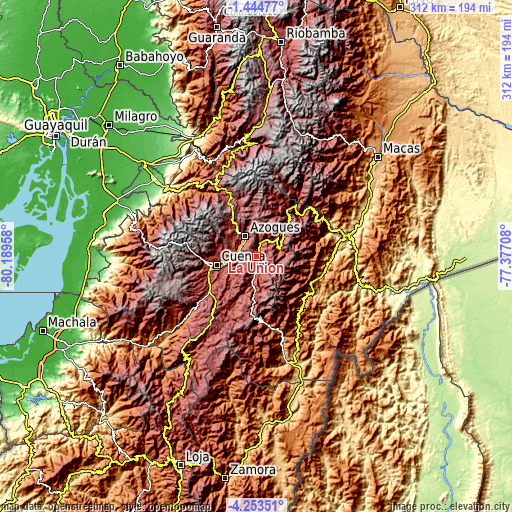
| \ | Map #1 | Topo.Map |
| Scale [m] | 2177..3115 m | × |
| Scale [ft] | 7142..10220 ft | × |
| Average | 2596.4 m = 8518 ft | × |
| Width | 9.76 km = 6.1 mi | 312.3 km = 194.1 mi |
| Height | 9.76 km = 6.1 mi | 312.3 km = 194.1 mi |
| ↑Max Latitude | -2.806108° | -1.44477° |
| Latitude at center | -2.85° | -2.85° |
| ↓Min Latitude | -2.89389° | -4.25351° |
| ← Min Longitude | -78.827275° | -80.18958° |
| Longitude center | -78.78333° | -78.78333° |
| →Max Longitude | -78.739385° | -77.37708° |
Nearby cities:
Cities around La Unión sort by population:
• Cuenca elevation 2543 m
25.2 km,  257°
257°
• La Troncal 82 m
77.9 km,  307°
307°
• Azogues 2508 m
14.2 km,  329°
329°
• Naranjal 25 m
94.8 km,  281°
281°
• Macas 914 m
95.9 km,  51°
51°
• Gualaceo 2233 m
4.8 km,  173°
173°
• Alausí 2345 m
72.3 km,  354°
354°
• Cañar 3131 m
36.5 km, 331°
• Sucúa 831 m
80.7 km,  57°
57°
• Gualaquiza 851 m
65.5 km,  160°
160°
• Nulti 3087 m
10.5 km,  224°
224°
• Llacao 2524 m
11.3 km, 260°
Multilingual:
 En español:
La Unión elevación 2437 m.
 En France:
La Unión élévation 2437 m.
 Auf Deutsch:
La Unión höhe über dem Meeresspiegel ist 2437 m.

Sources and notes:
- [note 1] Map square and city borders are not equal. Map elevation data is calculated only from area inside that square.
- [src 1] Elevation data from geonames database provided with same terms of usage.
- [src 2] The elevation map of La Unión is generated using elevation data from NASA's 3 arcsec (90m) resolution SRTM data.
- [src 3] Base (background) map © OpenStreetMap contributors tiles are generated by Geofabrik and OpenTopoMap.
Copyright & License:
This La Unión Elevation Map is licensed under CC BY-SA. You may reuse any part from this page, if you give a proper credit by linking to this URL:
 More info on terms of use page.