Aïn Oussera elevation
Aïn Oussera (Djelfa), Algeria elevation is 685 meters and Aïn Oussera elevation in feet is 2247 ft above sea level [src 1]. Aïn Oussera is a populated place (feature code) with elevation that is 247 meters (810 ft) bigger than average city elevation in Algeria.
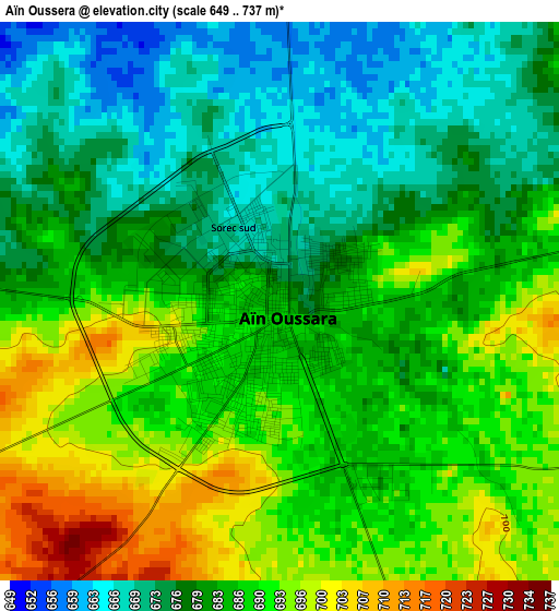
Below is the Elevation map of Aïn Oussera, which displays elevation range with different colors. Scale of the first map is from 649 to 737 m (2129 to 2418 ft) with average elevation of 684 meters (=2244 ft) [note 1]
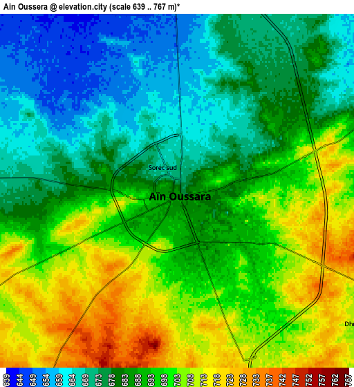
These maps also provides idea of topography and contour of this city, they are displayed at different zoom levels. More info about maps, scale and edge coordinates you can find below images.
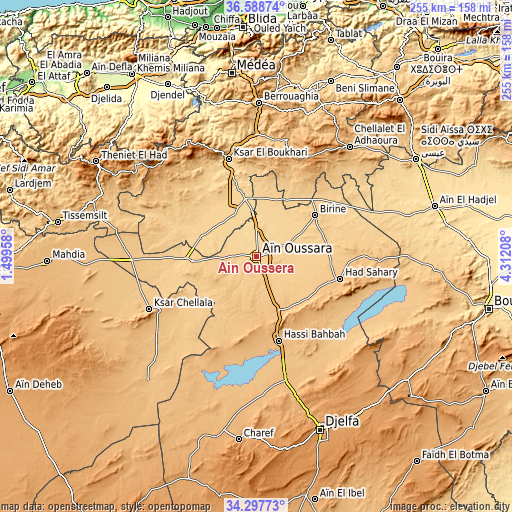
| \ | Map #1 | Map #2 | Topo.Map |
| Scale [m] | 649..737 m | 639..767 m | × |
| Scale [ft] | 2129..2418 ft | 2096..2516 ft | × |
| Average | 684 m = 2244 ft | 689.1 m = 2261 ft | × |
| Width | 7.96 km = 4.9 mi | 15.92 km = 9.9 mi | 254.7 km = 158.3 mi |
| Height | 7.96 km = 4.9 mi | 15.92 km = 9.9 mi | 254.7 km = 158.3 mi |
| ↑Max Latitude | 35.48718° | 35.522955° | 36.58874° |
| Latitude at center | 35.45139° | 35.45139° | 35.45139° |
| ↓Min Latitude | 35.415584° | 35.379762° | 34.29773° |
| ← Min Longitude | 2.861885° | 2.817939° | 1.49958° |
| Longitude center | 2.90583° | 2.90583° | 2.90583° |
| →Max Longitude | 2.949775° | 2.993721° | 4.31208° |
Nearby cities:
Cities around Aïn Oussera sort by population:
• Djelfa elevation 1138 m
92.5 km,  159°
159°
• Médéa 910 m
91.4 km,  351°
351°
• Berrouaghia 946 m
76 km,  0°
0°
• Ksar el Boukhari 621 m
50.7 km,  343°
343°
• Sidi Aïssa 662 m
92 km,  58°
58°
• Ksar Chellala 842 m
59.5 km,  243°
243°
• Dar Chioukh 1094 m
81.1 km,  139°
139°
• Birine 736 m
35.4 km,  54°
54°
• ‘Aïn el Hadjel 544 m
91.5 km,  74°
74°
• Charef 1157 m
92.9 km,  186°
186°
• Theniet el Had 1129 m
92 km,  300°
300°
• ’Aïn Boucif 1123 m
54 km,  25°
25°
Multilingual:
 En español:
Aïn Oussera elevación 685 m.
 En France:
Aïn Oussera élévation 685 m.
 Auf Deutsch:
Aïn Oussera höhe über dem Meeresspiegel ist 685 m.

Sources and notes:
- [note 1] Map square and city borders are not equal. Map elevation data is calculated only from area inside that square.
- [src 1] Elevation data from geonames database provided with same terms of usage.
- [src 2] The elevation map of Aïn Oussera is generated using elevation data from NASA's 3 arcsec (90m) resolution SRTM data.
- [src 3] Base (background) map © OpenStreetMap contributors tiles are generated by Geofabrik and OpenTopoMap.
Copyright & License:
This Aïn Oussera Elevation Map is licensed under CC BY-SA. You may reuse any part from this page, if you give a proper credit by linking to this URL:
 More info on terms of use page.