Berrouaghia elevation
Berrouaghia (Medea), Algeria elevation is 946 meters and Berrouaghia elevation in feet is 3104 ft above sea level [src 1]. Berrouaghia is a populated place (feature code) with elevation that is 508 meters (1667 ft) bigger than average city elevation in Algeria.
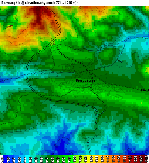
Below is the Elevation map of Berrouaghia, which displays elevation range with different colors. Scale of the first map is from 771 to 1245 m (2530 to 4085 ft) with average elevation of 935.2 meters (=3068 ft) [note 1]
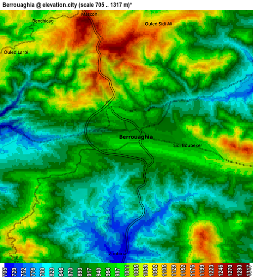
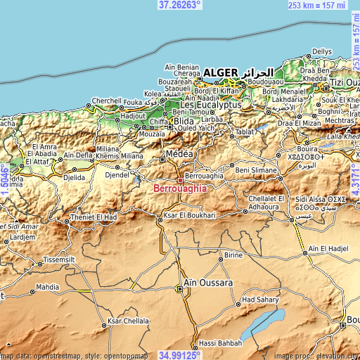
These maps also provides idea of topography and contour of this city, they are displayed at different zoom levels. More info about maps, scale and edge coordinates you can find below images.
| \ | Map #1 | Map #2 | Topo.Map |
| Scale [m] | 771..1245 m | 705..1317 m | × |
| Scale [ft] | 2530..4085 ft | 2313..4321 ft | × |
| Average | 935.2 m = 3068 ft | 945.1 m = 3101 ft | × |
| Width | 7.89 km = 4.9 mi | 15.79 km = 9.8 mi | 252.6 km = 157 mi |
| Height | 7.89 km = 4.9 mi | 15.79 km = 9.8 mi | 252.6 km = 157 mi |
| ↑Max Latitude | 36.170643° | 36.206111° | 37.26263° |
| Latitude at center | 36.13516° | 36.13516° | 36.13516° |
| ↓Min Latitude | 36.099661° | 36.064145° | 34.99125° |
| ← Min Longitude | 2.866905° | 2.822959° | 1.5046° |
| Longitude center | 2.91085° | 2.91085° | 2.91085° |
| →Max Longitude | 2.954795° | 2.998741° | 4.3171° |
Nearby cities:
Cities around Berrouaghia sort by population:
• Blida elevation 256 m
38 km,  348°
348°
• Médéa 910 m
20.1 km,  315°
315°
• Beni Mered 136 m
43.4 km, 354°
• Ksar el Boukhari 621 m
31 km,  207°
207°
• Bougara 110 m
47.7 km,  18°
18°
• Boû Arfa 241 m
37.5 km, 346°
• El Affroun 96 m
45.2 km,  325°
325°
• Souma 151 m
42.6 km,  359°
359°
• Mouzaïa 121 m
41.9 km, 331°
• Bouinan 92 m
44.7 km,  9°
9°
• Chiffa 110 m
39.6 km,  337°
337°
• ’Aïn Boucif 1123 m
35.1 km,  140°
140°
Multilingual:
 En español:
Berrouaghia elevación 946 m.
 En France:
Berrouaghia élévation 946 m.
 Auf Deutsch:
Berrouaghia höhe über dem Meeresspiegel ist 946 m.

Sources and notes:
- [note 1] Map square and city borders are not equal. Map elevation data is calculated only from area inside that square.
- [src 1] Elevation data from geonames database provided with same terms of usage.
- [src 2] The elevation map of Berrouaghia is generated using elevation data from NASA's 3 arcsec (90m) resolution SRTM data.
- [src 3] Base (background) map © OpenStreetMap contributors tiles are generated by Geofabrik and OpenTopoMap.
Copyright & License:
This Berrouaghia Elevation Map is licensed under CC BY-SA. You may reuse any part from this page, if you give a proper credit by linking to this URL:
 More info on terms of use page.