Bejaïa elevation
Bejaïa (Béjaïa), Algeria elevation is 86 meters and Bejaïa elevation in feet is 282 ft above sea level [src 1]. Bejaïa is a seat of a first-order administrative division (feature code) with elevation that is 352 meters (1155 ft) smaller than average city elevation in Algeria.
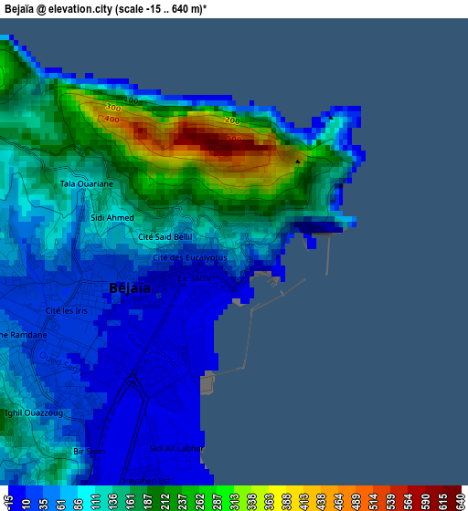
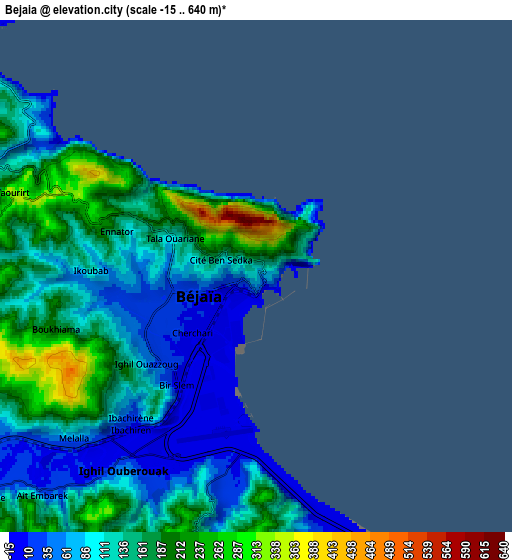
Below is the Elevation map of Bejaïa, which displays elevation range with different colors. Scale of the first map is from -15 to 640 m (-49 to 2100 ft) with average elevation of 114.7 meters (=376 ft) [note 1]
These maps also provides idea of topography and contour of this city, they are displayed at different zoom levels. More info about maps, scale and edge coordinates you can find below images.
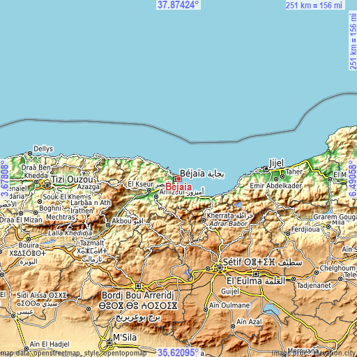
| \ | Map #1 | Map #2 | Topo.Map |
| Scale [m] | -15..640 m | -15..640 m | × |
| Scale [ft] | -49..2100 ft | -49..2100 ft | × |
| Average | 114.7 m = 376 ft | 129.2 m = 424 ft | × |
| Width | 7.83 km = 4.9 mi | 15.66 km = 9.7 mi | 250.5 km = 155.7 mi |
| Height | 7.83 km = 4.9 mi | 15.66 km = 9.7 mi | 250.5 km = 155.7 mi |
| ↑Max Latitude | 36.791071° | 36.826255° | 37.87424° |
| Latitude at center | 36.75587° | 36.75587° | 36.75587° |
| ↓Min Latitude | 36.720653° | 36.68542° | 35.62095° |
| ← Min Longitude | 5.040385° | 4.996439° | 3.67808° |
| Longitude center | 5.08433° | 5.08433° | 5.08433° |
| →Max Longitude | 5.128275° | 5.172221° | 6.49058° |
Nearby cities:
Cities around Bejaïa sort by population:
• Akbou elevation 215 m
59.2 km,  235°
235°
• Bougaa 859 m
47 km,  179°
179°
• BABOR - VILLE 944 m
50.2 km,  126°
126°
• Barbacha 571 m
23.5 km,  206°
206°
• el hed 94 m
30.1 km,  246°
246°
• El Kseur 84 m
22.1 km, 247°
• Amizour 96 m
20.8 km,  231°
231°
• Feraoun 652 m
29.9 km,  223°
223°
• Chemini 852 m
45.2 km, 247°
• Seddouk 353 m
42.4 km, 236°
• Bordj Zemoura 1043 m
57.2 km,  200°
200°
• Ighram 334 m
61.1 km, 237°
Multilingual:
 En español:
Bugía elevación 86 m.
 En France:
Béjaïa élévation 86 m.
 Auf Deutsch:
Bejaia, Bidschāya höhe über dem Meeresspiegel ist 86 m.

Sources and notes:
- [note 1] Map square and city borders are not equal. Map elevation data is calculated only from area inside that square.
- [src 1] Elevation data from geonames database provided with same terms of usage.
- [src 2] The elevation map of Bejaïa is generated using elevation data from NASA's 3 arcsec (90m) resolution SRTM data.
- [src 3] Base (background) map © OpenStreetMap contributors tiles are generated by Geofabrik and OpenTopoMap.
Copyright & License:
This Bejaïa Elevation Map is licensed under CC BY-SA. You may reuse any part from this page, if you give a proper credit by linking to this URL:
 More info on terms of use page.