Bougaa elevation
Bougaa (Sétif), Algeria elevation is 859 meters and Bougaa elevation in feet is 2818 ft above sea level [src 1]. Bougaa is a populated place (feature code) with elevation that is 421 meters (1381 ft) bigger than average city elevation in Algeria.
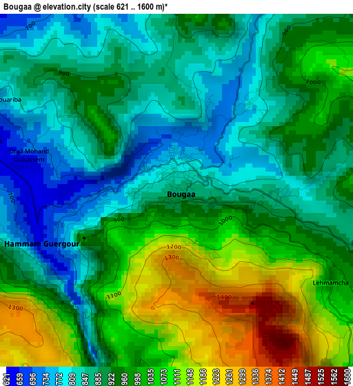
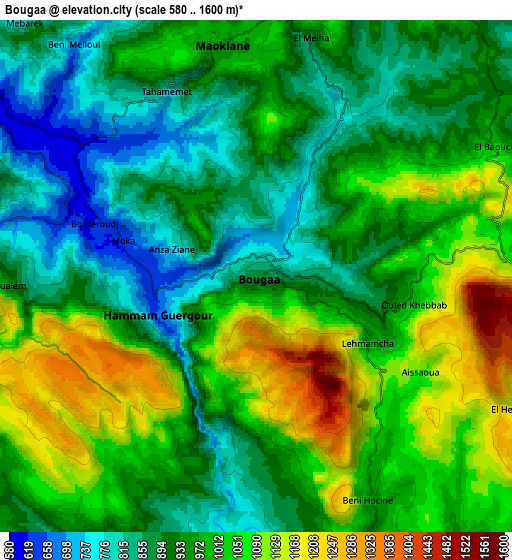
Below is the Elevation map of Bougaa, which displays elevation range with different colors. Scale of the first map is from 621 to 1600 m (2037 to 5249 ft) with average elevation of 952 meters (=3123 ft) [note 1]
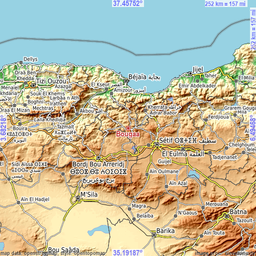
These maps also provides idea of topography and contour of this city, they are displayed at different zoom levels. More info about maps, scale and edge coordinates you can find below images.
| \ | Map #1 | Map #2 | Topo.Map |
| Scale [m] | 621..1600 m | 580..1600 m | × |
| Scale [ft] | 2037..5249 ft | 1903..5249 ft | × |
| Average | 952 m = 3123 ft | 968.6 m = 3178 ft | × |
| Width | 7.87 km = 4.9 mi | 15.75 km = 9.8 mi | 251.9 km = 156.5 mi |
| Height | 7.87 km = 4.9 mi | 15.75 km = 9.8 mi | 251.9 km = 156.5 mi |
| ↑Max Latitude | 36.368324° | 36.403701° | 37.45752° |
| Latitude at center | 36.33293° | 36.33293° | 36.33293° |
| ↓Min Latitude | 36.29752° | 36.262094° | 35.19187° |
| ← Min Longitude | 5.044485° | 5.000539° | 3.68218° |
| Longitude center | 5.08843° | 5.08843° | 5.08843° |
| →Max Longitude | 5.132375° | 5.176321° | 6.49468° |
Nearby cities:
Cities around Bougaa sort by population:
• Sétif elevation 1096 m
33.2 km,  118°
118°
• Bordj Bou Arreridj 906 m
41.2 km,  225°
225°
• Râs el Oued 1102 m
43.5 km,  186°
186°
• Aïn Arnat 1022 m
25.9 km,  128°
128°
• BABOR - VILLE 944 m
44 km,  66°
66°
• Barbacha 571 m
28.2 km,  337°
337°
• el hed 94 m
45.1 km,  321°
321°
• El Kseur 84 m
43.8 km,  331°
331°
• Amizour 96 m
38 km, 333°
• Feraoun 652 m
32.8 km, 320°
• Seddouk 353 m
43.2 km,  303°
303°
• Bordj Zemoura 1043 m
21.8 km,  252°
252°
Multilingual:
 En español:
Bougaa elevación 859 m.
 En France:
Bougaa élévation 859 m.


Sources and notes:
- [note 1] Map square and city borders are not equal. Map elevation data is calculated only from area inside that square.
- [src 1] Elevation data from geonames database provided with same terms of usage.
- [src 2] The elevation map of Bougaa is generated using elevation data from NASA's 3 arcsec (90m) resolution SRTM data.
- [src 3] Base (background) map © OpenStreetMap contributors tiles are generated by Geofabrik and OpenTopoMap.
Copyright & License:
This Bougaa Elevation Map is licensed under CC BY-SA. You may reuse any part from this page, if you give a proper credit by linking to this URL:
 More info on terms of use page.