Aïn Arnat elevation
Aïn Arnat (Sétif), Algeria elevation is 1022 meters and Aïn Arnat elevation in feet is 3353 ft above sea level [src 1]. Aïn Arnat is a populated place (feature code) with elevation that is 584 meters (1916 ft) bigger than average city elevation in Algeria.
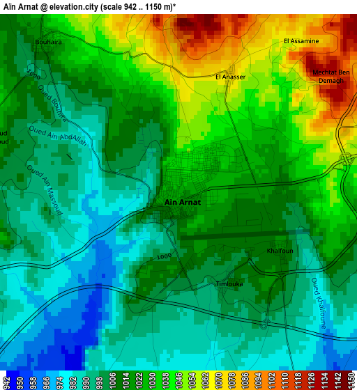
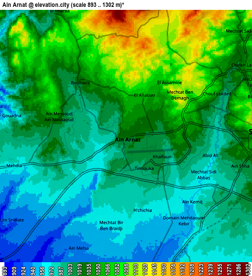
Below is the Elevation map of Aïn Arnat, which displays elevation range with different colors. Scale of the first map is from 942 to 1150 m (3091 to 3773 ft) with average elevation of 1015.4 meters (=3331 ft) [note 1]
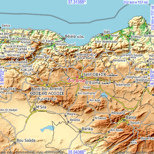
These maps also provides idea of topography and contour of this city, they are displayed at different zoom levels. More info about maps, scale and edge coordinates you can find below images.
| \ | Map #1 | Map #2 | Topo.Map |
| Scale [m] | 942..1150 m | 893..1302 m | × |
| Scale [ft] | 3091..3773 ft | 2930..4272 ft | × |
| Average | 1015.4 m = 3331 ft | 1019.2 m = 3344 ft | × |
| Width | 7.89 km = 4.9 mi | 15.77 km = 9.8 mi | 252.4 km = 156.8 mi |
| Height | 7.89 km = 4.9 mi | 15.77 km = 9.8 mi | 252.4 km = 156.8 mi |
| ↑Max Latitude | 36.22229° | 36.257734° | 37.31355° |
| Latitude at center | 36.18683° | 36.18683° | 36.18683° |
| ↓Min Latitude | 36.151354° | 36.115862° | 35.04366° |
| ← Min Longitude | 5.269525° | 5.225579° | 3.90722° |
| Longitude center | 5.31347° | 5.31347° | 5.31347° |
| →Max Longitude | 5.357415° | 5.401361° | 6.71972° |
Nearby cities:
Cities around Aïn Arnat sort by population:
• Sétif elevation 1096 m
9 km,  86°
86°
• Bordj Bou Arreridj 906 m
51.2 km,  255°
255°
• El Eulma 959 m
34 km,  96°
96°
• Râs el Oued 1102 m
37 km,  223°
223°
• Bougaa 859 m
25.9 km,  308°
308°
• Bordj Ghdir 1088 m
49 km,  229°
229°
• BABOR - VILLE 944 m
39.3 km,  30°
30°
• Barbacha 571 m
52.4 km,  323°
323°
• Amizour 96 m
62.5 km, 323°
• Salah Bey 976 m
37 km,  183°
183°
• Feraoun 652 m
58.4 km, 315°
• Bordj Zemoura 1043 m
42.1 km,  283°
283°
Multilingual:
 En español:
Aïn Arnat elevación 1022 m.
 En France:
Aïn Arnat élévation 1022 m.
 Auf Deutsch:
Aïn Arnat höhe über dem Meeresspiegel ist 1022 m.

Sources and notes:
- [note 1] Map square and city borders are not equal. Map elevation data is calculated only from area inside that square.
- [src 1] Elevation data from geonames database provided with same terms of usage.
- [src 2] The elevation map of Aïn Arnat is generated using elevation data from NASA's 3 arcsec (90m) resolution SRTM data.
- [src 3] Base (background) map © OpenStreetMap contributors tiles are generated by Geofabrik and OpenTopoMap.
Copyright & License:
This Aïn Arnat Elevation Map is licensed under CC BY-SA. You may reuse any part from this page, if you give a proper credit by linking to this URL:
 More info on terms of use page.