Oued el Abtal elevation
Oued el Abtal (Mascara), Algeria elevation is 259 meters and Oued el Abtal elevation in feet is 850 ft above sea level [src 1]. Oued el Abtal is a populated place (feature code) with elevation that is 179 meters (587 ft) smaller than average city elevation in Algeria.
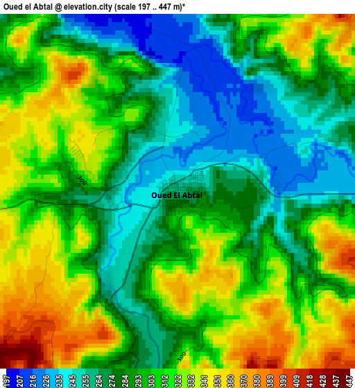
Below is the Elevation map of Oued el Abtal, which displays elevation range with different colors. Scale of the first map is from 197 to 447 m (646 to 1467 ft) with average elevation of 298 meters (=978 ft) [note 1]
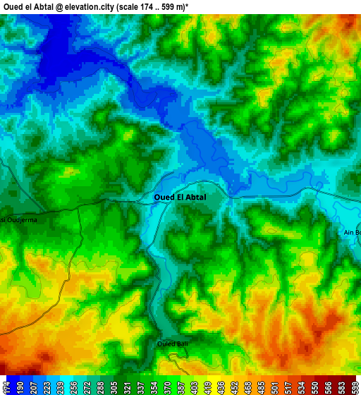
These maps also provides idea of topography and contour of this city, they are displayed at different zoom levels. More info about maps, scale and edge coordinates you can find below images.
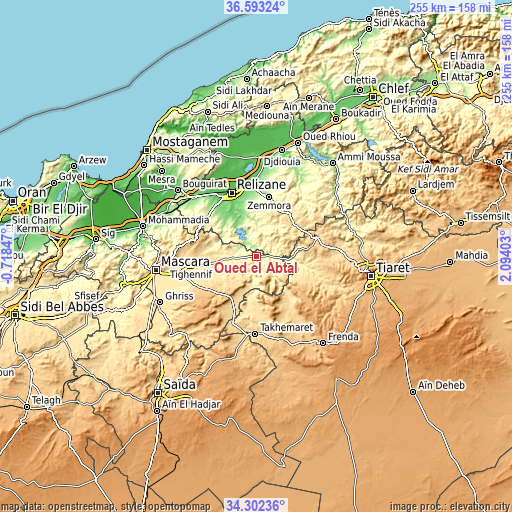
| \ | Map #1 | Map #2 | Topo.Map |
| Scale [m] | 197..447 m | 174..599 m | × |
| Scale [ft] | 646..1467 ft | 571..1965 ft | × |
| Average | 298 m = 978 ft | 335.1 m = 1099 ft | × |
| Width | 7.96 km = 4.9 mi | 15.92 km = 9.9 mi | 254.7 km = 158.3 mi |
| Height | 7.96 km = 4.9 mi | 15.92 km = 9.9 mi | 254.7 km = 158.3 mi |
| ↑Max Latitude | 35.491738° | 35.52751° | 36.59324° |
| Latitude at center | 35.45595° | 35.45595° | 35.45595° |
| ↓Min Latitude | 35.420146° | 35.384326° | 34.30236° |
| ← Min Longitude | 0.643835° | 0.599889° | -0.71847° |
| Longitude center | 0.68778° | 0.68778° | 0.68778° |
| →Max Longitude | 0.731725° | 0.775671° | 2.09403° |
Nearby cities:
Cities around Oued el Abtal sort by population:
• Tiaret elevation 1031 m
57.8 km,  99°
99°
• Mascara 590 m
50 km,  262°
262°
• Relizane 98 m
33.5 km,  339°
339°
• Mostaganem 102 m
75.6 km,  314°
314°
• Frenda 1058 m
54.4 km,  142°
142°
• Oued Rhiou 97 m
59.9 km,  20°
20°
• Djidiouia 70 m
54.2 km,  13°
13°
• Bou Hanifia el Hamamat 232 m
68.7 km, 256°
• Ammi Moussa 157 m
59.7 km,  39°
39°
• Zemoura 288 m
30.3 km, 11°
• Djebilet Rosfa 905 m
67.2 km,  168°
168°
• Smala 323 m
29.6 km, 11°
Multilingual:
 En español:
Oued el Abtal elevación 259 m.
 En France:
Oued el Abtal élévation 259 m.
 Auf Deutsch:
Oued el Abtal höhe über dem Meeresspiegel ist 259 m.

Sources and notes:
- [note 1] Map square and city borders are not equal. Map elevation data is calculated only from area inside that square.
- [src 1] Elevation data from geonames database provided with same terms of usage.
- [src 2] The elevation map of Oued el Abtal is generated using elevation data from NASA's 3 arcsec (90m) resolution SRTM data.
- [src 3] Base (background) map © OpenStreetMap contributors tiles are generated by Geofabrik and OpenTopoMap.
Copyright & License:
This Oued el Abtal Elevation Map is licensed under CC BY-SA. You may reuse any part from this page, if you give a proper credit by linking to this URL:
 More info on terms of use page.