Relizane elevation
Relizane, Algeria elevation is 98 meters and Relizane elevation in feet is 322 ft above sea level [src 1]. Relizane is a seat of a first-order administrative division (feature code) with elevation that is 340 meters (1115 ft) smaller than average city elevation in Algeria.
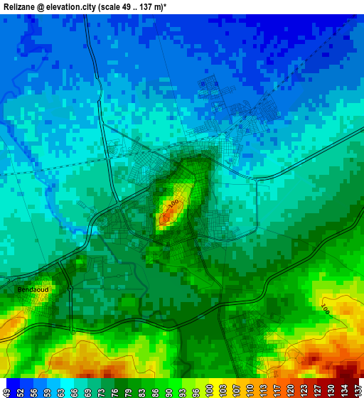
Below is the Elevation map of Relizane, which displays elevation range with different colors. Scale of the first map is from 49 to 137 m (161 to 449 ft) with average elevation of 72 meters (=236 ft) [note 1]
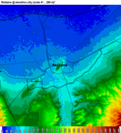
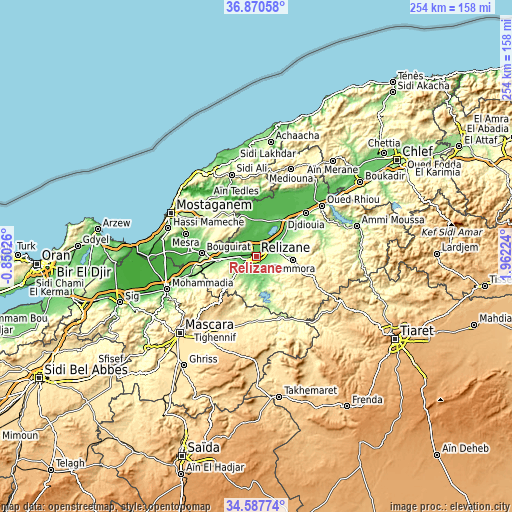
These maps also provides idea of topography and contour of this city, they are displayed at different zoom levels. More info about maps, scale and edge coordinates you can find below images.
| \ | Map #1 | Map #2 | Topo.Map |
| Scale [m] | 49..137 m | 41..266 m | × |
| Scale [ft] | 161..449 ft | 135..873 ft | × |
| Average | 72 m = 236 ft | 84.2 m = 276 ft | × |
| Width | 7.93 km = 4.9 mi | 15.86 km = 9.9 mi | 253.8 km = 157.7 mi |
| Height | 7.93 km = 4.9 mi | 15.86 km = 9.9 mi | 253.8 km = 157.7 mi |
| ↑Max Latitude | 35.773003° | 35.808649° | 36.87058° |
| Latitude at center | 35.73734° | 35.73734° | 35.73734° |
| ↓Min Latitude | 35.701661° | 35.665967° | 34.58774° |
| ← Min Longitude | 0.512045° | 0.468099° | -0.85026° |
| Longitude center | 0.55599° | 0.55599° | 0.55599° |
| →Max Longitude | 0.599935° | 0.643881° | 1.96224° |
Nearby cities:
Cities around Relizane sort by population:
• Mascara elevation 590 m
53.4 km,  224°
224°
• Mostaganem 102 m
47.3 km,  297°
297°
• Oued Rhiou 97 m
41.1 km,  52°
52°
• ’Aïn Merane 504 m
60.2 km,  38°
38°
• Djidiouia 70 m
32.6 km, 48°
• Oued Sly 90 m
70.7 km,  55°
55°
• Boukadir 79 m
63 km, 54°
• Ammi Moussa 157 m
52.1 km,  73°
73°
• Oued el Abtal 259 m
33.5 km,  159°
159°
• Mazouna 342 m
52.8 km, 35°
• Zemoura 288 m
18 km,  95°
95°
• Smala 323 m
18.1 km, 97°
Multilingual:
 En español:
Relizane elevación 98 m.
 En France:
Relizane élévation 98 m.


Sources and notes:
- [note 1] Map square and city borders are not equal. Map elevation data is calculated only from area inside that square.
- [src 1] Elevation data from geonames database provided with same terms of usage.
- [src 2] The elevation map of Relizane is generated using elevation data from NASA's 3 arcsec (90m) resolution SRTM data.
- [src 3] Base (background) map © OpenStreetMap contributors tiles are generated by Geofabrik and OpenTopoMap.
Copyright & License:
This Relizane Elevation Map is licensed under CC BY-SA. You may reuse any part from this page, if you give a proper credit by linking to this URL:
 More info on terms of use page.