Azua elevation
Azua, Dominican Republic elevation is 86 meters and Azua elevation in feet is 282 ft above sea level [src 1]. Azua is a seat of a first-order administrative division (feature code) with elevation that is 77 meters (253 ft) smaller than average city elevation in Dominican Republic.
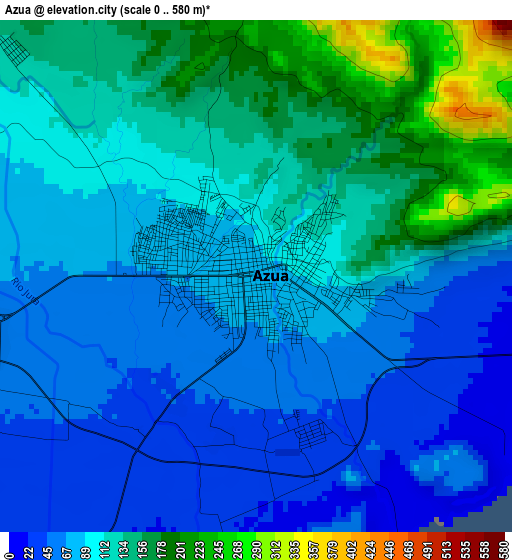
Below is the Elevation map of Azua, which displays elevation range with different colors. Scale of the first map is from 0 to 580 m (0 to 1903 ft) with average elevation of 102.4 meters (=336 ft) [note 1]
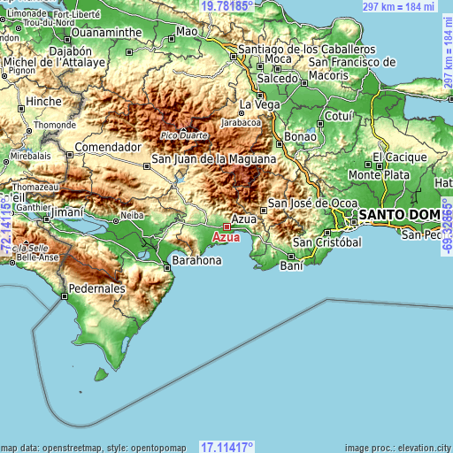
These maps also provides idea of topography and contour of this city, they are displayed at different zoom levels. More info about maps, scale and edge coordinates you can find below images.
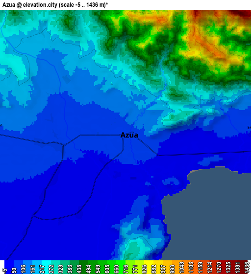
| \ | Map #1 | Map #2 | Topo.Map |
| Scale [m] | 0..580 m | -5..1436 m | × |
| Scale [ft] | 0..1903 ft | -16..4711 ft | × |
| Average | 102.4 m = 336 ft | 208 m = 682 ft | × |
| Width | 9.27 km = 5.8 mi | 18.54 km = 11.5 mi | 296.6 km = 184.3 mi |
| Height | 9.27 km = 5.8 mi | 18.54 km = 11.5 mi | 296.6 km = 184.3 mi |
| ↑Max Latitude | 18.494871° | 18.536541° | 19.78185° |
| Latitude at center | 18.45319° | 18.45319° | 18.45319° |
| ↓Min Latitude | 18.411499° | 18.369798° | 17.11417° |
| ← Min Longitude | -70.778845° | -70.822791° | -72.14115° |
| Longitude center | -70.7349° | -70.7349° | -70.7349° |
| →Max Longitude | -70.690955° | -70.647009° | -69.32865° |
Nearby cities:
Cities around Azua sort by population:
• San José de Ocoa elevation 481 m
26.2 km,  66°
66°
• Padre Las Casas 518 m
37.7 km,  325°
325°
• Peralta 482 m
14.8 km,  345°
345°
• Yayas de Viajama 317 m
26.6 km,  310°
310°
• Estebanía 61 m
9.7 km,  87°
87°
• Las Charcas 68 m
12.4 km, 91°
• Pueblo Viejo 24 m
6.8 km,  210°
210°
• Tábara Arriba 296 m
20.1 km, 310°
• Villarpando 287 m
39.4 km, 305°
• El Guayabal 727 m
34.7 km,  341°
341°
• Sabana Buey 78 m
29.9 km,  131°
131°
• Palmar de Ocoa 5 m
23.4 km,  138°
138°
Multilingual:
 En español:
Azua elevación 86 m.
 En France:
Azua élévation 86 m.


Sources and notes:
- [note 1] Map square and city borders are not equal. Map elevation data is calculated only from area inside that square.
- [src 1] Elevation data from geonames database provided with same terms of usage.
- [src 2] The elevation map of Azua is generated using elevation data from NASA's 3 arcsec (90m) resolution SRTM data.
- [src 3] Base (background) map © OpenStreetMap contributors tiles are generated by Geofabrik and OpenTopoMap.
Copyright & License:
This Azua Elevation Map is licensed under CC BY-SA. You may reuse any part from this page, if you give a proper credit by linking to this URL:
 More info on terms of use page.