San José de Ocoa elevation
San José de Ocoa, Dominican Republic elevation is 481 meters and San José de Ocoa elevation in feet is 1578 ft above sea level [src 1]. San José de Ocoa is a seat of a first-order administrative division (feature code) with elevation that is 318 meters (1043 ft) bigger than average city elevation in Dominican Republic.
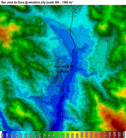
Below is the Elevation map of San José de Ocoa, which displays elevation range with different colors. Scale of the first map is from 360 to 1366 m (1181 to 4482 ft) with average elevation of 637.1 meters (=2090 ft) [note 1]
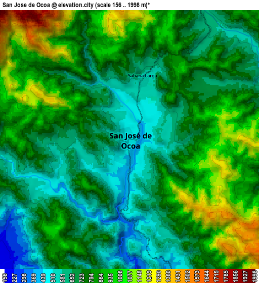
These maps also provides idea of topography and contour of this city, they are displayed at different zoom levels. More info about maps, scale and edge coordinates you can find below images.
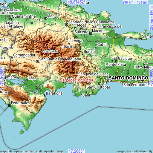
| \ | Map #1 | Map #2 | Topo.Map |
| Scale [m] | 360..1366 m | 156..1998 m | × |
| Scale [ft] | 1181..4482 ft | 512..6555 ft | × |
| Average | 637.1 m = 2090 ft | 789.9 m = 2592 ft | × |
| Width | 9.26 km = 5.8 mi | 18.53 km = 11.5 mi | 296.5 km = 184.2 mi |
| Height | 9.26 km = 5.8 mi | 18.53 km = 11.5 mi | 296.5 km = 184.2 mi |
| ↑Max Latitude | 18.588268° | 18.629916° | 19.87452° |
| Latitude at center | 18.54661° | 18.54661° | 18.54661° |
| ↓Min Latitude | 18.504942° | 18.463264° | 17.2083° |
| ← Min Longitude | -70.550255° | -70.594201° | -71.91256° |
| Longitude center | -70.50631° | -70.50631° | -70.50631° |
| →Max Longitude | -70.462365° | -70.418419° | -69.10006° |
Nearby cities:
Cities around San José de Ocoa sort by population:
• Baní elevation 67 m
34.9 km,  148°
148°
• Azua 86 m
26.2 km,  246°
246°
• Cambita Garabitos 184 m
34 km,  107°
107°
• Peralta 482 m
28.1 km,  277°
277°
• Estebanía 61 m
17.5 km,  235°
235°
• Las Charcas 68 m
15.9 km,  227°
227°
• Pueblo Viejo 24 m
32 km, 239°
• Matanzas 39 m
35 km,  164°
164°
• Sabana Buey 78 m
30.4 km,  183°
183°
• Palmar de Ocoa 5 m
29.1 km,  196°
196°
• El Cacao 403 m
22.3 km,  95°
95°
• Juan Adrián 356 m
30 km,  36°
36°
Multilingual:
 En español:
San José de Ocoa elevación 481 m.
 En France:
San José de Ocoa élévation 481 m.
 Auf Deutsch:
San José de Ocoa höhe über dem Meeresspiegel ist 481 m.

Sources and notes:
- [note 1] Map square and city borders are not equal. Map elevation data is calculated only from area inside that square.
- [src 1] Elevation data from geonames database provided with same terms of usage.
- [src 2] The elevation map of San José de Ocoa is generated using elevation data from NASA's 3 arcsec (90m) resolution SRTM data.
- [src 3] Base (background) map © OpenStreetMap contributors tiles are generated by Geofabrik and OpenTopoMap.
Copyright & License:
This San José de Ocoa Elevation Map is licensed under CC BY-SA. You may reuse any part from this page, if you give a proper credit by linking to this URL:
 More info on terms of use page.