Matanzas elevation
Matanzas (Peravia, Baní), Dominican Republic elevation is 39 meters and Matanzas elevation in feet is 128 ft above sea level [src 1]. Matanzas is a populated place (feature code) with elevation that is 124 meters (407 ft) smaller than average city elevation in Dominican Republic.
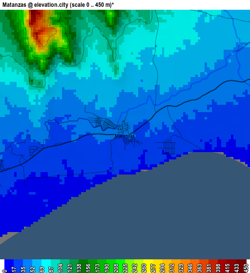
Below is the Elevation map of Matanzas, which displays elevation range with different colors. Scale of the first map is from 0 to 450 m (0 to 1476 ft) with average elevation of 63.4 meters (=208 ft) [note 1]
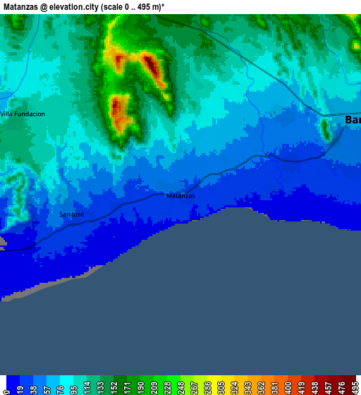
These maps also provides idea of topography and contour of this city, they are displayed at different zoom levels. More info about maps, scale and edge coordinates you can find below images.
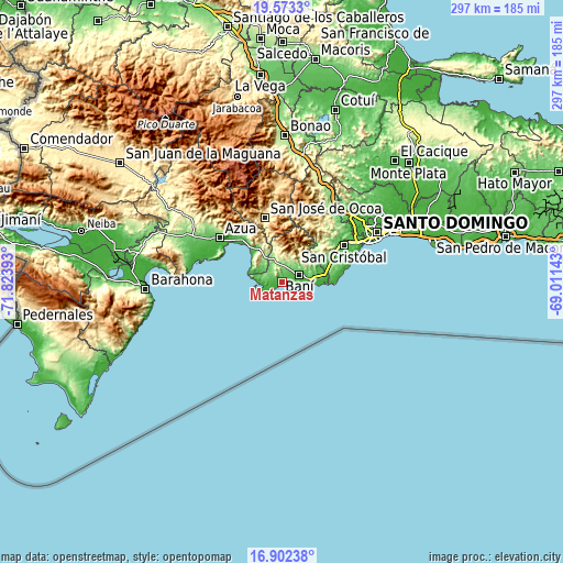
| \ | Map #1 | Map #2 | Topo.Map |
| Scale [m] | 0..450 m | 0..495 m | × |
| Scale [ft] | 0..1476 ft | 0..1624 ft | × |
| Average | 63.4 m = 208 ft | 88.5 m = 290 ft | × |
| Width | 9.28 km = 5.8 mi | 18.56 km = 11.5 mi | 297 km = 184.5 mi |
| Height | 9.28 km = 5.8 mi | 18.56 km = 11.5 mi | 297 km = 184.5 mi |
| ↑Max Latitude | 18.284701° | 18.326423° | 19.5733° |
| Latitude at center | 18.24297° | 18.24297° | 18.24297° |
| ↓Min Latitude | 18.201228° | 18.159477° | 16.90238° |
| ← Min Longitude | -70.461625° | -70.505571° | -71.82393° |
| Longitude center | -70.41768° | -70.41768° | -70.41768° |
| →Max Longitude | -70.373735° | -70.329789° | -69.01143° |
Nearby cities:
Cities around Matanzas sort by population:
• Baní elevation 67 m
9.9 km,  65°
65°
• Cambita Garabitos 184 m
33 km,  44°
44°
• Paya 47 m
13.1 km,  80°
80°
• Nizao 29 m
21.9 km,  88°
88°
• Yaguate 52 m
27 km, 67°
• Estebanía 61 m
33.7 km,  315°
315°
• Sabana Grande de Palenque 34 m
28.5 km, 85°
• Las Charcas 68 m
31.2 km, 317°
• Pizarrete 57 m
21.1 km, 72°
• Sabana Buey 78 m
11.7 km,  286°
286°
• El Cacao 403 m
34.1 km,  22°
22°
• Palmar de Ocoa 5 m
18.8 km, 288°
Multilingual:
 En español:
Matanzas elevación 39 m.
 En France:
Matanzas élévation 39 m.


Sources and notes:
- [note 1] Map square and city borders are not equal. Map elevation data is calculated only from area inside that square.
- [src 1] Elevation data from geonames database provided with same terms of usage.
- [src 2] The elevation map of Matanzas is generated using elevation data from NASA's 3 arcsec (90m) resolution SRTM data.
- [src 3] Base (background) map © OpenStreetMap contributors tiles are generated by Geofabrik and OpenTopoMap.
Copyright & License:
This Matanzas Elevation Map is licensed under CC BY-SA. You may reuse any part from this page, if you give a proper credit by linking to this URL:
 More info on terms of use page.