Tábara Arriba elevation
Tábara Arriba (Azua), Dominican Republic elevation is 296 meters and Tábara Arriba elevation in feet is 971 ft above sea level [src 1]. Tábara Arriba is a populated place (feature code) with elevation that is 133 meters (436 ft) bigger than average city elevation in Dominican Republic.
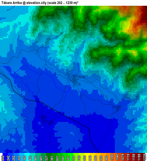
Below is the Elevation map of Tábara Arriba, which displays elevation range with different colors. Scale of the first map is from 202 to 1239 m (663 to 4065 ft) with average elevation of 375.7 meters (=1233 ft) [note 1]
These maps also provides idea of topography and contour of this city, they are displayed at different zoom levels. More info about maps, scale and edge coordinates you can find below images.
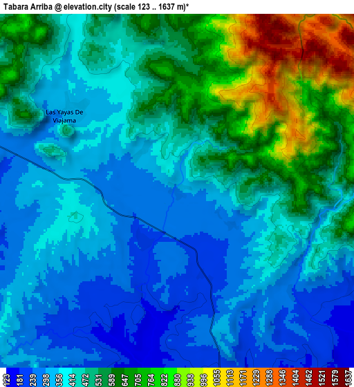
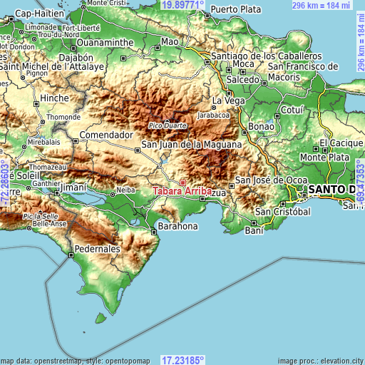
| \ | Map #1 | Map #2 | Topo.Map |
| Scale [m] | 202..1239 m | 123..1637 m | × |
| Scale [ft] | 663..4065 ft | 404..5371 ft | × |
| Average | 375.7 m = 1233 ft | 467.1 m = 1532 ft | × |
| Width | 9.26 km = 5.8 mi | 18.53 km = 11.5 mi | 296.4 km = 184.2 mi |
| Height | 9.26 km = 5.8 mi | 18.53 km = 11.5 mi | 296.4 km = 184.2 mi |
| ↑Max Latitude | 18.611642° | 18.653284° | 19.89771° |
| Latitude at center | 18.56999° | 18.56999° | 18.56999° |
| ↓Min Latitude | 18.528328° | 18.486655° | 17.23185° |
| ← Min Longitude | -70.923725° | -70.967671° | -72.28603° |
| Longitude center | -70.87978° | -70.87978° | -70.87978° |
| →Max Longitude | -70.835835° | -70.791889° | -69.47353° |
Nearby cities:
Cities around Tábara Arriba sort by population:
• Azua elevation 86 m
20.1 km,  130°
130°
• Vicente Noble 36 m
37.8 km,  236°
236°
• Sabana Yegua 393 m
21.8 km,  318°
318°
• Padre Las Casas 518 m
19 km,  340°
340°
• Peralta 482 m
11.6 km,  83°
83°
• Yayas de Viajama 317 m
6.5 km,  309°
309°
• Estebanía 61 m
27.9 km,  116°
116°
• Las Charcas 68 m
30.7 km, 115°
• Pueblo Viejo 24 m
22.3 km,  147°
147°
• Villarpando 287 m
19.5 km,  300°
300°
• El Guayabal 727 m
20.5 km,  12°
12°
• Bohechío 455 m
25.5 km,  333°
333°
Multilingual:
 En español:
Tábara Arriba elevación 296 m.
 En France:
Tábara Arriba élévation 296 m.
 Auf Deutsch:
Tábara Arriba höhe über dem Meeresspiegel ist 296 m.

Sources and notes:
- [note 1] Map square and city borders are not equal. Map elevation data is calculated only from area inside that square.
- [src 1] Elevation data from geonames database provided with same terms of usage.
- [src 2] The elevation map of Tábara Arriba is generated using elevation data from NASA's 3 arcsec (90m) resolution SRTM data.
- [src 3] Base (background) map © OpenStreetMap contributors tiles are generated by Geofabrik and OpenTopoMap.
Copyright & License:
This Tábara Arriba Elevation Map is licensed under CC BY-SA. You may reuse any part from this page, if you give a proper credit by linking to this URL:
 More info on terms of use page.